It’s hard to believe that we are already nearing yet another Winter season! It feels like just yesterday we were tracking the onslaught of winter storms that this past February had to offer. This forecast was not an easy one to make. Diving into the science and piecing everything together has kept me busy for the last couple of weeks! I have been producing winter outlook since the Winter of 2013-14, my senior of high school! Let’s quickly look over the prior forecasts I have developed before getting into this year.
Analyzing Records
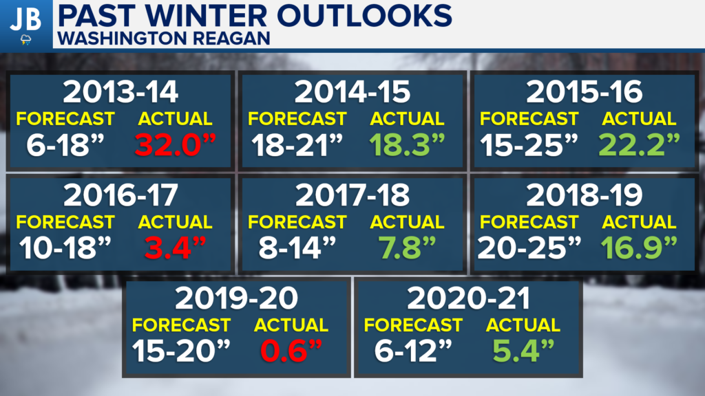
I have published eight Winter outlooks since JB Weather began. This should go without saying, but seasonal forecasting is notoriously hard. People joke that weather forecasters struggle enough to produce 7-day forecasts, so we should stray away from seasonal forecasting. The purpose of these sorts of forecasts is to provide you with general ideas of what to expect.
When looking at my snowfall seasonal predictions, 5 out of my 8 forecasts have produced pretty accurate results. One could make that the argument that the 2018-19 forecast missed the mark, and I think that argument could be valid. For purposes of this forecast, I am placing it in the correct column since the general theme of that outlook was for above-average snowfall, which we did indeed see. 2013-14 produced much more snow than forecasts with 2016-17 and 2019-20 producing far less snow. Whether you count it as 5-3 or 4-4-1, my record is not too bad, all things considered.
Clearly, some seasonal forecasts are better than others. Last winter, I forecasted for our region to see 6-12″ of snow with a few wintry mix events. Sure enough, much of our region saw 6-12″ (granted it all seemed to come in a 3-week period at the start of February) with 2 major icing events. We’ll see if this year’s forecast is as good.
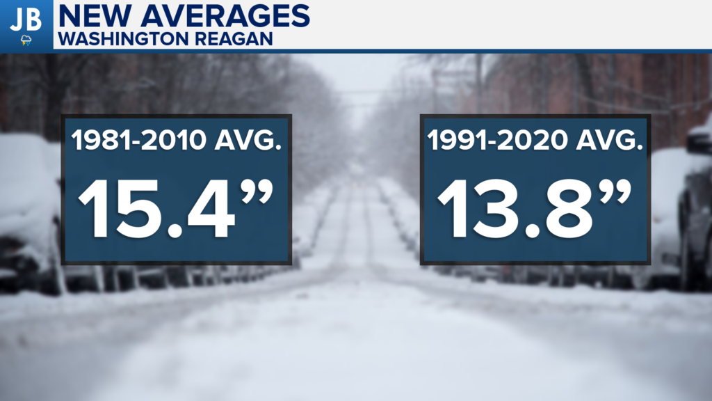
I want to also mention that we have new snowfall averages! Every 10-years our 30-year weather averages get updated. We finally have the new 1991-2020 average, which features a drop in our seasonal snow total. Before, our average seasonal total sat just over 15″. While we have seen some big-time snows over the last 30-years (such as ’96, ’03, ’09, ’10, and ’16), we have seen the number of winters with lackluster totals increase. The effect of this has led to our average decreasing by about an inch and a half. This development should not come as a surprise to most.
You may have noticed that I am using Washington DC’s Reagan National Airport as our record-holding location. This is because Southern MD has no official location of weather records for the National Weather Services. Reagan National, while it is to our northwest, actually has snowfall averages that does match pretty close to our averages which makes it a good substitute. Do take it with a grain of salt though.
Large Scale Drivers
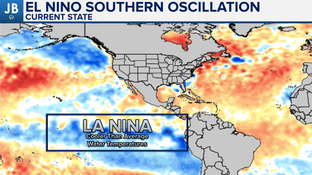
One of the biggest factors for our winters are the water temperatures along the Equatorial Pacific Ocean. These waters off the coast of South America dictate the presence of the southern storm track. We call the waters in this region the “El Nino Southern Oscilation”, or ENSO for short. Water temperatures in the ENSO region have remained below average this year, as they were last year. This means that we still have a La Nina present. This means that the storm track across the Southern US will be less active than in other years.
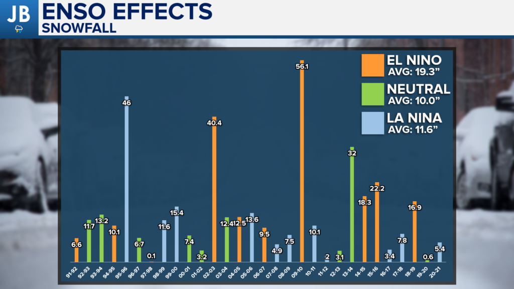
La Nina winters have typically featured below-average snow for our region due to that lack of an active southern storm track. Over the last 30-years, we have only had two La Nina winter produce above-average snows. With that said, second-year La Nina’s do typically feature more snow than the winter prior, so we will see if that trend holds.
What stands out the most on this chart are the 3 big snow years of 95-96, 02-03, and 09-10. Those years all featured an active storm track with at least 1 blizzard. With the absence of those three winters, our seasonal average falls to just 9.9″. This shows you how much our winter snow totals can rely on one big storm. This chart also shows you how much an El Nino set up can help out our snow totals.
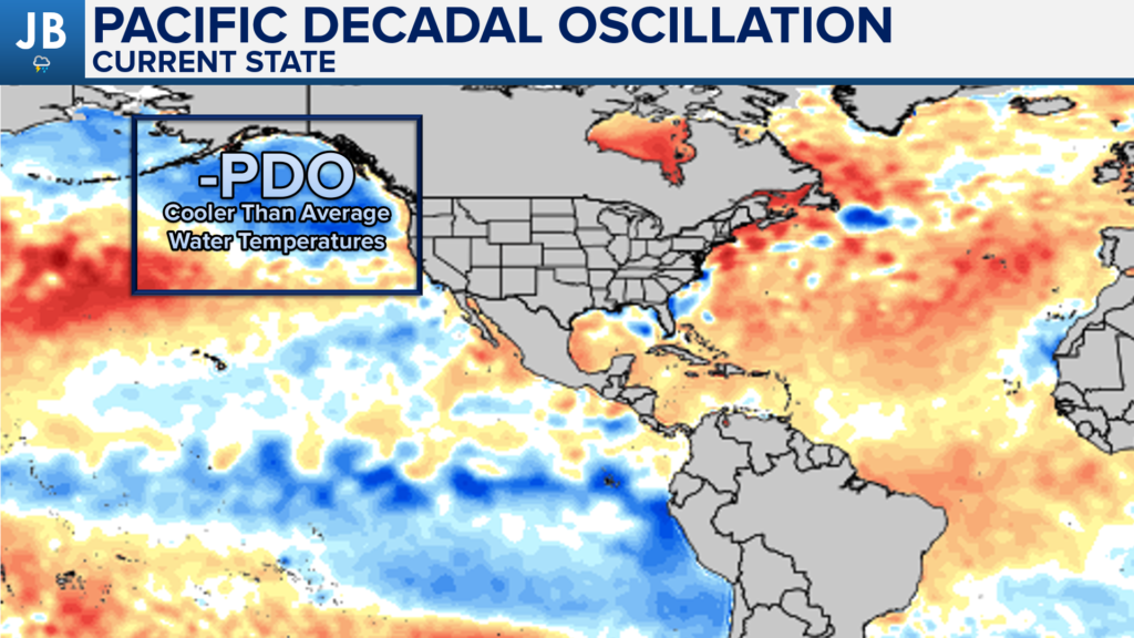
Another region that is important in determining our winter weather is an area of water off the Pacific Northwest coastline. This is referred to as the PDO. We are seeing an abundance of cool water in this region, which means we have a negative PDO. This would work against us seeing patterns that could lead to cold and snow in our region. This is because it develops an area of low pressure over Alaska, funneling the cold air into that region, as opposed to the Eastern US.
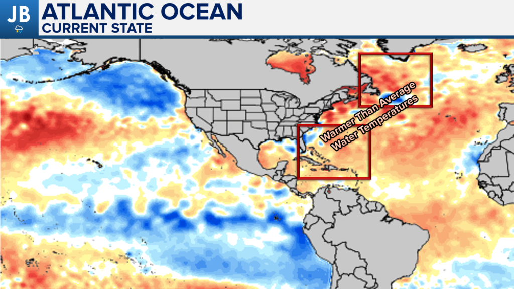
Additionally, the warm Atlantic waters will play a factor. The first way is that the presence of warm water off the SE coastline can develop an area of high pressure, known as the Southeast Ridge. The presence of this ridge can shove the Jet Stream to the north, and limit the cold air that can come southward. However, we also have a pool of warm water sitting near Greenland. This warm water can create a separate ridge of high pressure in that region. A ridge over Greenland would actually help to buckle the Jet Stream and retroactively stunt it southward over the East Coast. This could actually help bring a cold/snowy pattern to our region. We will need to see which warm pool wins out!
Overall Pattern
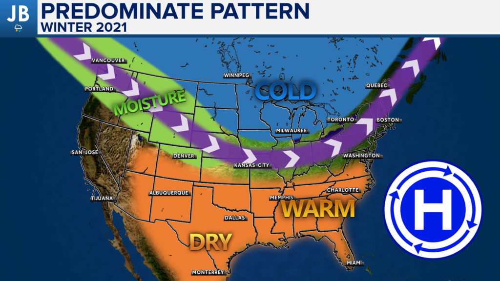
Putting all of these drivers, along with a multitude of other factors, together, I’m able to get an idea of what our predominant weather pattern will look like. I believe that this winter pattern could look a lot like last winter. I think that we will indeed see the Southeast Ridge pump warm air from the south into the Southeast and Mid-Atlantic regions. This will work to keep the Jetstream, shown by the blue line, to the north. This will allow warm air to dominate many areas south of the Jetstream. This does include our region. Areas in the southwest US will likely see a dry winter as well. Most of the cold and snow will be present along the northern tier of the U.S. That Jetstream placement will serve as the primary guide for storms this season. This means that the regions to the north of the storm track will see plenty of precip, including snow. The Jetstream will fluctuate through the season, and the Jetstream will be allowed to drop southward allowing our region to also get in on winter weather. However, I just do not expect that sort of dip in the Jetstream to be a consistent feature.
The one thing that could help send additional cold/snow chances to our region is if we do indeed see the warm water near Greenland help influence the development of a ridge in the North Atlantic. If ridges can develop in that part of the world, it would help to buckle the Jetstream and send more frequent cold/snow chances to the Mid-Atlantic. We will need to wait and see if that does indeed happen.
Snowfall Outlook
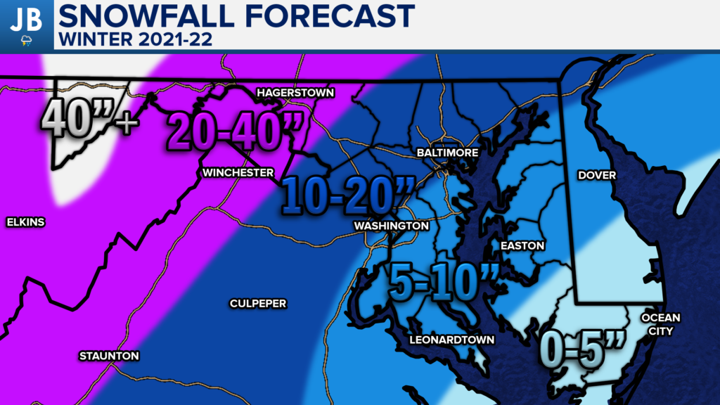
With all of this in mind, I am expecting snowfall totals that will be very similar to last year. That’s to say, I favor below-average snowfall for this winter. I think that a decent amount of our storms will take a track west of our region, which will lead to an injection of warm air for us, leading to more rain than snow. Any systems that don’t track to our west will likely feature rain/snow line issues, which will really hurt snow totals east of I-95. I think the main ways that we will see snow will be on the front end of snow-to-rain systems, or with storms that slide to our south. We have already noted that our southern storm track is not likely to be as potent due to La Nina. This means that if we do get any southern sliding systems that they will likely be weak.
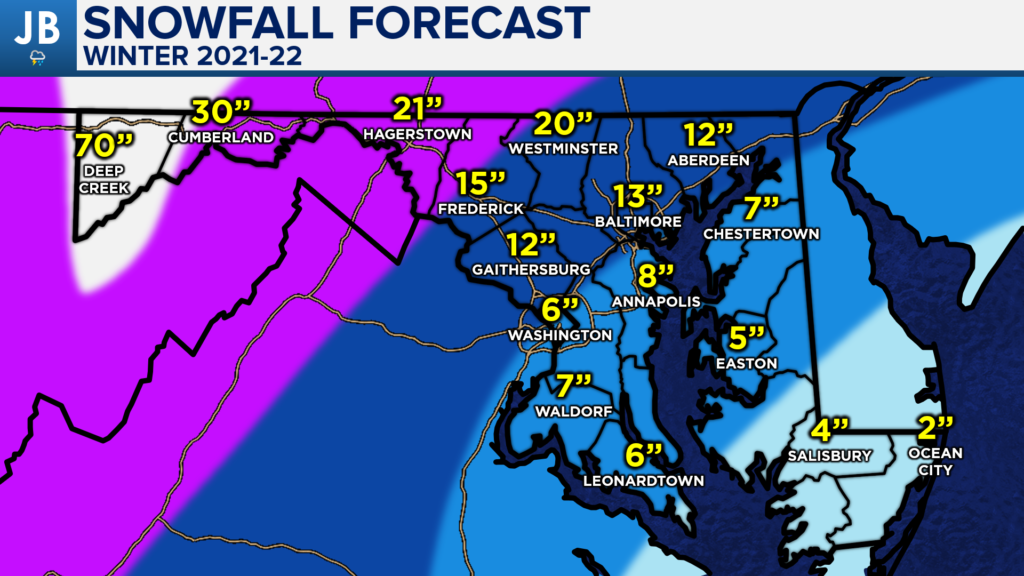
Snowfall totals this winter are likely to be below average across the board, but more snow will likely fall in the typically colder NW DC suburbs. Areas on Delmarva will likely struggle even more than Southern MD to see impressive snow totals. Below is a pinpoint forecast for this winter’s snow totals.
SUMMARY
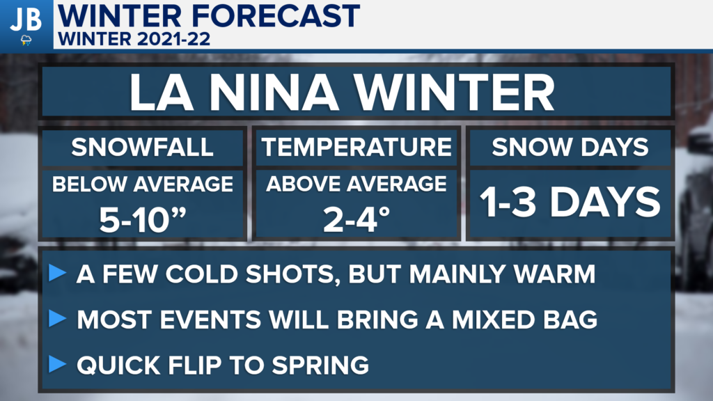
In summary, I think we’ll see a warm winter. Temperatures will likely be 2-4° above average. However, I do expect us to see some cold outbreaks this winter. I just believe that the warm weather will outweigh the cold outbreaks we see. We will likely also see average to above-average precipitation in our region. However, with a lack of sustained cold, we will struggle to see many snow events. Most events in our region will feature rain. The wintry events we do see could be mixed bag events. Those would be events that start as snow and go to rain, or start as rain and go to snow. If the Greenland ridge can develop this winter, that could help our region see at least a few snow events.
We average 10-14″ of snow across our region. I expect 5-10″ of snow this winter across our region. This means that snow totals across the region will be below average this winter. However, I do expect slightly more snow than last year though! I think that winter may get off to a fast start in December and January with a quick flip to Spring throughout February and into March. What about snow days? I would expect 1-3 days where winter weather could impact travel leading to school and business disruptions.
Stay tuned to JB Weather through the winter season for the latest Mid-Atlantic winter weather information!
-John A. Bordash

