Brought to you by Berkshire Hathaway HomeServices McNeils Group Properties
The active month of January continues to roll on as we are tracking yet another winter storm that is set to impact the Mid-Atlantic. This storm will be very different than the others we have experienced so far. This storm will focus its highest winter weather impacts northwest of I-95, with high impact rain and wind southeast of I-95. This is a very common setup for longtime Southern Maryland residents as we see a storm work up the coast. We will go over all the details of this complex setup in this rather lengthy forecast. For a quick overview, check out the Storm FAQs and Storm Summary at the bottom of this page.
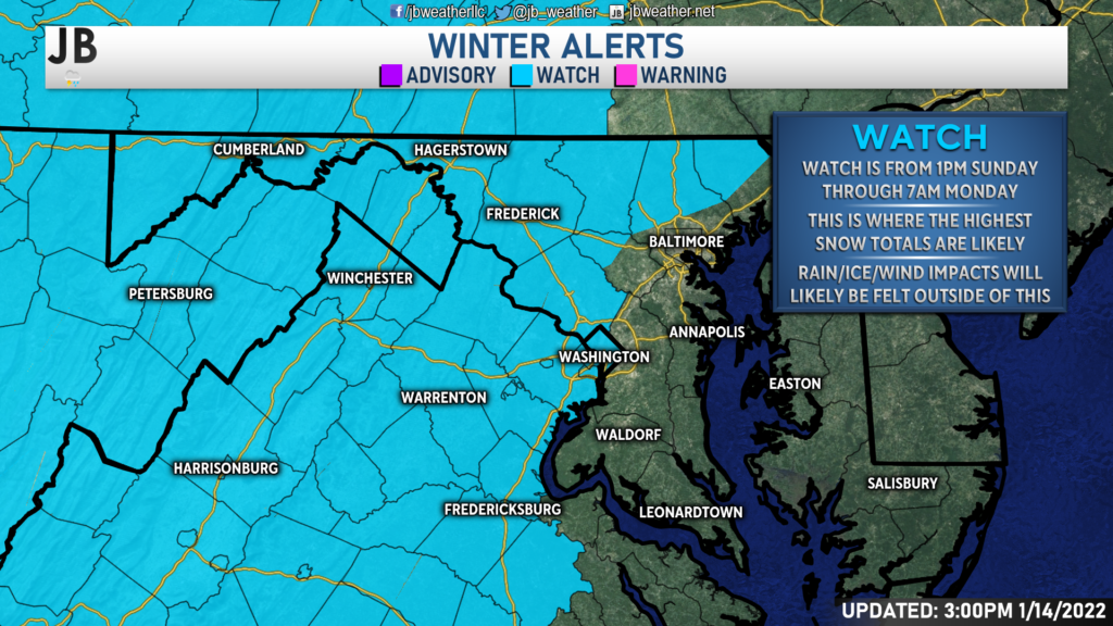
The National Weather Service has already issued Winter Storm Watches for areas west of I-95 late Sunday into early Monday. This region will see some of the higher winter weather impacts. Additional alerts will be coming out over the next couple of days as the details of this system continue to come into focus.
The Setup
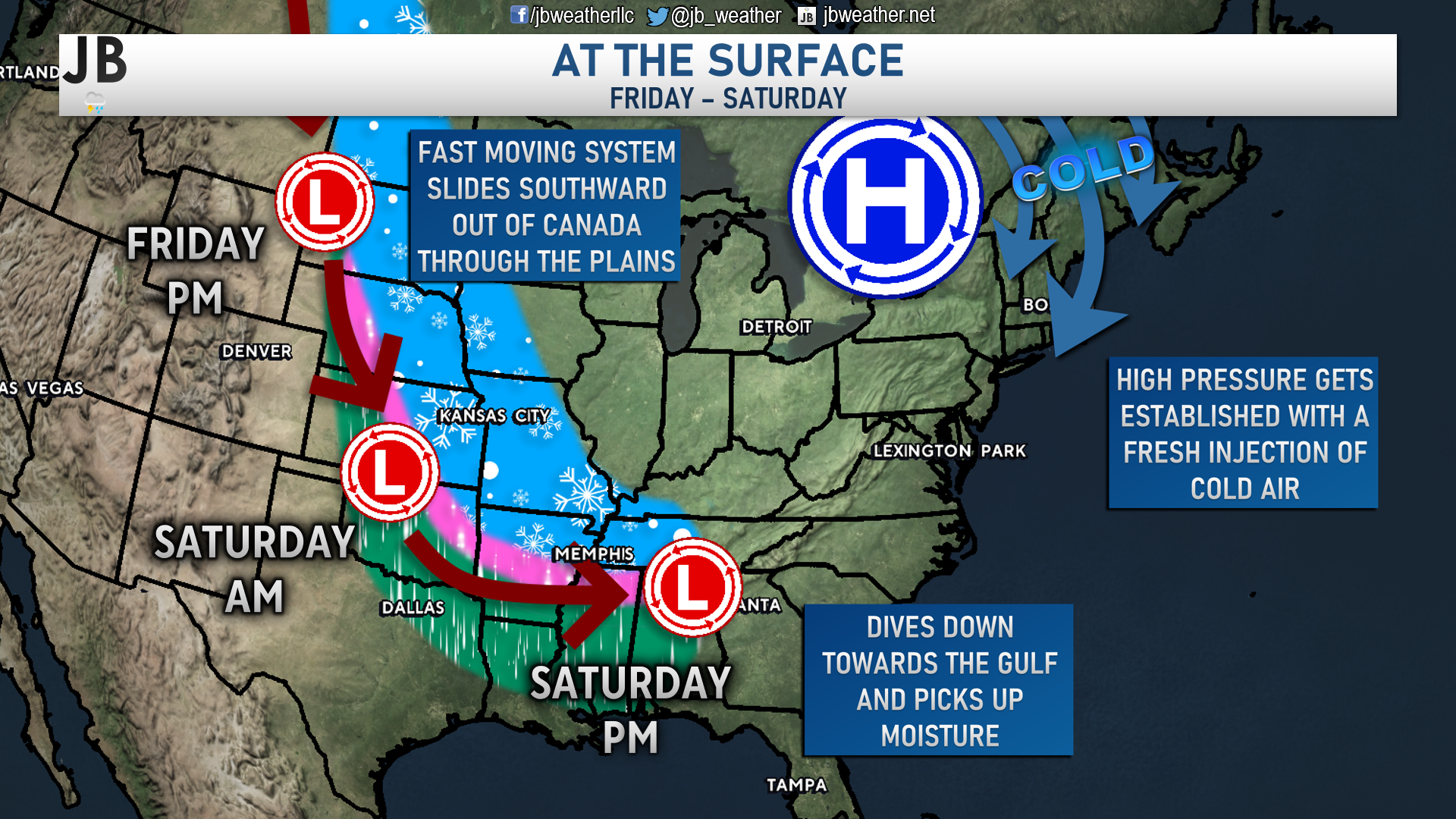
Today our storm system is tracking from southwestern Canada through the Plains and will arrive at the Gulf Coast on Saturday. At the same time, a new area of high pressure will be getting established to the north. How these two systems interact with each other on Sunday will help determine what we see happen in the Mid-Atlantic as this storm turns up the coast.
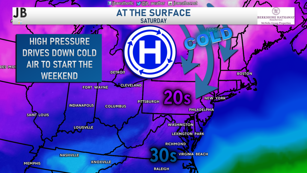
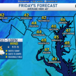
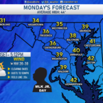
We have been talking all week about the shot of bitterly cold air that will move into the region on Saturday. It looks very likely that we may struggle to get out of the 20s on Saturday. On Saturday morning, a northwest wind may make it feel like we’re in the single digits locally. Spots north of DC could potentially see Wind Chill values on either side of 0°. Saturday will undoubtedly give us the Winter feel. This cold air is likely to stick around into Sunday as well, granted it will likely moderate a bit.
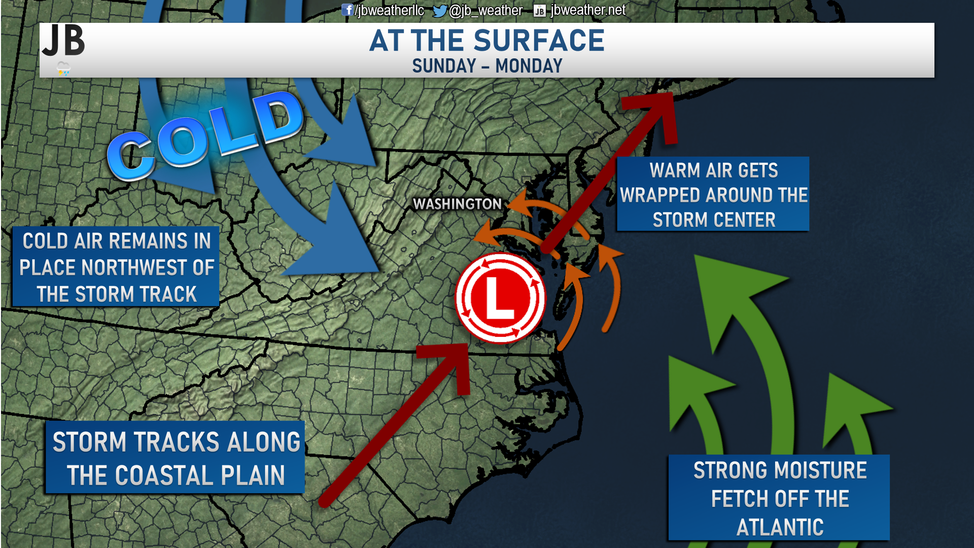
As our system turns up the coast, it will likely take a track northward along I-95. That track will allow the storm to really tap into a strong moisture fetch off the Atlantic. That fetch will supply ample moisture for this system to work with as it moves northward. The track and the moisture fetch will also allow warmer air to surge northwestward into the coastal plain. Winds around a low-pressure system are counterclockwise. These winds will help bring the warmer ocean water overhead of the coastal plain. While we will have lingering cold air in place from Saturday, the onshore flow of warmer will eventually overcome it. However, areas further northwest of the storm track will be allowed to stay colder as cold air filters in.
Timing
How would this storm play out? The last run of our Chesapeake’s Bounty Futurecast does an excellent job of depicting what could likely happen. We are likely to see precip begin falling around, or just after, lunchtime on Sunday. With temperatures in the upper 20s/lower 30s, this will likely start as snow for most everyone. However, as warmer surges northwestward, the snow will flip over to a mix and rain. How quickly that happens is dependent on your location relative to the storm track. Places further inland would see a more extended period of snow before the rain, while coastal areas could see a quick flip to rain. The rain/snow line looks pretty likely to eventually work its way as far west as I-81 and the Blue Ridge mountains.
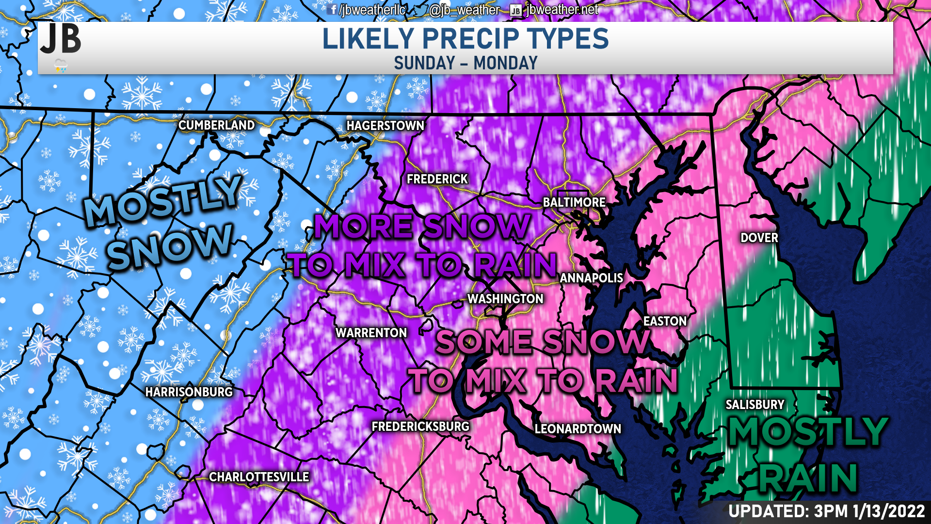
Our region will see a wide variety of precipitation types. Along the Atlantic beaches and lower Eastern Shore will likely see mostly rain. This is because the warmer air will easily flow overhead. A bit further inland, but along/east of I-95, there is likely to be a period of snow. Some light accumulations are possible before a brief transition to sleet and freezing rain and then to rain. The change from that mix to rain should be quick, preventing significant icing concerns. From I-95 to the Blue Ridge will likely see a more extended period of snow before a transition to sleet and freezing rain and then to rain. Some moderate snow accumulations are possible there before the switch to a mix. The mix could last longer here, leading to some icing issues (but it is too early to say to what extent). West of the Blue Ridge mountains will likely be mostly snow as the warm air will have a hard time getting that far west.
Accumulation Maps
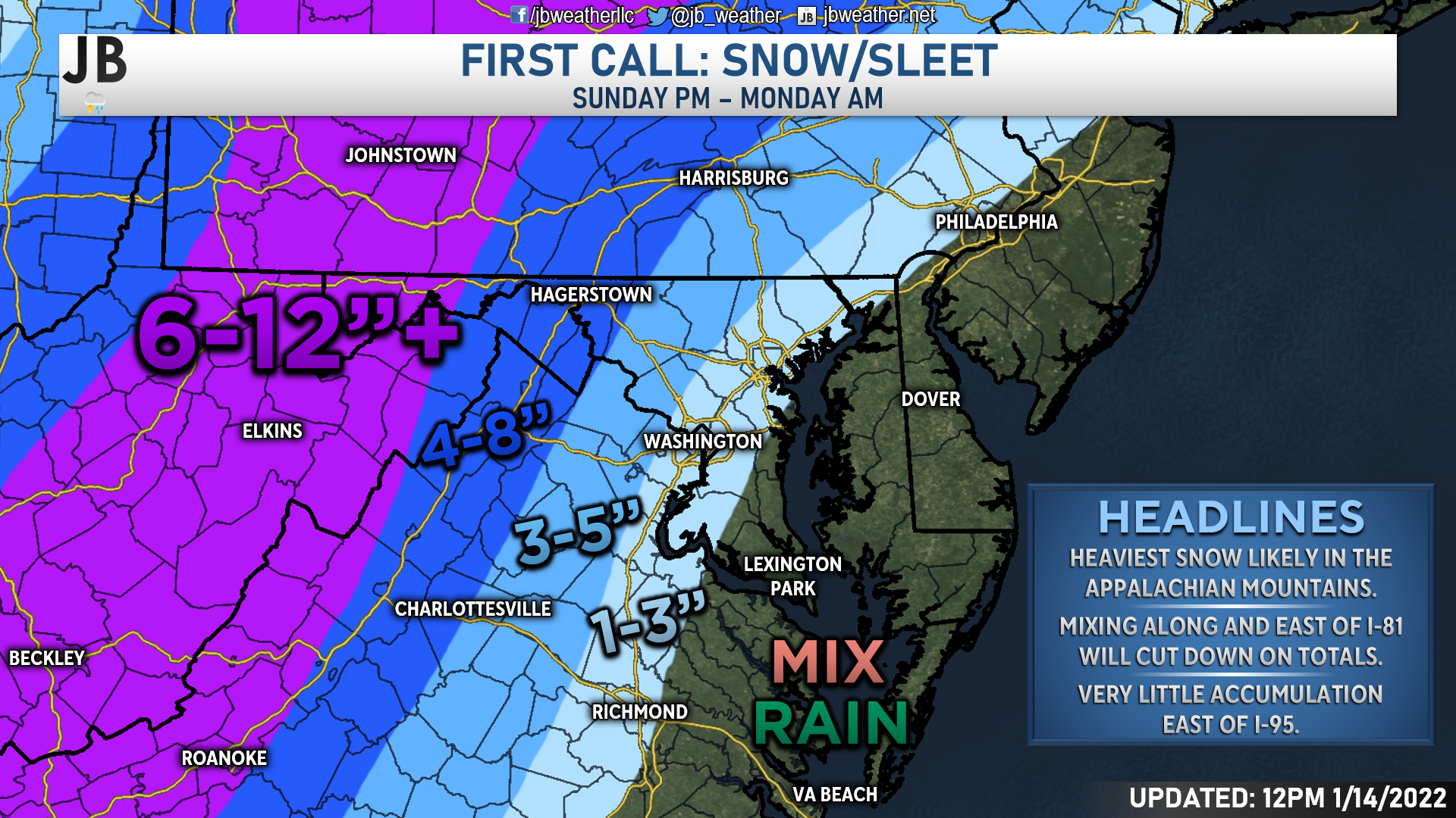
Areas in the mountains that can stay as all snow will likely rack up pretty significant snowfall accumulations. Right now, I would say that 6-12″+ looks pretty likely most areas along the Appalachians. The highest spots are likely to see over a foot of snow. Areas along I-81 that will see moderate snow before mixing with sleet and rain will still likely pick up between 4-8″ of snow. As you near I-95, the totals will really begin to fall off. I think the NW suburbs could pick up 3-5″ of snow in a few hours before the switch over to rain. Areas along I-95 may be able to squeeze out a quick inch or two before the switchover, with zones southeast of there not likely to see much snow accumulation.
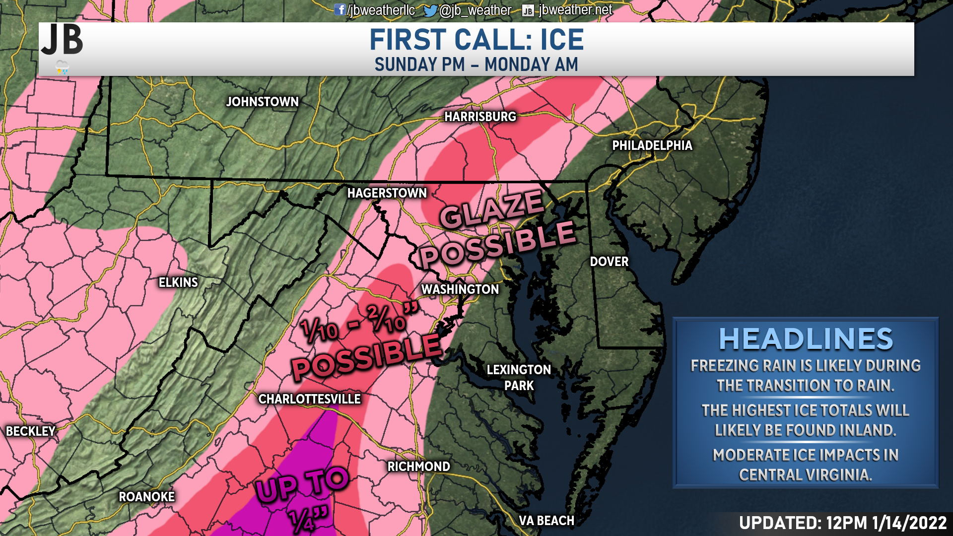
Ice will be another threat that the Mid-Atlantic has to contend with. Areas between I-95 and I-81 could see a prolonged transition from snow to rain in which freezing rain could become an issue. A glaze of ice looks possible for most zones, with localized regions of higher ice totals being very possible, especially across Central Virginia. While sleet and freezing rain are possible in Southern MD, the “warmer” Bay waters should help quickly raise our temperatures, limiting the ice threat.
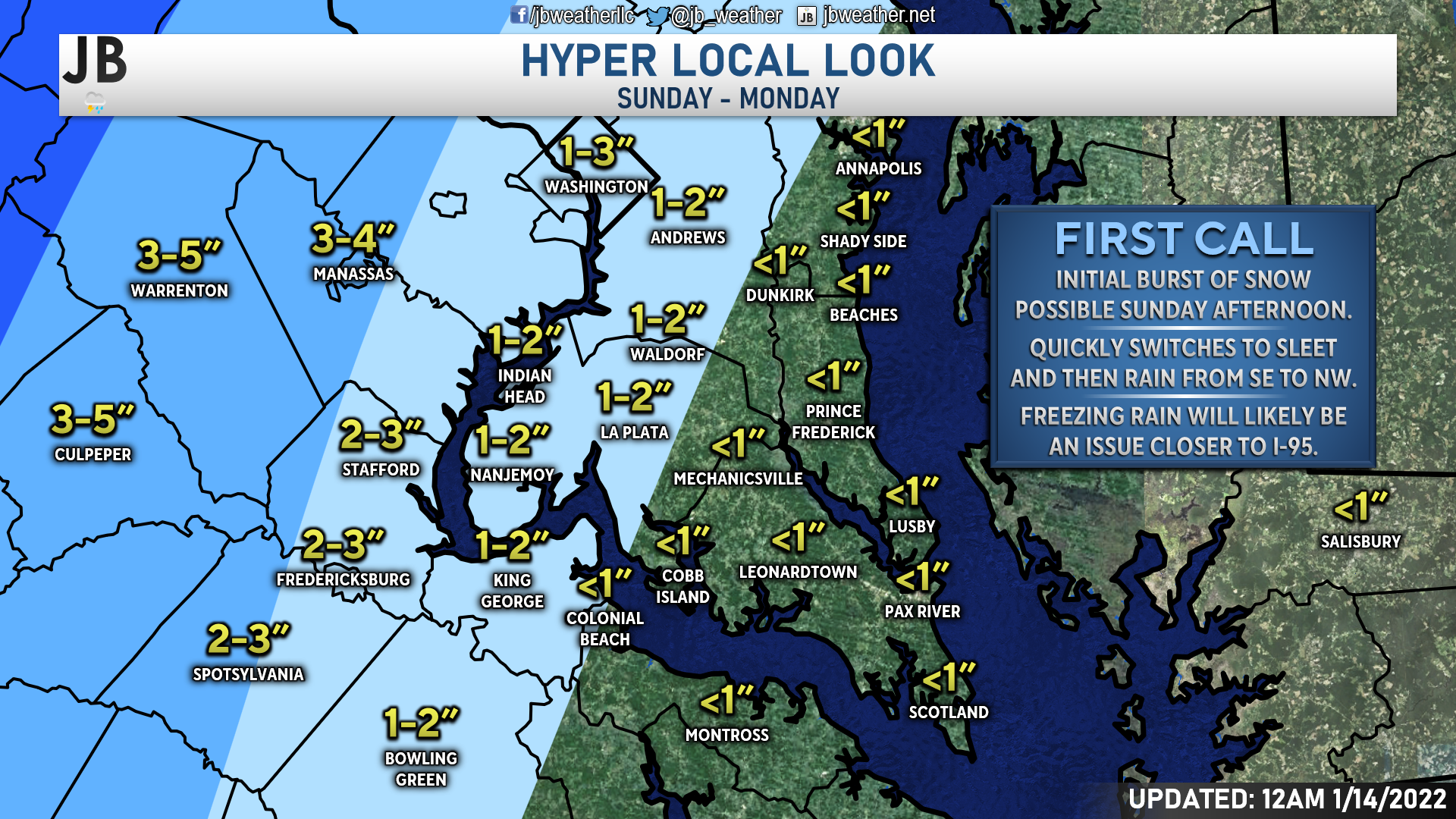
Again, locally I am not expecting much winter weather. I think that some spots along 301 and to the west could squeeze out an inch or two of snow quickly before the changeover. However, I think many of us see less than an inch of snow outside of that region. Freezing rain may be an issue in far western Charles County, in communities such as Indian Head, Bryans Road, and Marshall Hall, but that should be about it.
Impacts
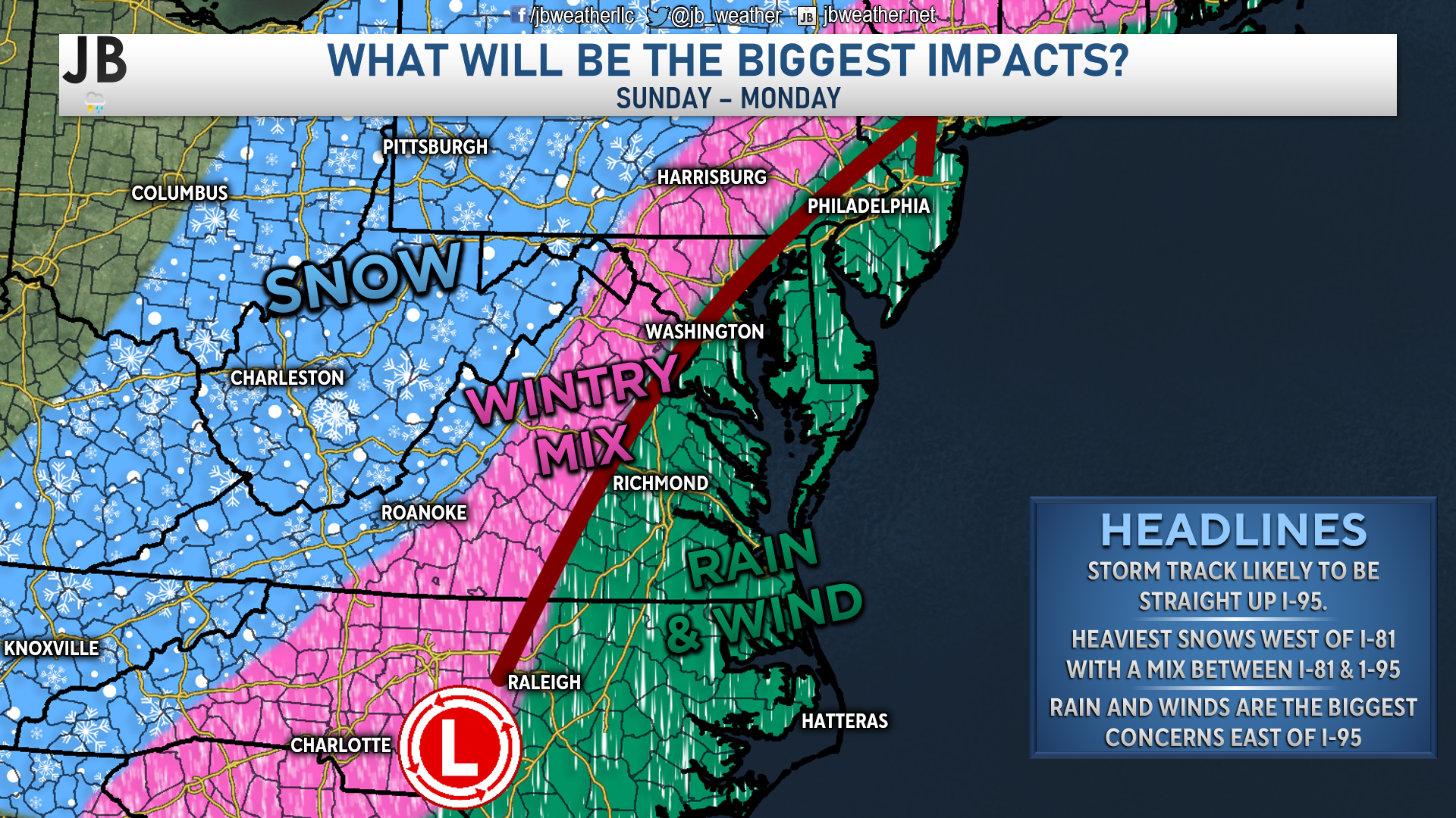
The map above is different from the precip-type map in that it shows you what will bring the highest impacts to a region. It looks like rain and wind will be the issues along and east of I-95. These spots, including Southern Maryland, could see up to an inch or two of rain and gusty winds. Between I-95 and I-81, the most significant impacts will come from snow, ice, and rain, leading to widespread roadway issues. From I-81 to the west, the most significant impacts will come from snow, as some communities there could see up to a foot or more!
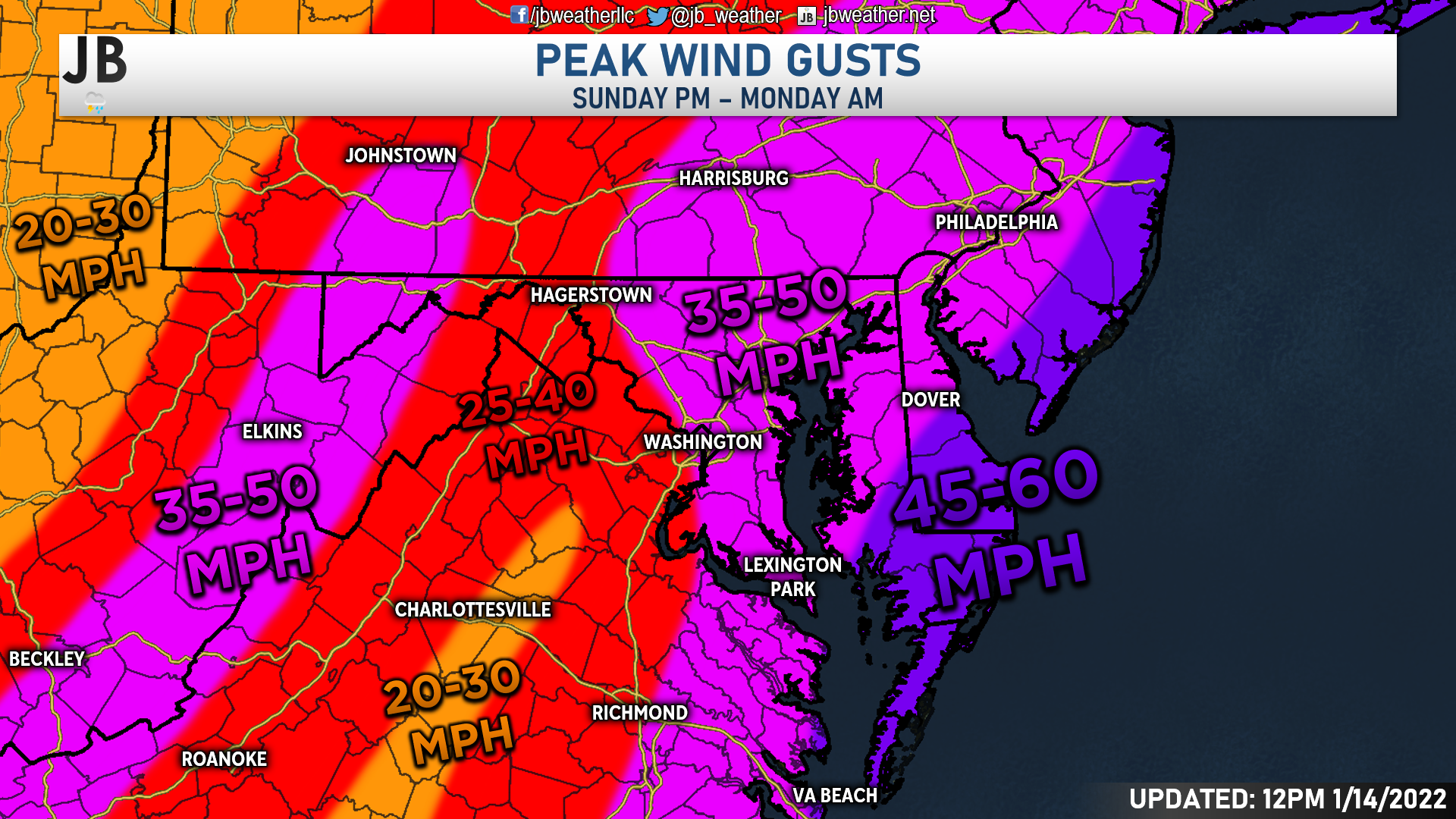
This strengthening storm will also bring with it a substantial wind threat. The onshore wind flow from the east will expose many areas to high winds. The front face Atlantic coastal areas will see the highest gusts, potentially 45-60mph. Areas further inland will see slightly lower gusts but still relatively high. Locally, our region could see gusts as high as 35-50mph, especially for immediate coastal areas. Thanks to heavier precip rates and the terrain, a secondary zone of higher gusts will also occur in the mountains.
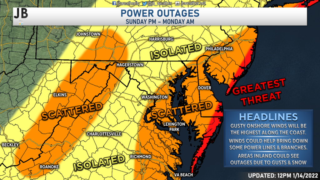
These gusts winds will lead to the threat of power outages. The greatest threat for outages will be along the coastline, where more widespread outages are possible. Areas southeast of I-95 and in the mountains will also have the threat of scattered outages. In addition to outages, coastal flooding could also become an issue. The most significant concern for this would be along the immediate Atlantic coastline. However, we could see elevated water rise of a foot or two along the western shoreline of the Bay.
Storm FAQs
How confident are you in your forecast? At this point, I feel somewhat confident in my forecast. We have seen consistency from our model guidance over the last several days on what is likely to happen. However, we could see last-minute shifts that could alter this forecast; so I am on guard for that.
Where will the heaviest snow fall? The heaviest snow will fall well to our west, across the mountains. Southern Maryland will be far removed from the snowfall bullseye with this storm.
When will the precip start? We will likely see precipitation move into the region around, or just after, lunchtime on Sunday. This could start as a period of snow for most before a quick transition to rain after a couple of hours.
Any chance of a wintry mix of freezing rain or sleet? We are likely to see a short period of sleet and freezing rain as we transition to plain rain. Give on the onshore flow of the winds, the warmer air associated with the Bay should help to warm up quick enough to prevent a widespread icing event. Now, if the cold air hangs on longer, then we could see a glaze of ice in some locations.
When will the precip end? We will likely see the rain wrap up early Monday morning, before dawn.
How much snow will I get at my house? If you’re in Southern Maryland, you likely won’t see much. Certainly not the 30-40″ of snow that some saw on a viral post…
Could more or less snow fall than currently forecast? Yes. Granted, I’m not sure much less could fall than what I am currently forecasting for Southern MD. Granted, areas along I-95 could see less if the warm air moves in quicker. We could see more snow and/or ice if the cold air holds on longer than forecast or the storm’s track were to shift eastward. While both could happen, I wouldn’t bank either happening at the current moment. Here’s how I see snowfall odds in Southern MD, right now:
60% chance: <1″
25% chance: 1-2″
10% chance: 2-3″
5% chance: 3-4″+
Will we see power outages? Outages are certainly possible with this storm. With wind gusts up to 35-50mph, scattered outages are a concern.
Summary
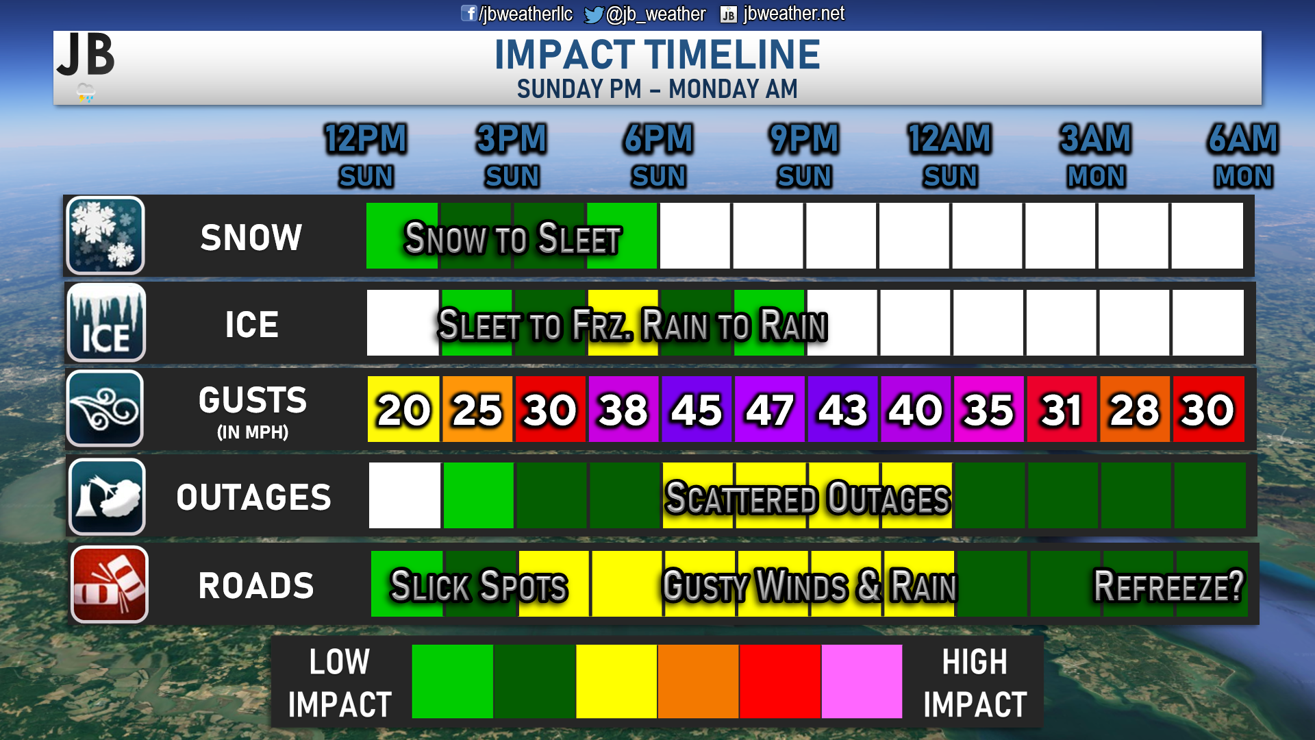
While Southern Maryland may not be seeing much snow from this storm, we are likely to still see high impacts. Precip will look to move into the region after lunchtime on Sunday. With the residual cold air still in place from Saturday, this could start as a period of snow for most. However, onshore winds will allow the “warm” air associated with the Bay to warm our temperatures quickly. After an hour or two of snow, a quick transition to sleet or freezing is likely. As temperatures continue to warm, this transition to ice is not expected to stick around long in our region. We should quickly transition to all rain by sunset.
Winds will be elevated in our area with this storm, though. Winds could gust up to 35-50mph at the peak of this storm Sunday night. This could lead to scattered power outages across our region, as well as coastal flooding. Travel may be difficult on Sunday and Monday as well. Initial slick spots Sunday afternoon should melt away as we transition to rain. However, the gusty winds and heavy rain become an issue then. Temperatures will likely cool down as the storm moves away Monday morning, potentially leading a minor refreeze.
Stay with JB Weather for the latest information on impacts here in Southern Maryland. You can always access my forecasts and updates here on the website, on Facebook, on Twitter, and on YouTube. JB Weather is Southern Maryland’s Weather Leader, and I am working around the clock to keep you ahead of any storm!
-JB
Real Estate now! Not sure where to start? View our Southern Maryland inventory of homes, land, farms and commercial properties on mcnelisgroup.com. Engage with our planning tools to determine your next real estate lifestyle decision, choose your realtor as a trusted advisor. Experience the difference with service and support from real estate’s forever brand!
John Bordash
View More PostsJB Weather forecaster John Bordash is working around the clock to provide Southern Maryland, and neighboring communities, with accurate and reliable weather information.