


Severe Weather Watches Issued Across the Region Through 9 PM
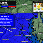
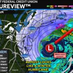
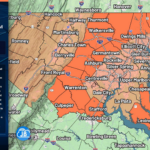
The Storm Prediction Center has issued both Tornado Watches and Severe Thunderstorm Watches across the Mid-Atlantic as a volatile atmosphere continues to support severe thunderstorm […]

The Storm Prediction Center has issued both Tornado Watches and Severe Thunderstorm Watches across the Mid-Atlantic as a volatile atmosphere continues to support severe thunderstorm […]
After several days of thick Canadian wildfire smoke, the atmosphere is finally beginning to recover. Winds have shifted to the south this morning, helping push […]
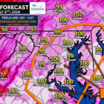
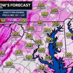
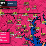
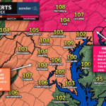
Heat index values around 105 are expected from 11 AM this morning to 7 PM EDT this evening across Washington DC, and portions of central, […]
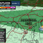
Brought to you by Cedar Point Federal Credit Union Our area has now been upgraded to a Level 3 “Enhanced Risk” for severe thunderstorms on Saturday. […]
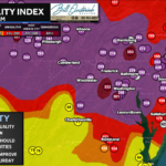
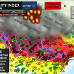
The Maryland Department of the Environment has issued a Code RED Air Quality Alert for Southern Maryland this Friday. Air pollution levels are unhealthy for […]