Brought to you by R.E. Graves Heating & Air Conditioning
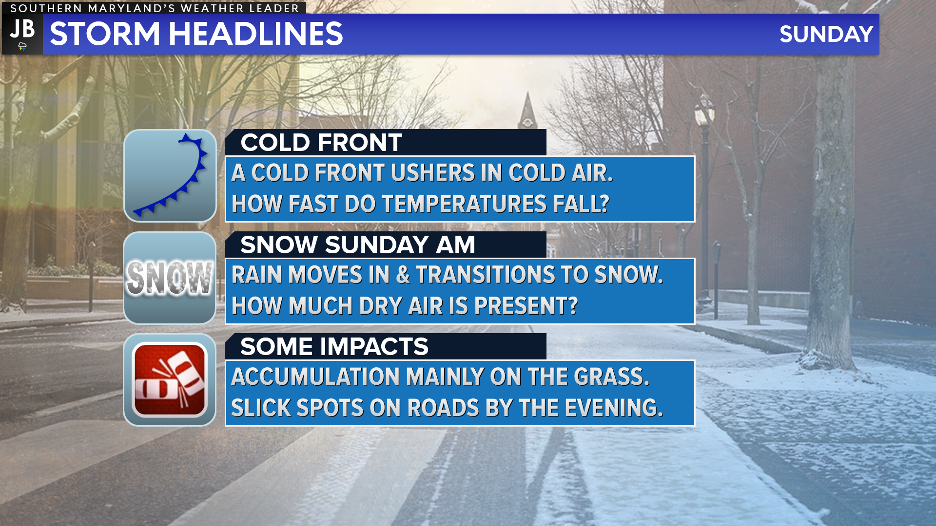
We have another Spring-like day on tap across the region, with afternoon highs getting into the lower to middle 60s by this afternoon. Unfourently, our warm streak will come to an end this evening as a cold front moves through the region and ushers in a fresh injection of cold air.
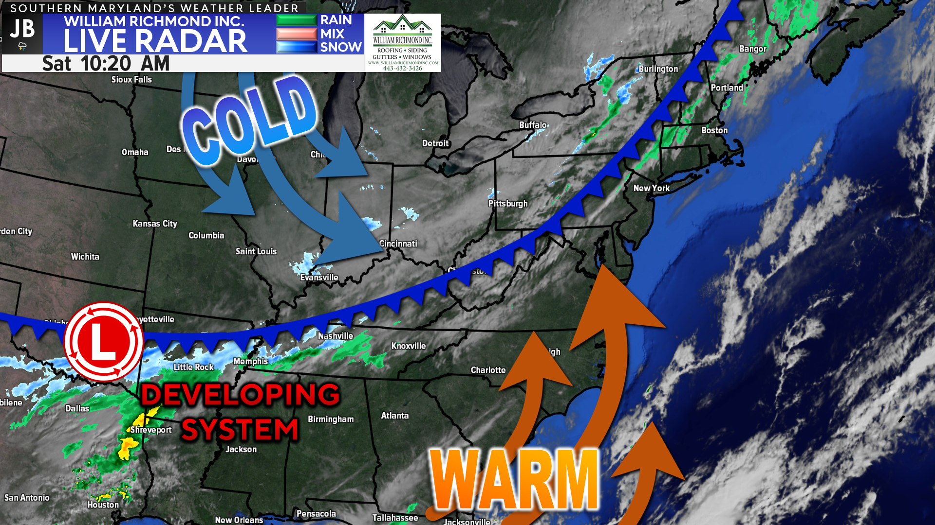
On the radar this morning, you can see where our system is beginning to develop across the Southern Plains. This system will ride northeastward along the cold front that will push through tonight. We should see the system reach our region around midnight tonight, as cold air filters in.
Our Chesapeake’s Bounty Futurecast does a pretty good job of depicting the timing with this system. After a warm day, we are likely to see the precip start as scattered rain showers around midnight. However, as temperatures cool, we will see that go over to snow as the precip builds.
Futurecast shows that the snow will start to our northwest initially and gradually slide southeastward throughout the morning. Scattered snow showers are possible into the afternoon before gradually clearing up. There are some indications that light snow showers may stick around overnight Sunday, too.
My main questions/concerns are about the dry air and temperatures. Firstly, how much dry air is present. There will be a narrow band of heavier snow, with dry air on either side of it. Where does that band set up, and how long does that subsequent dry air stick around?
Secondly, how quickly do temperatures cool behind the front? Think back to a few weeks ago, when a front was due to bring 1-3″ of snow to the DC area, but ultimately just brought rain. This will be a similar setup, where the cold air will need to come in quick enough to transition zones over to snow.
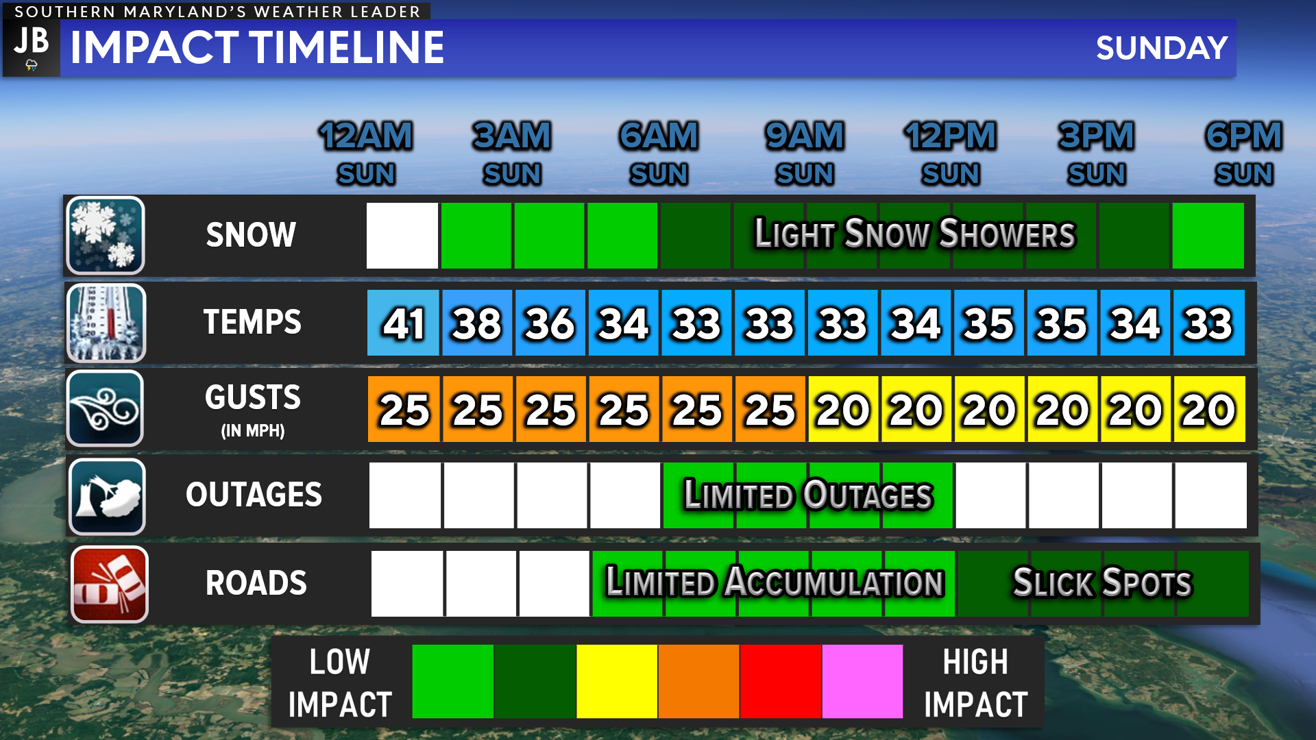
Locally, I think the main timeframe for light snow showers would be between 6am-6pm tomorrow. However, the impact will be relatively low since I do not expect heavy snow. Temps will gradually fall throughout the night, allowing any rain to go to snow, baring that dry air.
Accumulation will likely only be confined to grassy and colder surfaces given our recent warm stretch. I expect many of our roads to be fine here in Southern MD. With that said, some residual slick spots are possible tomorrow evening as temps cool. Power outages are not expected.
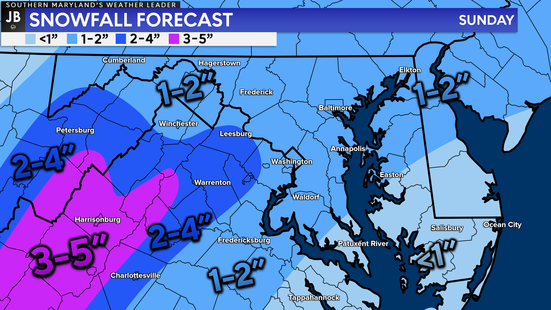
The axis of snow has shifted slightly to the north from yesterday. That “sweet spot” band looks to set up just to our north. I have concerns about dry air being prominent in our region initially on Sunday morning.
The highest accumulations will be found in the central Shenandoah Valley. The higher elevation there will allow for cooler temps and slightly heavier precip. Much of the Northern VA piedmont and WV foothills should manage 2-4″.

I think a wide swath of the region, mainly north of Leonardtown and St. Leonard will see 1-2″. South of there, I think you could still up to an inch, but much more than that could be hard to come by. But again, if the dry air isn’t as problematic, then this region too could see up to 2″ as well.
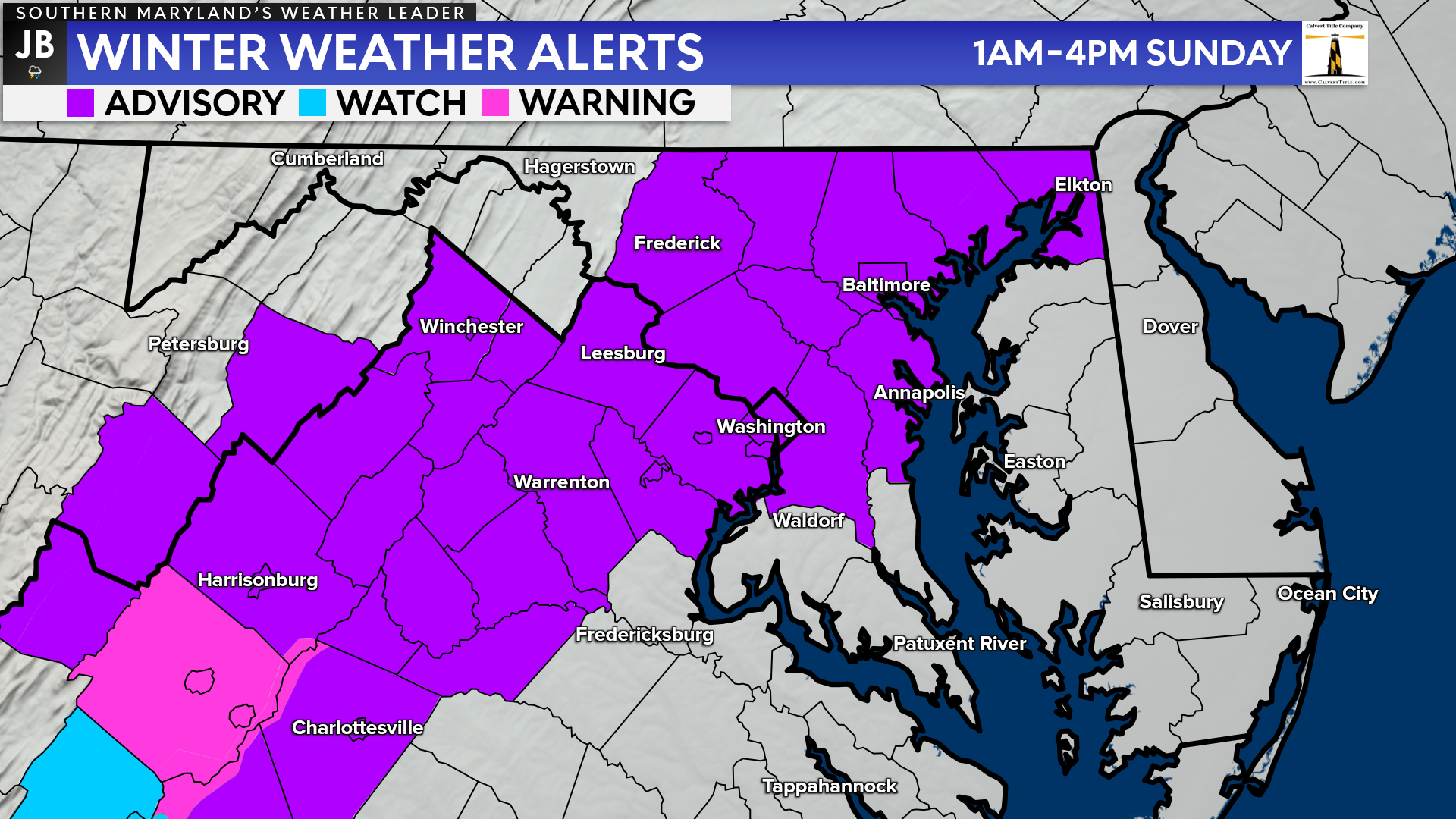
Winter Weather Advisories have been hoisted along and northwest of I-95, in the purple shaded zone. Winter Weather Advisory issuance criteria is seeing 2″ of snow, and this will be the most likely region to see that happen. Snow will fall outside of this zone, but not as much.
As we have been saying for a few days now, this does not look to be a big event. We are talking only about minor totals of up to an inch or two, with limited accumulation on roadways. Much of the snow should be out of here in time for Super Bowl viewing parties. Do be aware that we could see slick spots develop by the evening, thanks to cooling temperatures.
It will be important to stay with JB Weather for the latest information on this system and its impacts here in Southern Maryland. You can always access my forecasts and updates here on the website, on Facebook, on Twitter, and on YouTube. JB Weather is Southern Maryland’s Weather Leader, and I am working around the clock to keep you ahead of the storm!
-JB
R.E. Graves Heating & Air Conditioning is a ⭐️⭐️⭐️⭐️⭐️ HVAC Contractor serving St Mary’s & Calvert. Just mention JB Weather to Save 20% off your next Heating repair bill when you Book now! https://bit.ly/3kFvjRs
John Bordash
View More PostsJB Weather forecaster John Bordash is working around the clock to provide Southern Maryland, and neighboring communities, with accurate and reliable weather information.