Brought to you by Cedar Point Federal Credit Union
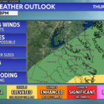
The Storm Prediction Center has issued a Tornado Watch for portions of eastern North Carolina and southeast Virginia until 9:00 PM EDT.
Primary threats include:
- A couple of tornadoes possible
- Scattered large hail and isolated very large hail events to 2″ in diameter possible
- Scattered damaging wind gusts to 70mph possible
SUMMARY: At least a few semi-discrete supercells should develop with primary initial threat of large hail. The tornado threat will likely be maximized near the Virginia-North Carolina border area. Damaging winds will also be possible as storms consolidate into small clusters.
PRECAUTIONARY/PREPAREDNESS ACTIONS: Remember, a Tornado Watch means conditions are favorable for tornadoes and severe thunderstorms in and close to the watch area. Persons in these areas should be on the lookout for threatening weather conditions and listen for later statements and possible warnings.
Cedar Point has been providing trusted banking, lending and personal finance solutions to the Southern Maryland Community since 1945. Visit the credit union at any of its 6 locations in St. Mary’s, Charles and Calvert counties or online at www.cpfcu.com.
John Bordash
View More PostsJB Weather forecaster John Bordash is working around the clock to provide Southern Maryland, and neighboring communities, with accurate and reliable weather information.