Brought to you by Berkshire Hathaway HomeServices PenFed Realty
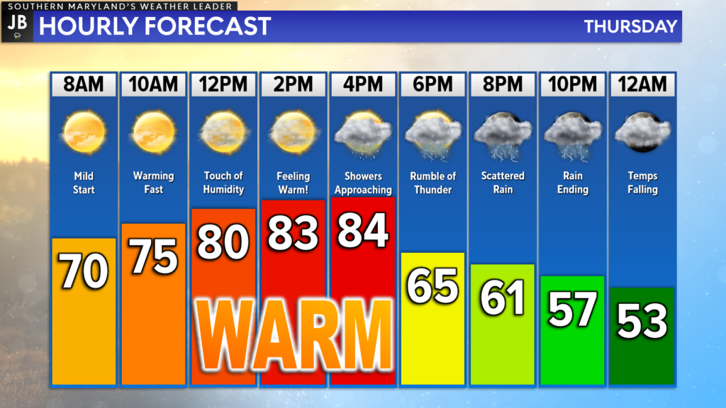
Today looks to be our last super warm day of the week. Temperatures this afternoon will likely max out in the lower to middle 80s before a cold front swings through this evening, bringing a chance of rain for many spots. This will usher in more typical April temperatures tomorrow.
Yesterday was our warmest day of the year yet! With plenty of sunshine and southwesterly winds, we saw temperatures overperform quite a bit. Most locations saw highs yesterday in the upper 80s! Temperatures will not be that warm day, but with enough sunshine, we should get back into the 80s.

We are off to quite the warm start already this morning. Temperatures only dropped down into the upper 60s/lower 70s overnight, definitely giving us that summer-like feel. Mostly sunny skies and a continued southwest flow will allow temperatures to quickly warm into the 80s by this afternoon, with a touch of humidity.
What will prevent temperatures from getting as warm as they did yesterday will be an approaching cold front that will move through during the mid-to-late afternoon hours. This front brings the chance of rain through this evening, and ushers in a noticeable temperature drop tonight.
Futurecast does a pretty good job of depicting today’s rain threat. What I did with today’s Futurecast video is have it show both the simulated radar as well as it’s projected temperatures in the background. You will notice the background colors change, and those colors translate to temperatures. Reds are the 80s, oranges are 70s, yellows are 60s, greens are 50s, and blues are 40s. Doing this allows you to see how our temperatures react as the front approaches and moves through.
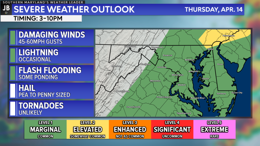
You can notice how the temperatures spike up right before the front moves through and dramatically cool off behind the front. That stark temperature and humidity difference will help to form a broken line of showers and storms along the front. These showers and storms will look to move through between 3-10PM.

The risk of severe weather with this front is rather limited today. Our region is under a Level 1 “Marginal Risk” this afternoon to potentially see wind gusts up to 60mph within a couple of storms. The greatest severe risk is likely to be to our northeast, where atmospheric conditions are more aligned to support severe weather.
I do not think that everyone will see thunderstorms today, but everyone should at least see some rain today as the front moves through. You could see that clearly depicted on Futurecast. I also do not think that we are talking about a lot of rain. At most, we may see spotty amounts of up to half an inch.
Stay with JB Weather for the latest information on Southern Maryland weather. You can always access my forecasts and updates here on the website, on Facebook, on Twitter, on Instagram, and on YouTube.
-JB

Real Estate now! Not sure where to start? View our Southern Maryland inventory of homes, land, farms and commercial properties on penfedrealty.com. Engage with our planning tools to determine your next real estate lifestyle decision, choose your realtor as a trusted advisor. Experience the difference with service and support from real estate’s forever brand!

