The Storm Prediction Center has issued a TORNADO WATCH for Southern Maryland, and areas east of I-81. This watch is in effect until 9PM Thursday.
Primary threats this evening are:
- Scattered damaging wind gusts to 65MPH
- 1 or 2 spin up tornadoes
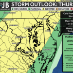
SUMMARY: Strong to severe thunderstorms are expected to develop this afternoon initially across southeast Pennsylvania into Maryland/Virginia Blue Ridge vicinity. A relatively moist/unstable environment along with moderately strong southwesterly deep-layer winds will support sustained multicells and potentially some supercells. Thunderstorm-related wind damage is the most probable risk, but some hail and a low tornado risk will exist as well.
PRECAUTIONARY/PREPAREDNESS ACTIONS: A Severe Thunderstorm Watch means conditions are favorable for severe thunderstorms in and close to the watch area. Persons in these areas should be on the lookout for threatening
weather conditions and listen for later statements and possible warnings. Severe thunderstorms can and occasionally do produce tornadoes.
Stay with JB Weather for continuing coverage on Southern Maryland severe weather.
John Bordash
View More PostsJB Weather forecaster John Bordash is working around the clock to provide Southern Maryland, and neighboring communities, with accurate and reliable weather information.