Brought to you by Calvert Title Company
After a comfortable Memorial Day weekend, we have seen the heat ramp up this week! This heat will stick around for tomorrow before a cold front moves through. With that front moving through late tomorrow, we will likely see scattered storms develop as the cooler rushes. This will set up the potential for severe weather.
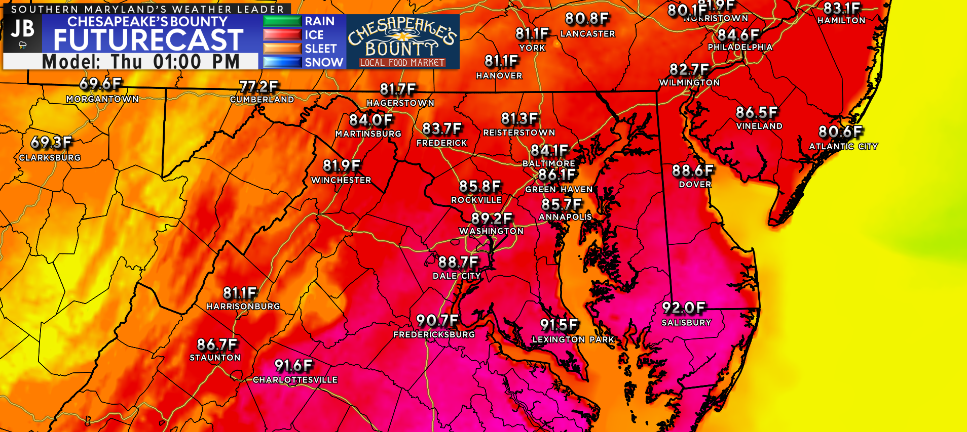
We saw temperatures yesterday get up to 94°, with many spots making another run into the middle 90s again today. Tomorrow, we will likely get back up around 90° out ahead of the front. We will also see the humidity tick up a bit, making it feel oppressive! This will lay the groundwork for strong storms to develop.
Tomorrow is likely to start with mostly sunny skies for many areas south of the Mason Dixon Line. This will allow those temperatures to get back near 90 and for the humidity to soar. The combination of heat and humidity will lead to the development of thunderstorm energy in the atmosphere, known as “convective available potential energy” (or CAPE). The more sunshine we see tomorrow, the warmer and more humid we can get, and the higher the CAPE values can become.
We will see a cold front back out to our west begin to push eastward throughout the morning and afternoon hours. This push of cooler air will act as the trigger to set off scattered thunderstorms. Our Futurecast model shows thunderstorms beginning to develop after lunchtime, and crossing I-95 throughout the afternoon in what could be multiple waves. These thunderstorms will look to tap into the high amount of CAPE in the atmosphere, which could turn a few storms strong or severe.
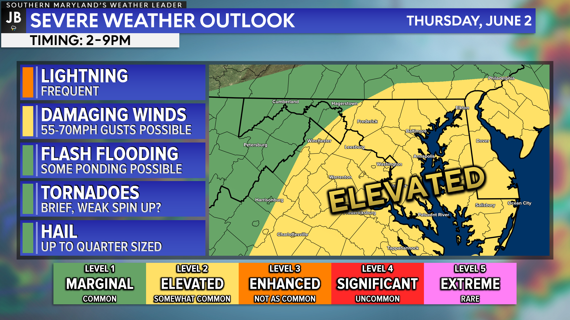
Right now, the Storm Prediction Center has placed much of our region under a Level 2 “Elevated Risk” of seeing severe weather tomorrow. The highest potential will be east of the Blue Ridge, closer to I-95 and the coastline. This is where the highest temperatures and humidity levels will be found, leading to higher CAPE values, and allowing thunderstorms to potentially reach peak strength the further east they head.
The biggest weather concern tomorrow will be the threat of storms to have damaging wind gusts up to 70mph. Storms may also produce up to quarter-sized hail and the threat of some flash flooding. There is also a non-zero tornado risk tomorrow afternoon as storms move eastward. The setup is not nearly as conducive for tornadoes as it was last Friday. However, there could be enough spin in the atmosphere (referred to as shear) to allow one or two storms to rotate and produce a weak, brief spin-up.
Keep in mind that severe weather forecasting is far from a guarantee of anything. The goal of these forecasts is to alert you to the potential of storms, not a promise of storms.
The timing to be aware tomorrow really looks like 2-9pm! The further west you head the earlier, the further east you head the later. It will be important to stay weather aware and to have a way to get weather alerts. Conditions tomorrow could change quickly and could vary quite a bit from location to location.
Stay with JB Weather for the latest information on Southern Maryland weather. You can always access my forecasts and updates here on the website, on Facebook, on Twitter, on Instagram, and on YouTube.
-JB
Calvert Title Company is guiding you HOME one closing at a time! Check out https://calverttitle.com/ today!
John Bordash
View More PostsJB Weather forecaster John Bordash is working around the clock to provide Southern Maryland, and neighboring communities, with accurate and reliable weather information.