Brought to you by Chesapeake Orthodontics
Our morning round of storms has pushed through the region, bringing a few areas some heavy rain and lightning to kick off the day. That activity has now pushed off to the southeast, and clearing skies should ensue, allowing for a warm and humid afternoon. But this will only set the stage for this afternoon’s threat.
The Storm Prediction Center has now upgraded much of the region to a Level 2 “Elevated Risk” of seeing severe weather this afternoon between 4-10pm as storms try to bubble up. These storms will not be widespread and are likely to be more scattered in nature. Nevertheless, they could pose a threat to those that see them.
Our Chesapeake’s Bounty Futuercast depicts this threat quite well. As a weak area of atmospheric energy passes overhead, we may see scattered storms get kicked off to or northwest. This area of storminess will then look to move to the southeast through the late afternoon and evening hours, before clearing the area around sunset. As seen here, not everyone will get in on these storms, but the storms that do fire could be strong to severe.
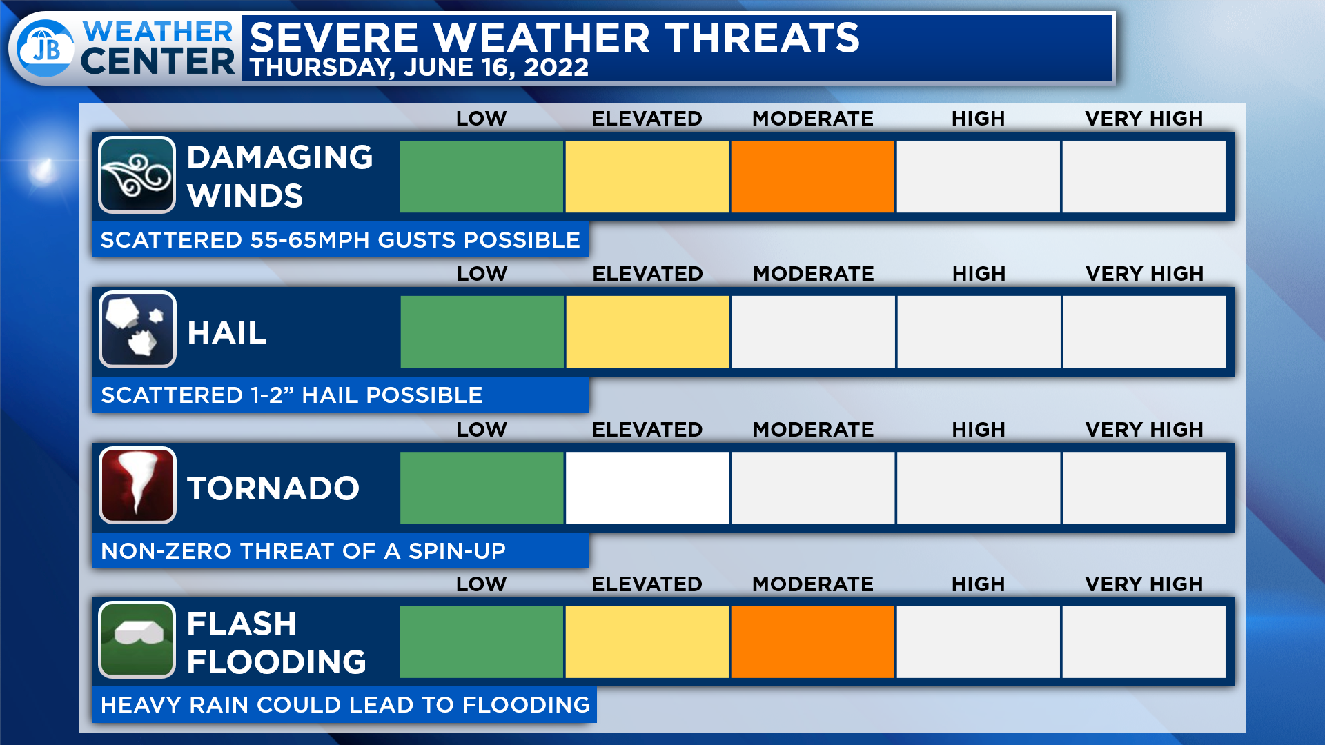
The main risk with this afternoon round would be damaging winds up to 65mph and large hail up to an inch or two. There is also a flash flooding risk with these storms as well. The morning round dropped up to half an inch of rain, or so, in some areas. An additional round of heavy rain could lead to some pounding.
There is also a non-zero threat of a weak spin-up tornado today. Granted, the greater threat of that will be northwest of DC. Nevertheless, all modes of severe weather are on the table, so any storm that does fire will need to be watched closely.
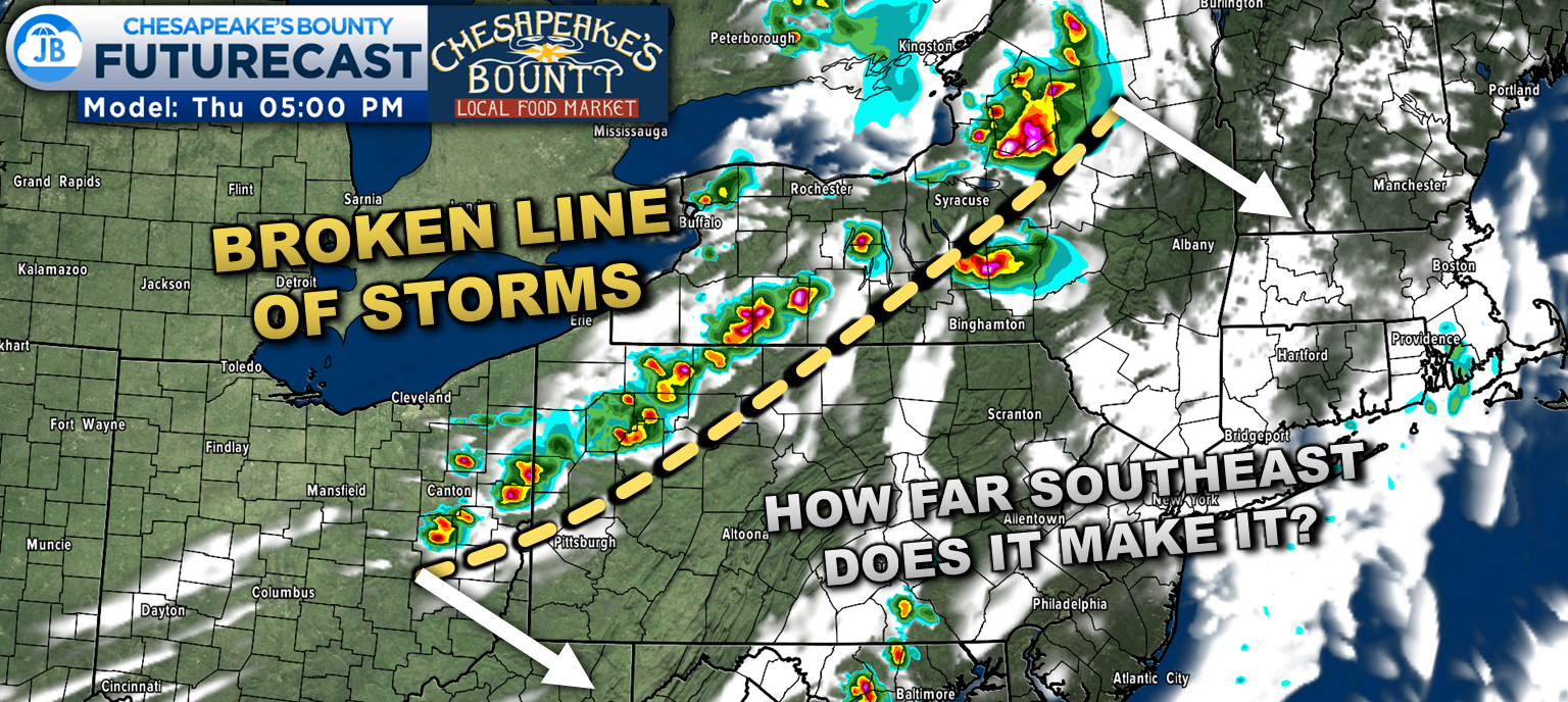
A more substantial line of thunderstorms is likely to fire this afternoon across western Pennsylvania and western New York State. This line is likely to bring numerous severe storms to that region. This line will sag southward throughout the afternoon, behind the storms that may push through locally.
It is unclear whether this line will make it down into our neck of the woods or not. It is likely to lose some punch as it moves southward and loses the peak heating of the day.
If it were to make it into this region, it would likely bring at least some severe threat to the MD/PA state line around sunset. It would then potentially bring a round of heavy rain to our region around 10/11pm tonight. But again, that is if it can survive the trip south and there is enough storm energy behind our afternoon threat. I’m skeptical if it can reach this far south, but it is something worth monitoring.
Remember that severe weather forecasting is far from a guarantee of anything. The goal of these forecasts is to alert you to the potential of storms, not a promise of storms.
Stay weather aware this afternoon and have a way to get weather updates and severe weather alerts. You can stay with JB Weather for the latest information on Southern Maryland weather. You can always access my forecasts and updates here on the website, on Facebook, on Twitter, on Instagram, and on YouTube.
-JB
Dr. Thomas Hao and Dr. Dylan Schneider offer comprehensive orthodontic services for all ages. Schedule your free consultation today. Visit www.SOMDBraces.com today for more information!
John Bordash
View More PostsJB Weather forecaster John Bordash is working around the clock to provide Southern Maryland, and neighboring communities, with accurate and reliable weather information.
1 thought on “AM Update: Upgraded to an Elevated Risk of PM Storms”
Comments are closed.
[…] AM Update: Upgraded to an Elevated Risk of PM Storms […]