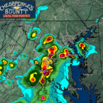
The Storm Prediction Center in Norman, OK has issued a SEVERE THUNDERSTORM WATCH for the Mid-Atlantic, including the following counties in our local coverage area:
- Anne Arundel (MD)
- Charles (MD)
- Prince George’s (MD)
- Calvert (MD)
- King George (VA)
- St. Mary’s (MD)
This watch is in effect until 9PM Saturday. Primary threats this evening are:
- Damaging wind gusts up to 65mph are likely
- Localized flash flooding.
SUMMARY: Initial severe threat will exist with slow-moving thunderstorms across central Virginia. Additional storms should develop from southeast Pennsylvania and central Maryland, spreading east towards the Mid-Atlantic coast through early evening.
PRECAUTIONARY/PREPAREDNESS ACTIONS: Remember, a Severe Thunderstorm WATCH just means that conditions are favorable for severe thunderstorms in and close to the watch area. People in these areas should be on the lookout for threatening weather conditions and listen for later statements and possible warnings. Severe thunderstorms can and occasionally do produce tornadoes.

It will be important to stay with JB Weather for the latest information on this severe weather threat and the impacts here in Southern Maryland. You can always access my forecasts and updates here on the website, on Facebook, on Twitter, on Instagram, and on YouTube. JB Weather is Southern Maryland’s Weather Leader, and I am working around the clock to keep you ahead of the storm!
-JB
John Bordash
View More PostsJB Weather forecaster John Bordash is working around the clock to provide Southern Maryland, and neighboring communities, with accurate and reliable weather information.