Brought to you by Cedar Point Federal Credit Union
Today will kick off a stretch of hot and humid weather that we have not seen that much of this summer. While the humidity has very much present, we are actually running below average for the number of 90-degree days we typically see. That will look to change this week, and it starts with today!

You want to make sure that you are taking this upcoming heat wave seriously. Temperatures are likely to be in the middle to upper 90s throughout the week, with the humidity remaining oppressive. You want to ensure that you are drinking plenty of water, trying to stay cool, and be mindful of your activity outside as well as the activity of vulnerable groups and your pets.
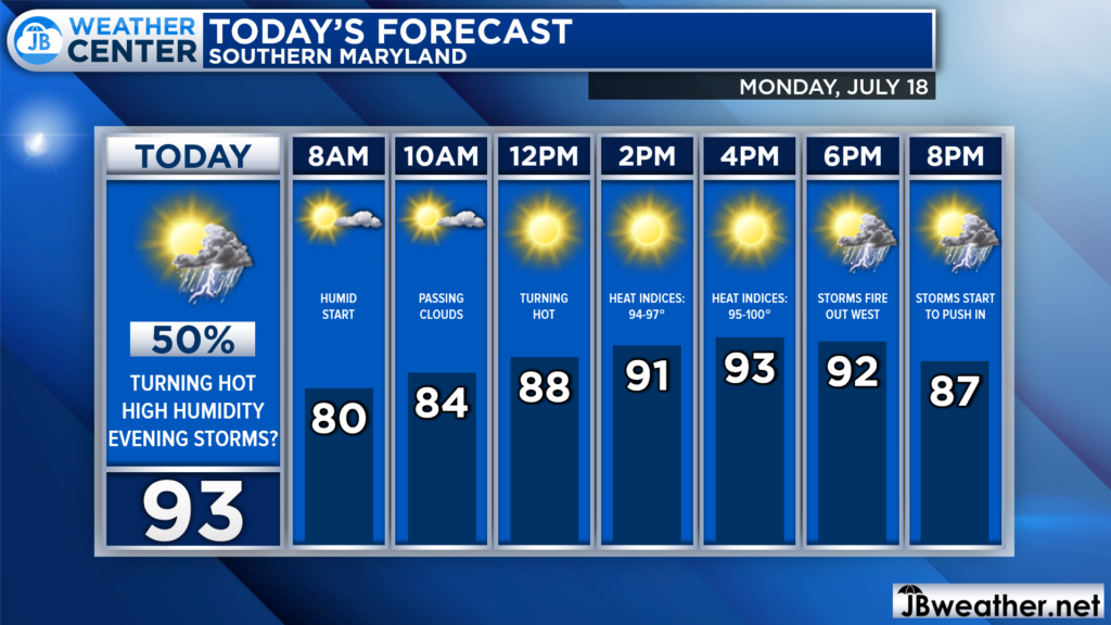
We are already off to a humid start with dewpoints in the lower 70s. Temperatures are still in the upper 70s, as well. This lays the groundwork for temperatures to soar this afternoon, likely reaching the 90s by early this afternoon. The humidity will make it feel like we are near 100°!
This hot and humid combination will allow for a decent amount of atmospheric storm energy to bubble over our region. The storm energy may allow for strong storms to push through this evening as as weak boundary moves across our region.
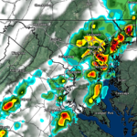
Our Futurecast model seems to have a good handle on today’s storm threat. We are likely to see storms initially fire up northwest of DC later on this afternoon, around rush hour. These storms will then slowly propagate eastward, towards I-95.
We will have to see how quickly these storms move. Futurecast does not have the storms approaching Southern MD until after sunset. However, I could see storms moving through as early as 5/6pm, given how hot and humid we will be.
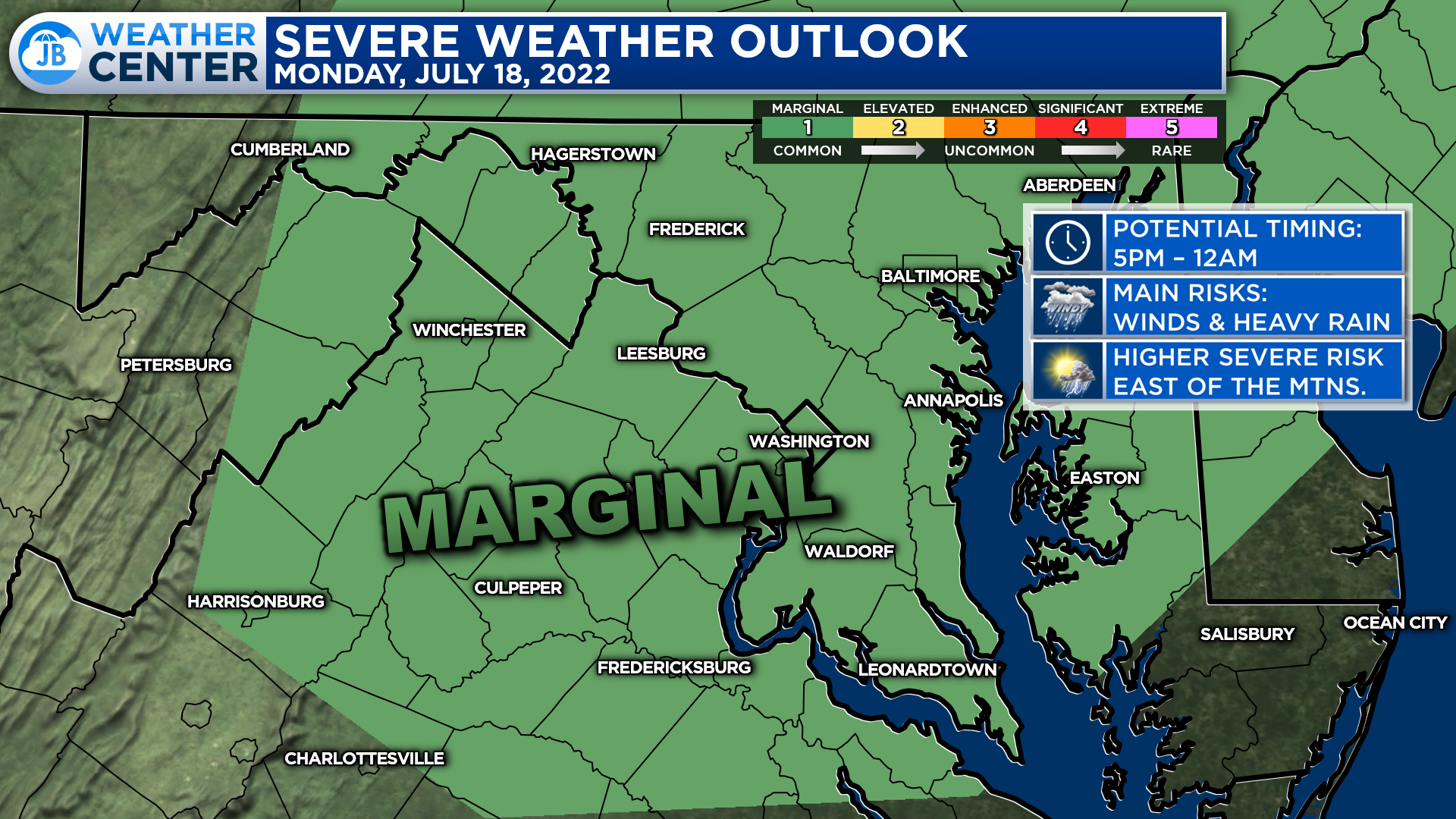
The Storm Prediction Center has placed our region under a Level 1 “Marginial Risk” of severe weather for this afternoon and evening. This means that storm development will be possible, with only 1 or 2 turning severe. Given today’s atmospheric setup, I would not be surprised to see this threat upgraded to a Level 2, at least for northern areas, in later updates.
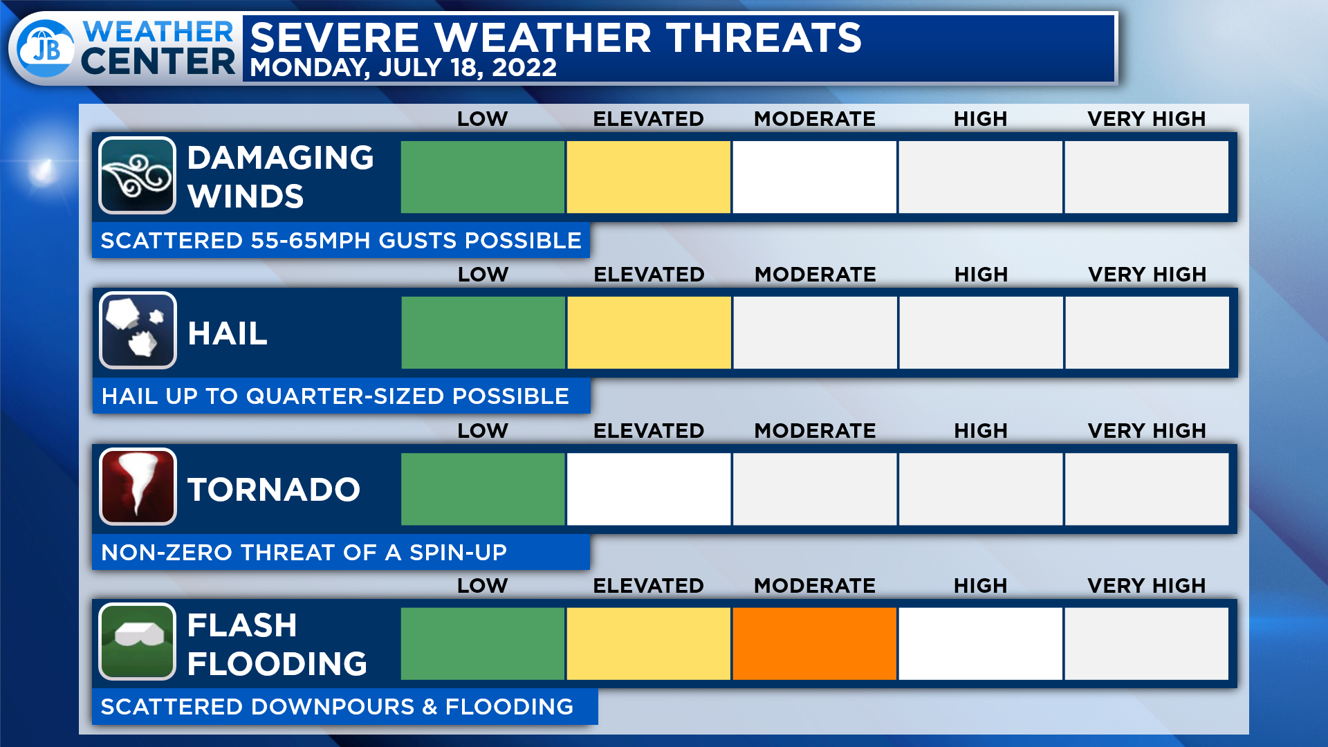
The primary severe weather risk with any storms that fire up will be the potential for storms to produce damaging winds up to 60mph and large hail up to 1″ in diameter. There is also a non-zero threat of a spin-up tornado. However, that threat seems to be the highest north of the Mason Dixon line.
There is also a notable threat of localized flash flooding today. Today’s storms should be moving at a good clip. However, they will be able to put down a quick inch or two of rain in a short amount of time. Over the last couple of weeks, we have seen storms bring parts of our region a lot of rain. This means that additional heavy rain could lead to localized flash flooding.
If you have outdoor plans this afternoon and evening, I would not cancel them. However, I would have water with you. And, I would recommend stay weather aware as hot and miss storms try to fire around lunchtime. Have a Plan B ready to go, and be ready to act if quickly-changing weather conditions move overhead.
Stay with JB Weather for the latest information on Southern Maryland weather. You can always access my forecasts and updates here on the website, on Facebook, on Twitter, on Instagram, and on YouTube.
-JB
Cedar Point has been providing trusted banking, lending and personal finance solutions to the Southern Maryland Community since 1945. Visit the credit union at any of its 6 locations in St. Mary’s, Charles and Calvert counties or online at www.cpfcu.com.
John Bordash
View More PostsJB Weather forecaster John Bordash is working around the clock to provide Southern Maryland, and neighboring communities, with accurate and reliable weather information.