Brought to you by William Richmond Inc.
Video version of the Winter Outlook
It’s hard to believe that we are already nearing another Winter season! It feels like just yesterday, we were tracking the big snowstorm in January 2022. This forecast was not an easy one to make. Diving into the science and piecing everything together has kept me busy for the last couple of weeks! So, let’s dive right into it!
I have published nine Winter outlooks since JB Weather began. It should go without saying, but seasonal forecasting is notoriously hard. People joke that weather forecasters struggle enough to produce 7-day forecasts, so we should avoid seasonal forecasting. The purpose of these sorts of projections is to provide you with general ideas of what to expect.
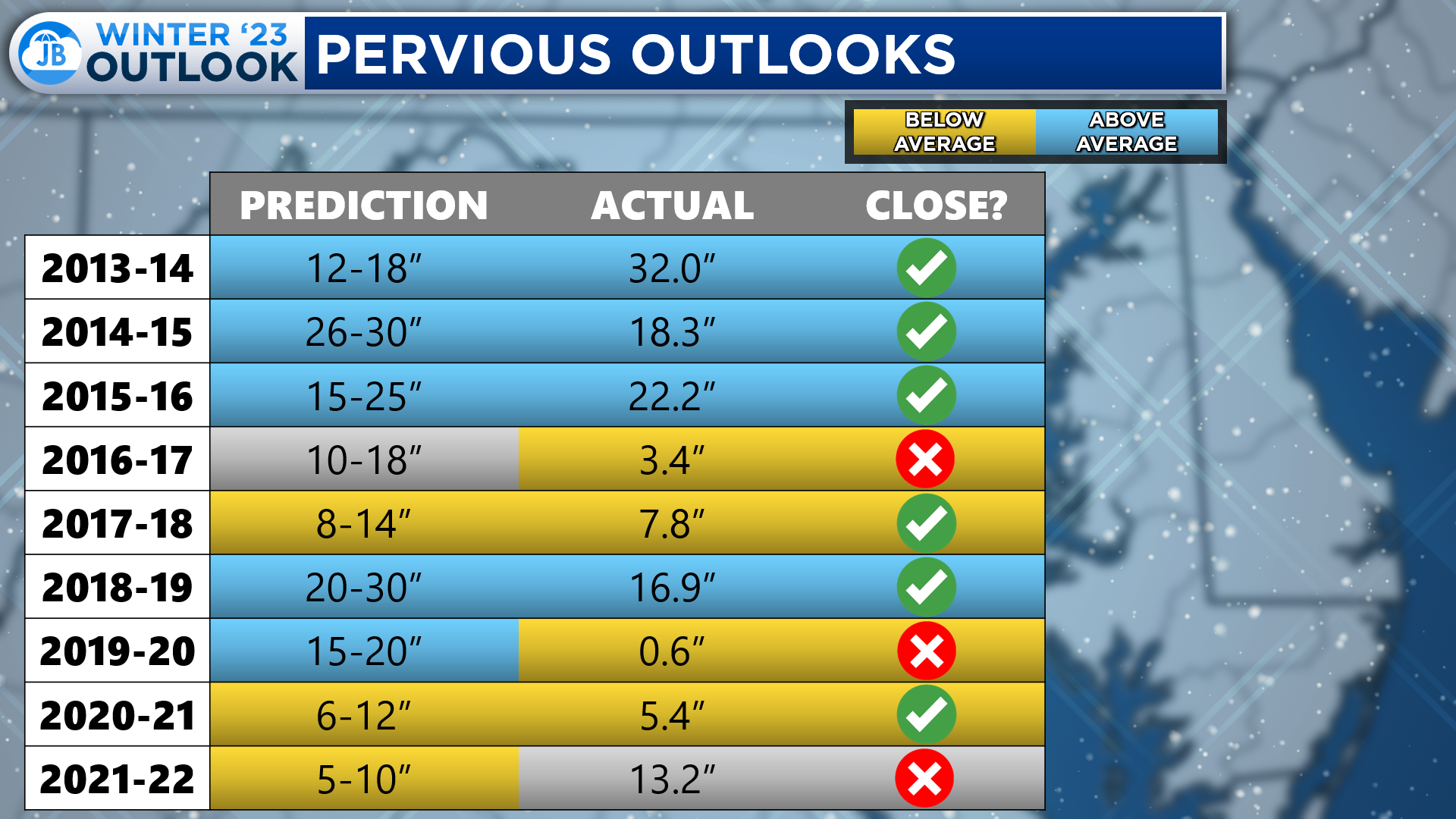
To put together this chart, I analyzed the data at DC’s Reagan National Airport, the closest official reporting site to Southern MD. For each Winter, I looked at the amount I forecasted for DC, the amount that fell, and then determined whether those values were above or below average. The seasonal average at DC’s Reagan National is 13.8″ When looking at my snowfall seasonal predictions, 6 of my 9 forecasts have produced somewhat accurate results.
Clearly, some seasonal forecasts are better than others. Last Winter, I forecasted for our region to see 5-10″ of snow. Mother Nature had different plans, though! On January 3rd, 2022, we saw a last-minute storm materialize and dump 10-15″ of snow on our region. This storm blew my winter forecast out of the water in what was otherwise a typical Winter. What will this Winter hold, though?!
The Science
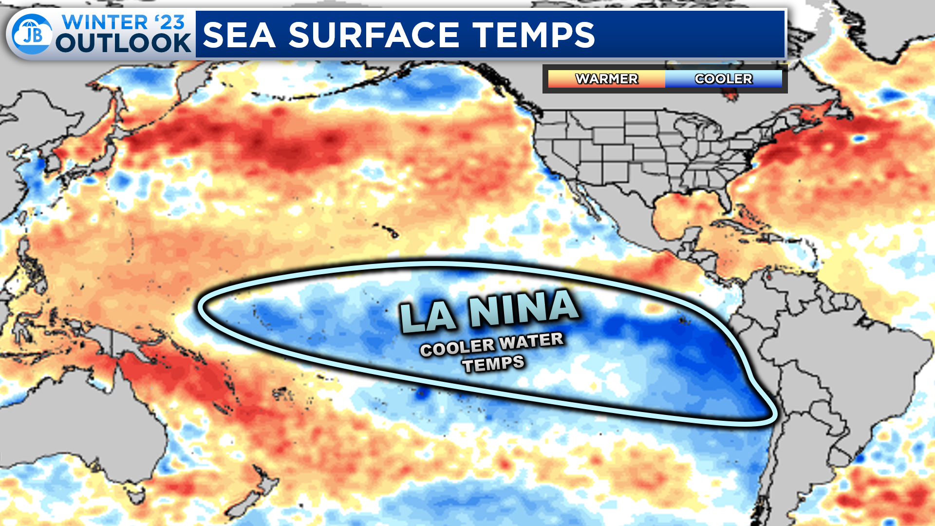
To accurately predict what we see, we need to look at what is happening in the Pacific Ocean. The sea surface temperatures in the Pacific significantly impact our weather here in North America. This winter, for the third straight year, we have cooler-than-average water temperatures in the Equatorial Pacific Ocean, a phenomenon known as La Nina.
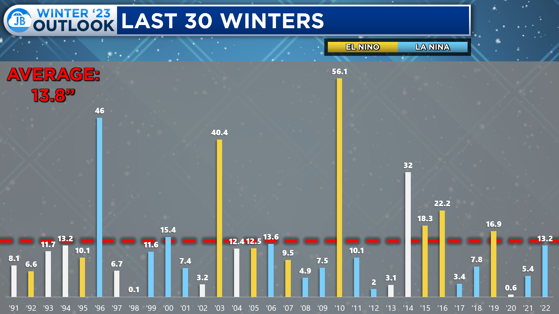
Over the last 30 years at DC’s Reagan National Airport, La Nina winters, shaded in blue, tend to produce average to below snowfall. Meanwhile, most of our above-average snowfall winter occurs in an El Nino state, when warmer waters are in the Equatorial Pacific Ocean.
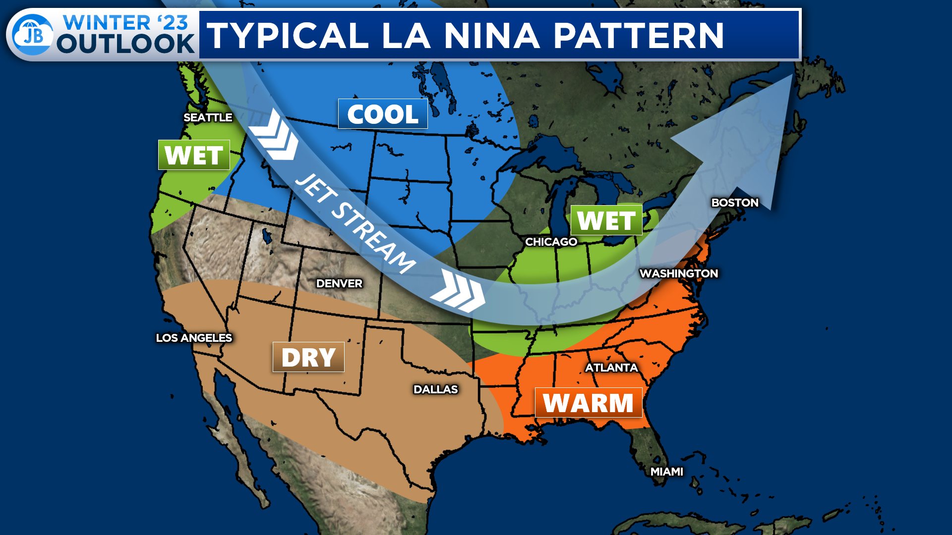
Typically in a La Nina winter, the weather pattern favors the presence of one strong northern Jet Stream. This Jet Stream usually would set up across the northern US, featuring colder conditions to its north with wetter than average conditions along it as it would serve as the primary storm track. The southern US typically sees warmer and drier conditions in La Nina winters.
While this may be the typical La Nina set up, I am not sold that this will happen–at least, not all winter. The La Nina is posed to weaken throughout the winter. We also have the presence of another feature in the Pacific…
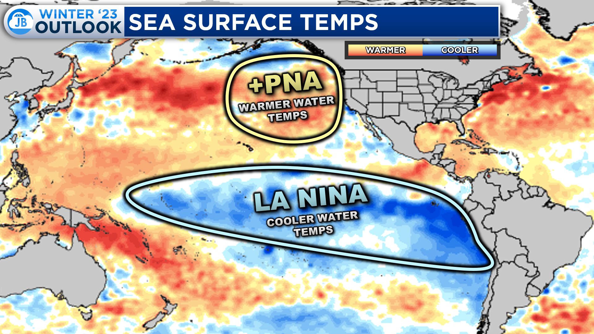
In addition to the La Nina, which should weaken throughout the season, we also have the presence of a “positive PNA”. This positive PNA refers to the warmer water temperatures off the US West Coast. These warmer waters can help reconfigure the northern Jet Stream, allowing cold air to dip further south over the eastern US. This setup could lead to snowier and colder-than-average conditions west of the Mississippi.
Winter Outlook
So, what do I expect this winter? Let’s start with the general outlook for winter’s first and second halves.
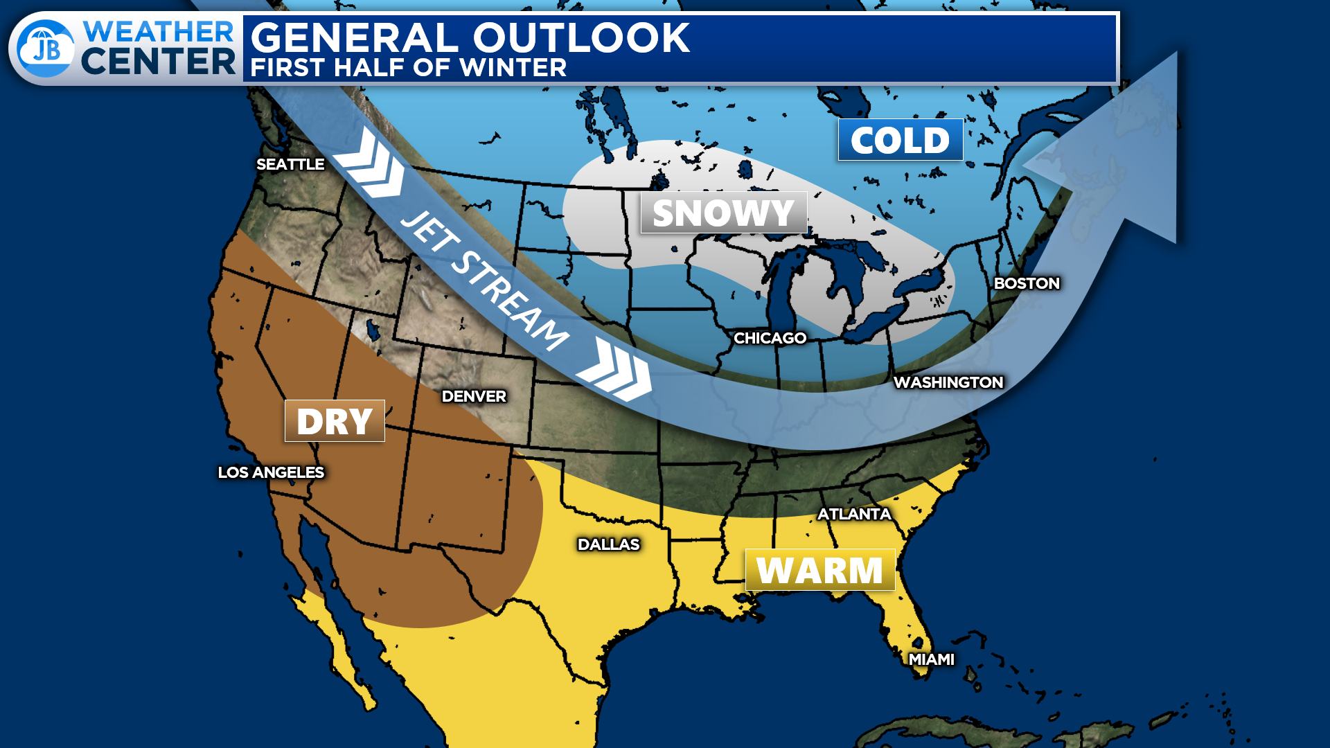
First Half
During the first half of the winter, we will likely see only one Jet Stream dominate our pattern. This Jet Stream to the north will help to bring cold and snowy conditions across the northern US. Conversely, the southern US will likely see warm and dry conditions. We will probably be caught between these two options here in the Mid-Atlantic. Thanks to the +PNA, we should see the Jet Stream be allowed to dip southward at points in November and December and deliver colder air shots. This Jet Stream dip could let snow break out across the Mid-Atlantic and East Coast early–potentially before Christmas.
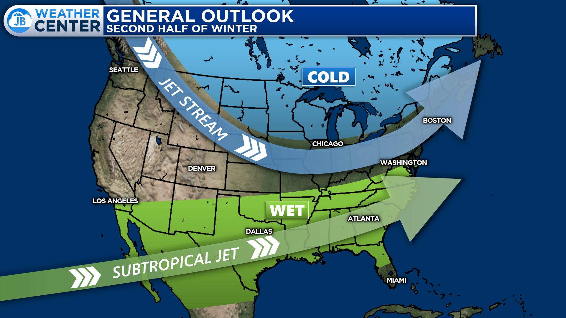
Second Half
La Nina will likely fade away as we head into the second half of the Winter. The La Nina fading would allow for a southern Subtropical Jet Stream to develop. The Subtropical Jet Stream would act as a railroad track for southern systems to develop and push eastward. This should allow for wetter conditions to return to the southern US. The Jet Stream should remain pressed to the north, as it was early in Winter. However, we could see a few dips in the northern Jet Stream, like in the first half of Winter. If we could time a Jet Stream dip with a southern storm, we could see a late-season wintry event. But it remains to be seen if this will happen. We would need that Subtropical Jet Stream to get its act together.
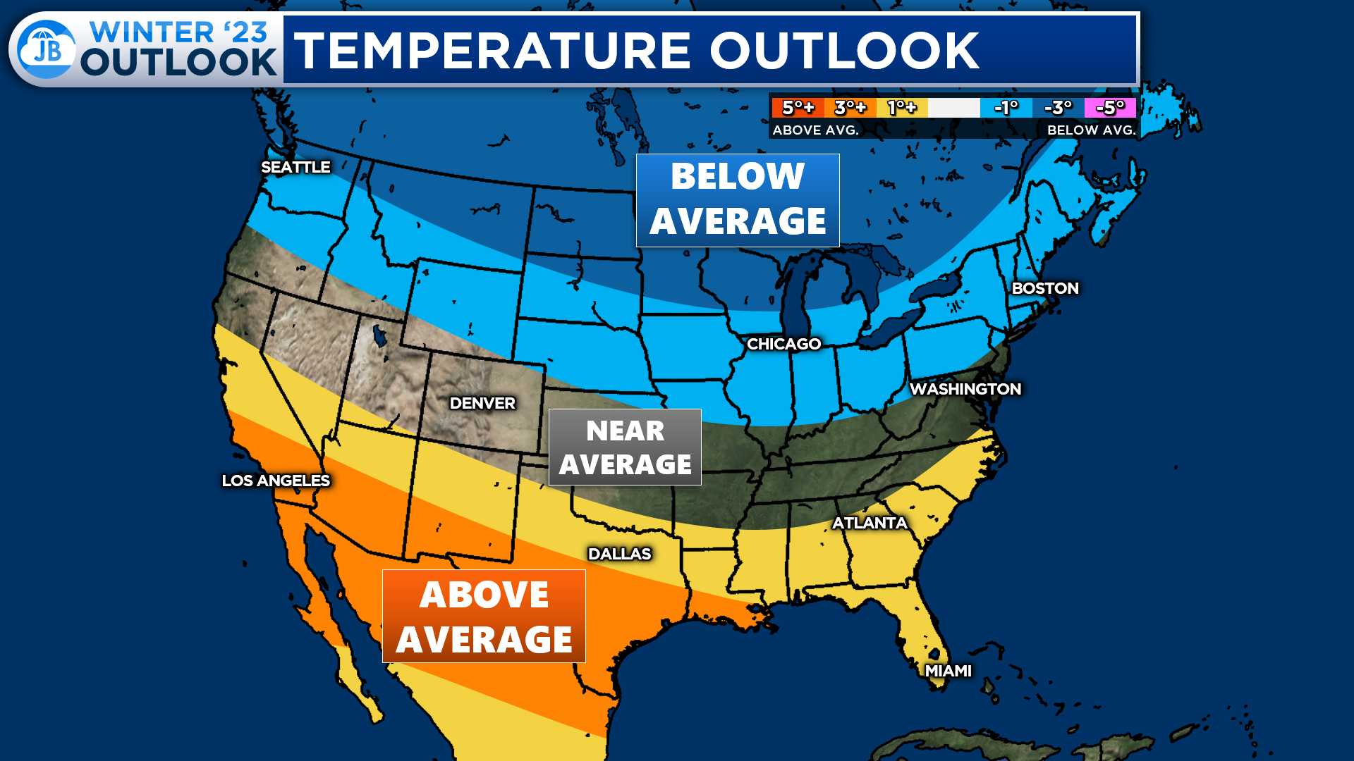
When it comes to temperatures for the winter as a whole, I expect below-average temperatures for the northern tier of the United States. This is thanks to the setup of the northern Jet Stream, consistently allowing cold air to impact these regions. Since the Jet Stream will pushed northward, I expect above-average temperatures across the southern United States. Our area is likely to be caught between these two zones, thanks to the variability of the northern Jet Stream. I expect temperatures to be within a degree or two of average in the Mid-Atlantic. Compared to last winter, this will feel colder!
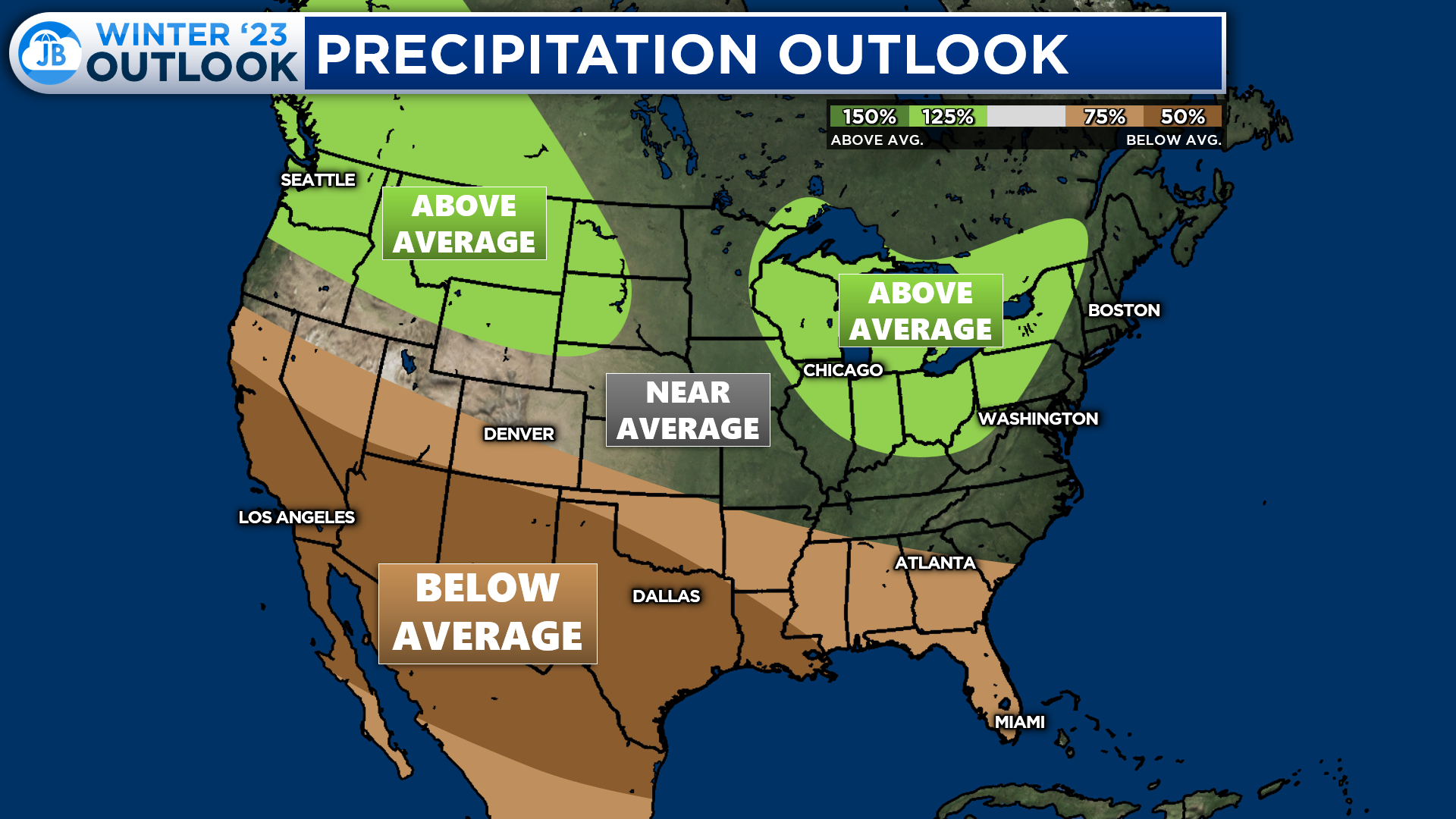
Regarding precipitation, northern areas will once again be favored for above-average values. This is not looking at rain or snow but the liquid precip values of both. The placement of the Jet Stream is likely to promote frequent systems impacting the Pacific Northwest and the Great Lakes. The southern US is expected to see below-average precipitation. This will be especially true if the Subtropical Jet Stream does not get its act together to allow for southern storms. In the Mid-Atlantic, I expect near-average precipitation with above-average precip in the Mountains.
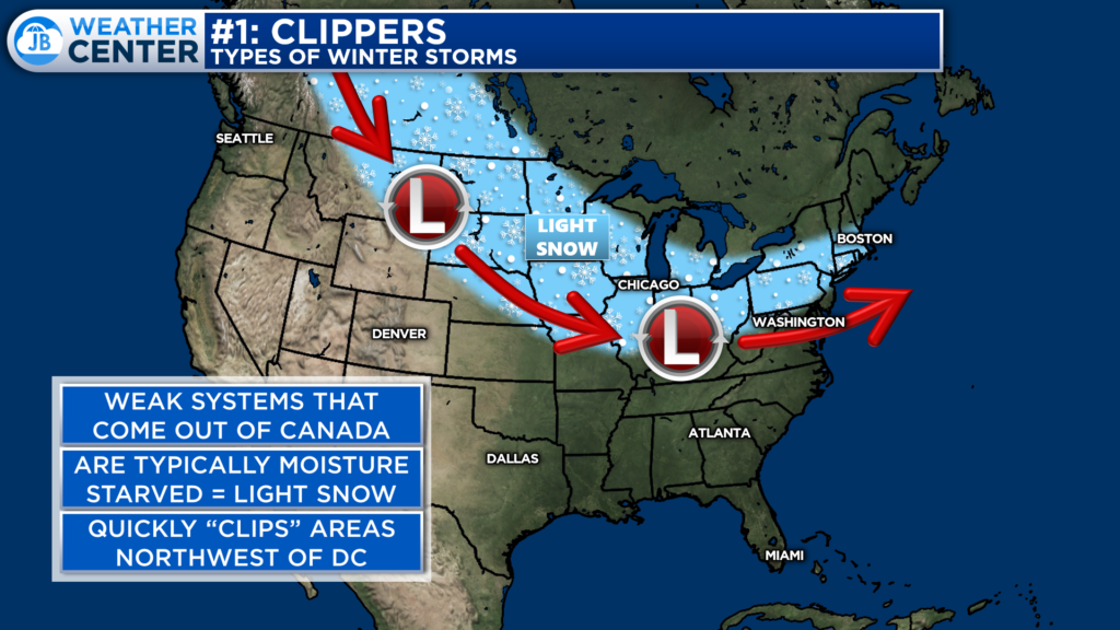
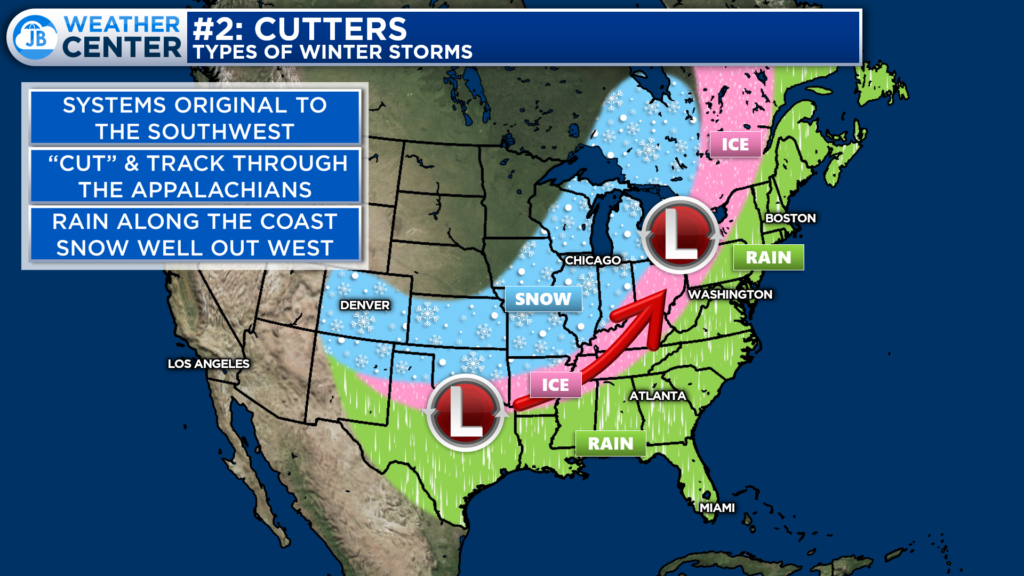
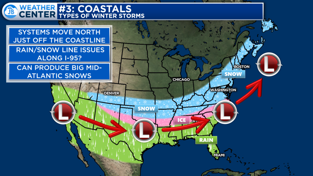
This winter, I expect us to see 3 primary storm tracks. I call them the 3 C’s:
- Clippers: These are fast-moving, weak systems that dive southward out of Canada. These little guys “clip” the northern US with a quick bout of light snow. These typically don’t deliver more than a couple of inches of snow. These only affect areas north of our region, but we can manage a minor coating to an inch of snow out of these in the Mid-Atlantic.
- Cutters: This will be the predominant storm type I expect to see this Winter. These systems develop to the south and track, or “cut” to our west through the Appalachian Mountains. These systems can bring big-time snows to the Midwest. These systems can also bring ice to the mountains and the East Coast. With a decent number of Cutters expected this Winter, there is an increased ice threat.
- Coastals: The last storm type is a famous one for our region! Coastal systems can produce some of the most significant snows in the Mid-Atlantic. These southern sliding systems can bring plenty of moisture to the area while we have cold air locked in. Depending on how close to the coast these track are, we can deal with rain/snow line issues here in Southern MD with these.
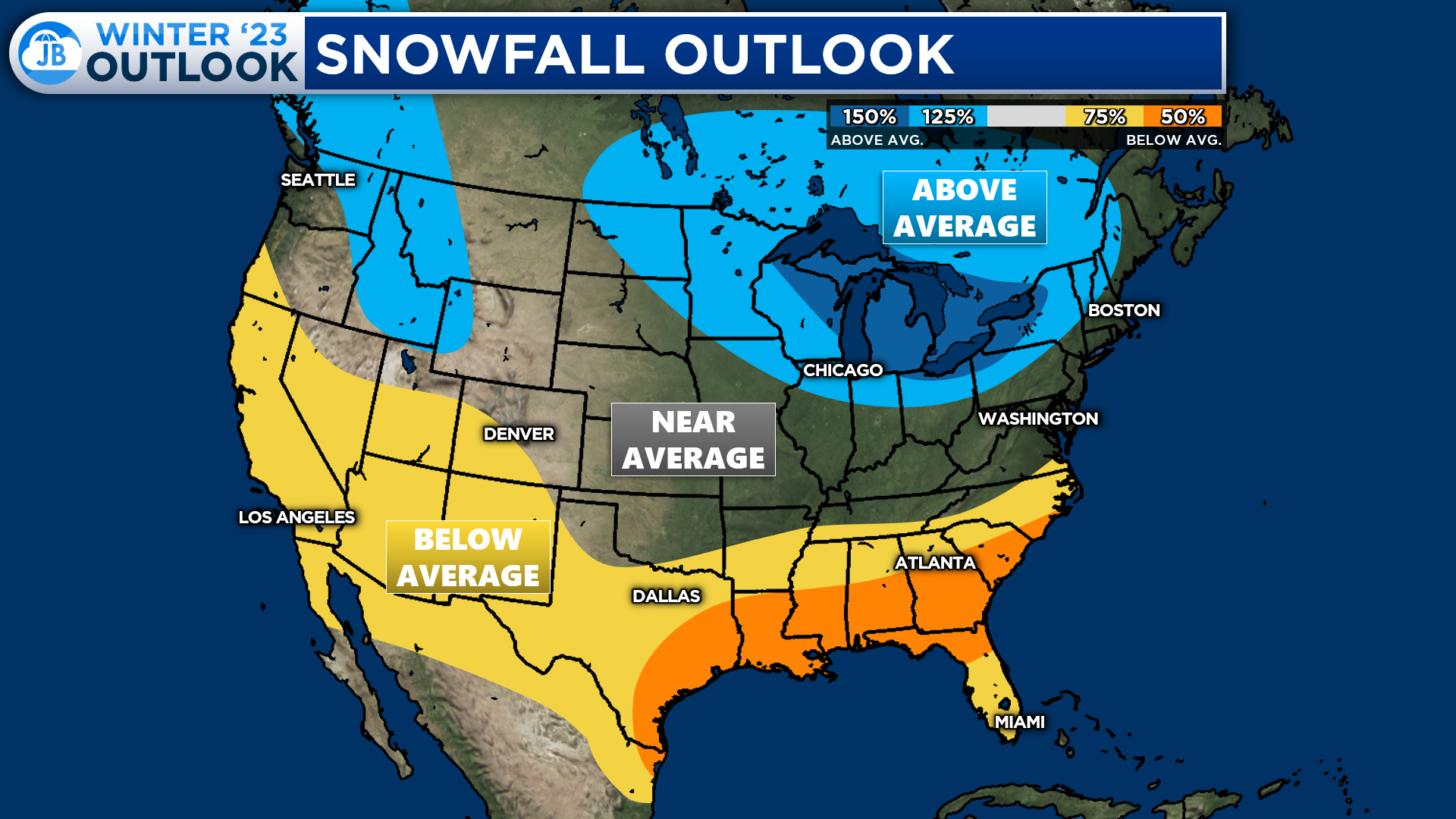
We should see a decent number of Clippers and Cutters this winter. This setup will favor above-average snowfall across the northern US, especially around the Great Lakes. Since the Subtropical Jet Stream is likely to get going a touch too late, at the end of the season, I expect below-average snowfall for the southern US. With that said, I do expect at least one coastal system. This should allow the Mid-Atlantic to get near average in regards to snowfall.
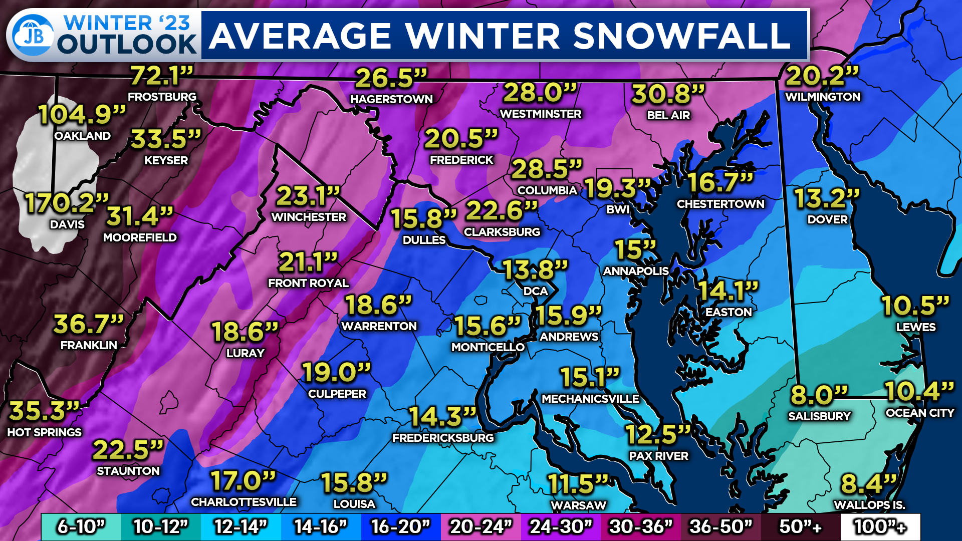
Average snowfall in the Mid-Atlantic varies greatly. Coastal areas typically see between 6-12″ of snow in a typical winter. Southern MD, on average, sees between 12-16″ of snow, with more snow falling the further away from the water you get. Areas northwest of DC, on average, see nearly two feet of snow. The mountains can pick between 50-100″+ of snow in the winter!
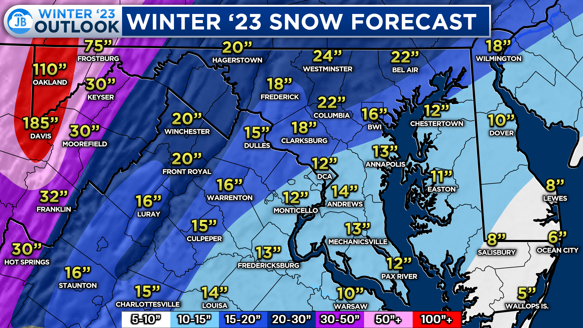
With this in mind, this is what I expect this winter. In Southern MD, I think between 10-15″ of snow is likely for most. This is right around our seasonal average and close to what we saw last year. This winter’s most noticeable difference is that I do not expect this to come all at once. We will see a few smaller systems, and potentially one more moderate system, impact the region and get us to these numbers. More will be found to the west. The mountains may end up with slightly above-average snowfall!
Summary
Putting everything together, here is what I expect this winter.
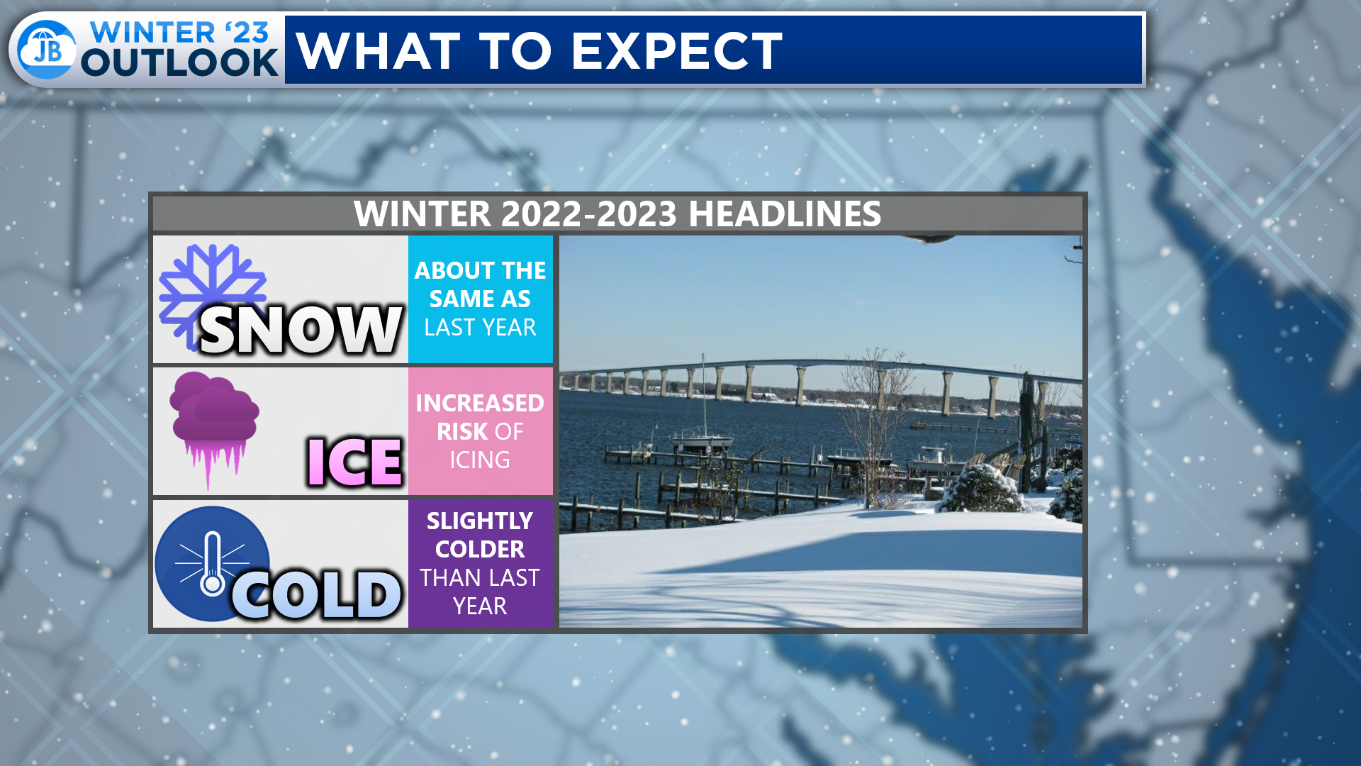
- I expect about the same amount of snow as last year. With that said, I do not expect it to come all at once like it did last year. Instead, we will see smaller events throughout the winter.
- Winter is likely to get off to a fast start! We could see cold and snow outbreaks as early as late November and December this winter. The pattern should moderate some during the second half of the winter, but that is when we may see a more moderate-sized wintry system impact our region.
- Given that the Cutter storm track will be favored this winter, we have an increased risk of icing events this winter. Our region may see 1-2 icing events this winter.
- This winter will feel slightly colder than it did last winter. However, temperatures this winter will likely be around average. However, this winter will probably feel colder than last winter, especially early on.
Stay tuned to JB Weather through the winter season for the latest Mid-Atlantic winter weather information!
-John A. Bordash

Shelter your Maryland home with a strong roofing, siding, window, or gutter system. Call (443) 432-3426 or check out williamrichmondinc.com today!
John Bordash
View More PostsJB Weather forecaster John Bordash is working around the clock to provide Southern Maryland, and neighboring communities, with accurate and reliable weather information.

3 thoughts on “Exclusive Winter 2022-23 Forecast”
Comments are closed.
Amazing job breaking it down for everyone. The science is impeccable, the logic is easy to follow and your dedication is greatly appreciated. Thank you JB, for the great service you provide to Southern Maryland.
Thanks a bunch from a new reader. I appreciate your time, skill and generosity.
Hi John,
Do you work in the sunspot cycle into your predictions?