The tropics are beginning to wake up in a big way. Tropical Storm Humberto has formed south of Bermuda and is expected to curve safely out to sea by the weekend, posing no direct threat to the U.S. East Coast. The more complicated piece of the puzzle is a developing low-pressure area near the Bahamas, which is increasingly likely to become Tropical Storm Imelda within the next few days. Early model guidance shows a wide range of possibilities, and the long-term track remains highly uncertain.
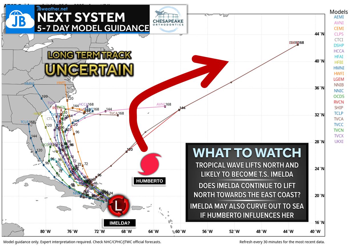
One of the biggest questions is whether Humberto will influence Imelda’s future path. If the spacing and timing between the two storms line up just right, Humberto could “grab” Imelda and help pull her out to sea—similar to how one storm can interact with another in classic Fujiwhara-style setups. But if Humberto moves too quickly, Imelda could be left behind in a region of weak steering currents, opening the door for a potential track toward the Southeast U.S. instead. As always with tropical systems, small shifts early on can dramatically change the final outcome.
At this stage, nothing is set in stone, and confidence in any single track scenario is low. The Bahamas, Florida, and the Southeast Coast should monitor updates, but it’s far too early to sound alarm bells. There is still a real chance Imelda turns north and bends harmlessly into the Atlantic, especially if Humberto exerts enough influence. Conversely, if Imelda remains disconnected from Humberto, she could become a more direct concern for the U.S. coastline late next week. This is why long-term hype can be misleading.
And yes—this would be the “I” storm of the season, notorious in recent decades for producing impactful hurricanes. That does not guarantee anything here, but it’s another reason to stay aware and follow reliable, level-headed updates over the next week. I’ll be tracking the trends closely and will keep you updated as the picture becomes clearer. For now, stay tuned and avoid the hype machine.
John Bordash
View More PostsJB Weather forecaster John Bordash is working around the clock to provide Southern Maryland, and neighboring communities, with accurate and reliable weather information.