We are now within 24 hours of the Mid-Atlantic’s first winter storm of the season. After parsing through all of the latest data and short-range guidance, I am ready to make my final call on this storm. Our latest guidance is suggesting the timing may be a bit quicker and that there may be a northwest shift with this storm, but the overall story remains the same: a classic early-December setup with a sharp gradient between accumulating snow to the north and mostly rain to the south.
TIMING
Snow and sleet will begin entering the Shenandoah Valley between 2–3 AM, arrive in the DC/Baltimore corridor around 3–4 AM, and reach southern Pennsylvania between 4–5 AM. Inland areas will start as snow or a snow/sleet mix before warmer air pushes in aloft. The window for wintry travel concerns is before sunrise through mid-morning north and west of I-95. Closer to the metro regions, a fast transition to rain will limit winter impacts but still lead to a slow, soggy commute. All precipitation should come to an end by early-to-mid afternoon.
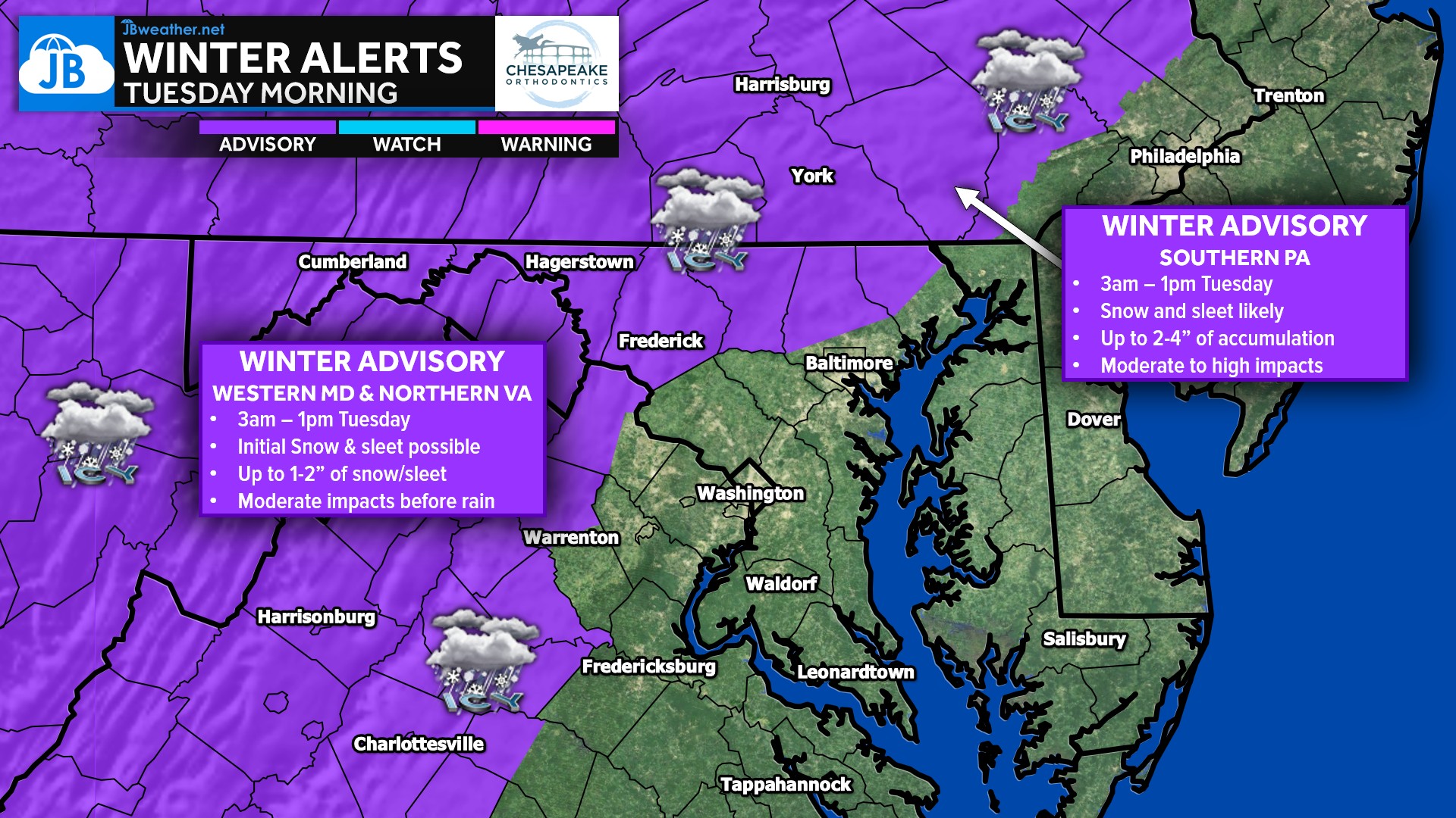
A Winter Weather Advisory is in effect for the areas northwest of I-95, including western Maryland, northern Virginia, and southern Pennsylvania. These are the regions cold enough to see several hours of snow and sleet before the changeover to rain, leading to slick roads and moderate early-morning impacts. This aligns closely with where the highest snowfall totals and the greatest disruption are expected.
FORECAST MAPS
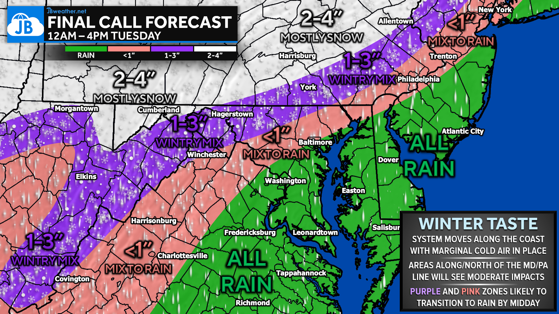
Snowfall amounts tightly reflect this warming temperatures we will see. Areas north of Route 30 in PA are locked into the coldest profile longest, allowing 2–4 inches of mostly snow before mixing arrives. Between Route 30 and the Maryland border—stretching through southern PA, eastern WV, and dipping into parts of Frederick County, MD—expect 1–3 inches of snow and sleet before a mid-morning transition to rain. Just northwest of I-95 (portions of Carroll, northern Montgomery, northern Howard), less than 1 inch is expected, and the switchover will happen quickly. The I-95 corridor itself may see a brief burst of sleet but will spend the majority of the event in rain.
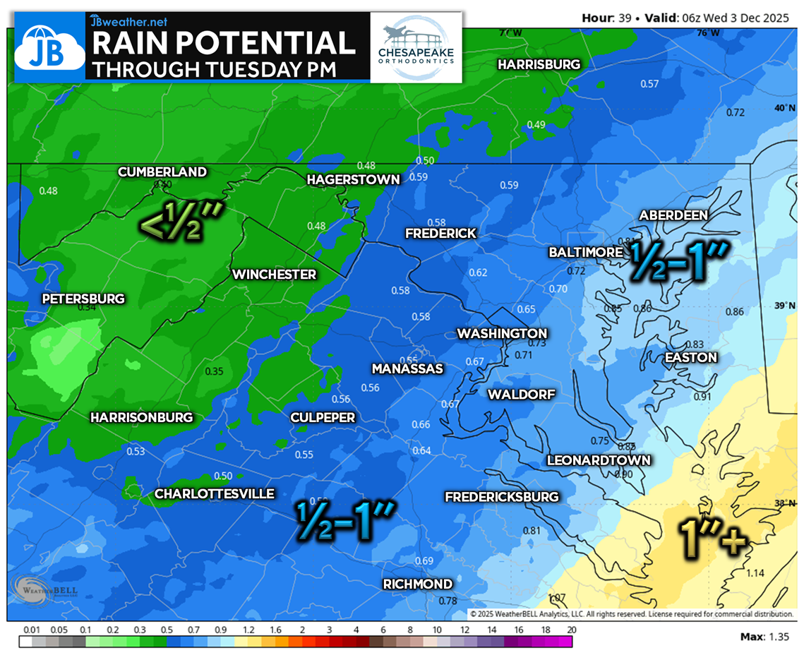
Southeast of I-95, it’s an all-rain event with up to 1 inch of cold rainfall by midday.
IMPACTS & SCHOOL ODDS
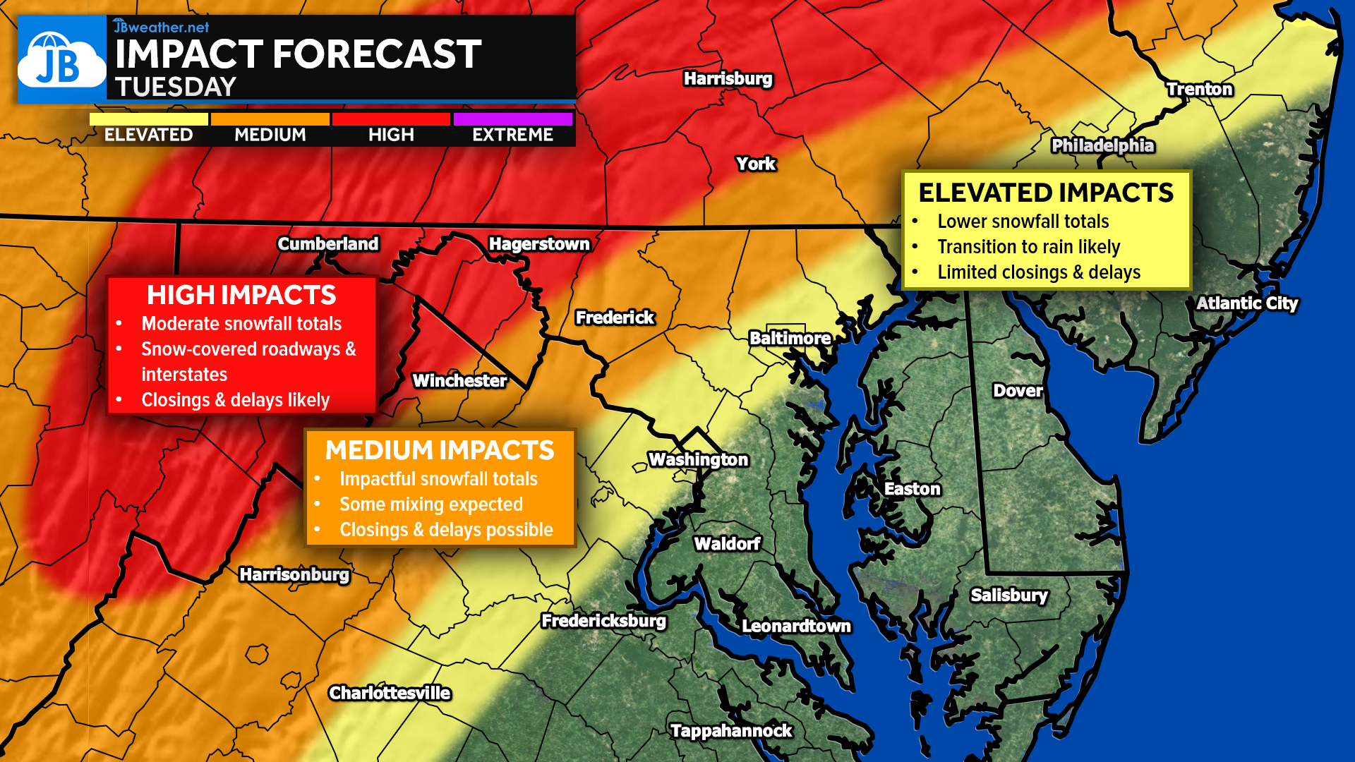
Impact levels mirror the snowfall gradient. High impacts are likely in southern PA, western MD, and parts of eastern WV where snow may briefly cover roads and delays/closings are most likely. Medium impacts stretch from Route 30 to the state line and through Frederick County, where a few inches of snow and early mixing could lead to slick conditions and possible delays. Elevated impacts cover the I-95 corridor, where the commute is wet and slow but not overly hazardous. Southeast Maryland sees low winter impacts with mainly rain.
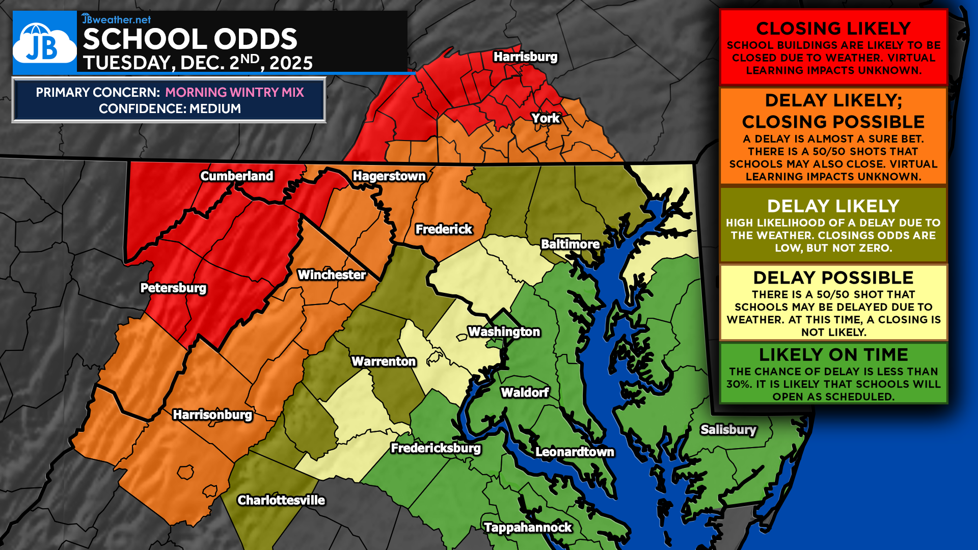
School odds follow the same trend:
• Closings likely north of Route 30 in PA.
• Delays likely along the Mason-Dixon Line.
• Delays possible for central MD and the metro suburbs.
• Likely on time southeast of I-95.
I’ll continue monitoring our latest short-range data through the night. Stay with JB Weather for the latest information on impacts here in Southern Maryland and across the Mid-Atlantic. You can always access my forecasts and updates here on the website, on Facebook, on Twitter, on Instagram, and on YouTube. JB Weather is the Mid-Atlantic’s Weather Leader, and I am working around the clock to keep you ahead of any storm!
John Bordash
View More PostsJB Weather forecaster John Bordash is working around the clock to provide Southern Maryland, and neighboring communities, with accurate and reliable weather information.


1 thought on “Final Call: Tuesday Morning Wintry Mess Incoming”
Comments are closed.
Thank you