Brought to you by Chesapeake Orthodontics
After today’s storm delivered a wintry mix of snow and sleet to our northwestern zones and more than an inch of rain to southeastern areas, our attention quickly shifts to the next system on the horizon. A weak low is expected to develop across the Deep South late this week while a strong high-pressure system drops into the Northeast, sending a fresh injection of cold air into the Mid-Atlantic.
As forecast in the Winter Outlook, winter was likely to get off to an active start, and it appears that we are seeing just that!
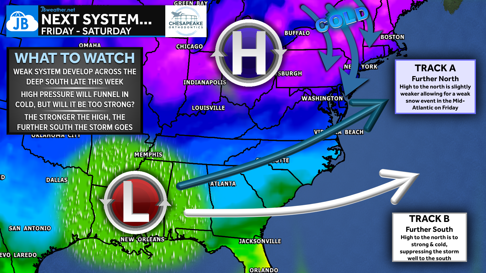
By Friday and into the weekend, temperatures will be locked in the 30s, running nearly 20 degrees below average for early December! This surge of cold air is being driven by that high pressure to the north, but its strength will dictate the entire setup. A stronger, faster-developing high would suppress the southern system well to the south with little to no impact locally. A slightly weaker or slower-developing high, however, would allow the storm to nudge a bit farther north and potentially spread a stripe of light snow across parts of the southern Mid-Atlantic later Friday.
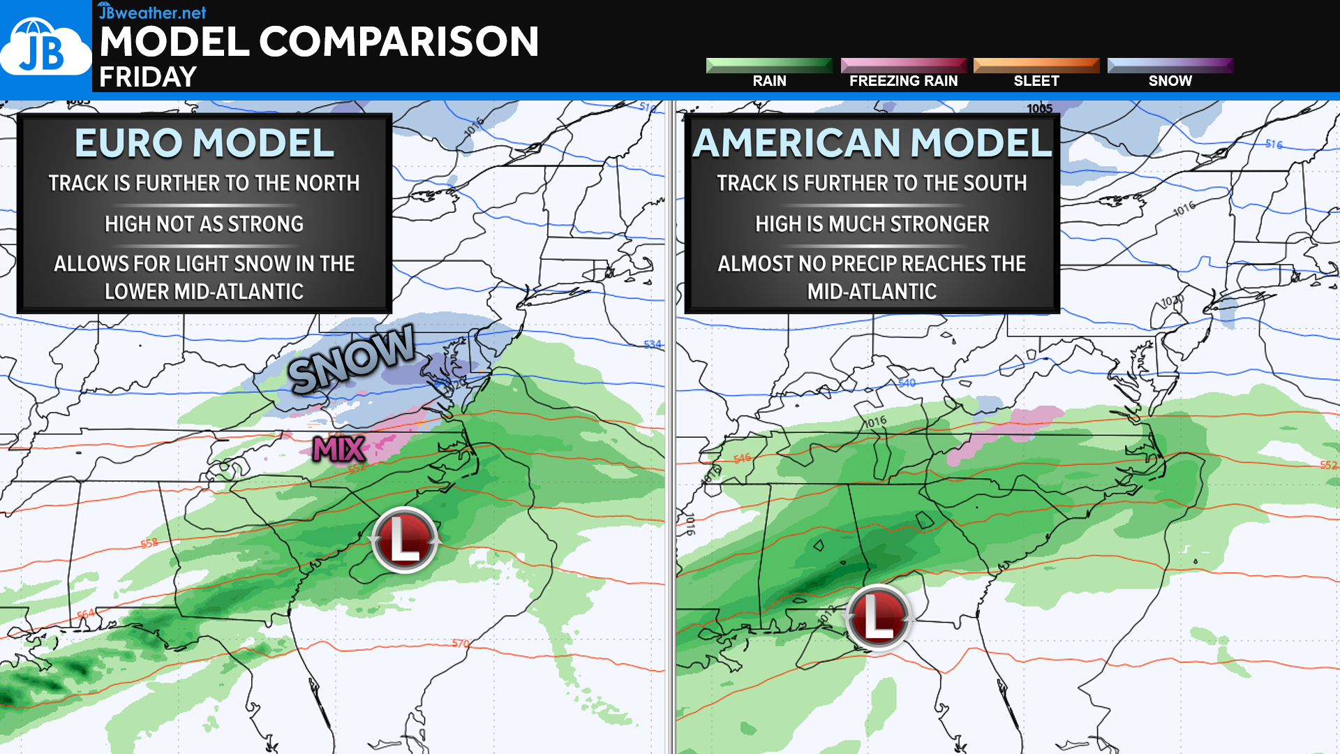
Our model guidance highlights this exact tug-of-war. The European model favors a track farther north thanks to a weaker high-pressure system, which would allow moisture to reach into the Mid-Atlantic and potentially bring light snow on Friday. The American model, however, is stronger with the high and pushes the storm much farther south—resulting in almost no precipitation reaching our region. Historically, the Euro tends to handle these setups better, but it’s worth noting that the American model actually outperformed the Euro with today’s storm. This model split is a good reminder that even 3–4 days out, it’s too early to lock in on any one solution.
Regardless of the exact track, this system is not signaling a major storm. Moisture is limited, and the cold high to the north may suppress most of the activity. Still, the ingredients are close enough that small changes in the high’s strength or placement could shift the final outcome by 50–100 miles. Those details should come into clearer focus by midweek!
For now, expect colder-than-normal conditions heading into the weekend and stay tuned to JB Weather for updates as we get a better sense of how this high–low interaction evolves. You can always access my forecasts and updates here on the website, on Facebook, on Twitter, on Instagram, and on YouTube. JB Weather is the Mid-Atlantic’s Weather Leader, and I am working around the clock to keep you ahead of any storm!
Dr. Thomas Hao and Dr. Dylan Schneider offer comprehensive orthodontic services for all ages. Schedule your free consultation today. Visit www.SOMDBraces.com today for more information!
John Bordash
View More PostsJB Weather forecaster John Bordash is working around the clock to provide Southern Maryland, and neighboring communities, with accurate and reliable weather information.
1 thought on “Looking Ahead: Another System to Watch Late Week”
Comments are closed.
[…] Looking Ahead: Another System to Watch Late Week […]