A fast-moving winter system will impact the region tonight into early Sunday, with timing now a bit faster than earlier forecasts. Rain and snow showers will quickly transition to all snow northwest of I-95 this evening, with snow spreading southeast overnight before tapering off early Sunday morning.
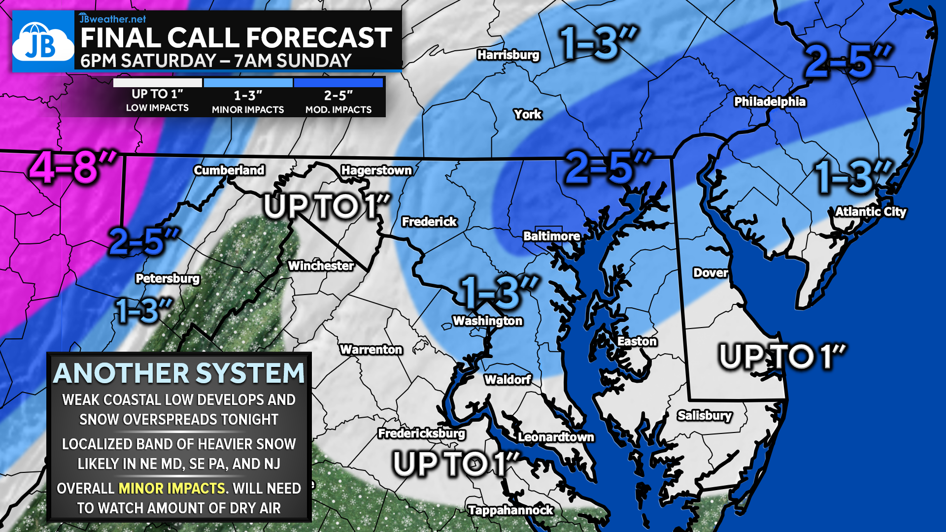
Snowfall totals will be light for most areas, with 1–3″ expected along the I-95 corridor. A narrow band of more moderate snow is likely to develop across northeast Maryland, southeast Pennsylvania, and New Jersey, focusing on Philadelphia and northeast of Baltimore. In this zone, 2–4 inches are likely, with localized amounts up to 5 inches possible where banding persists. Higher totals will also continue across the mountains.
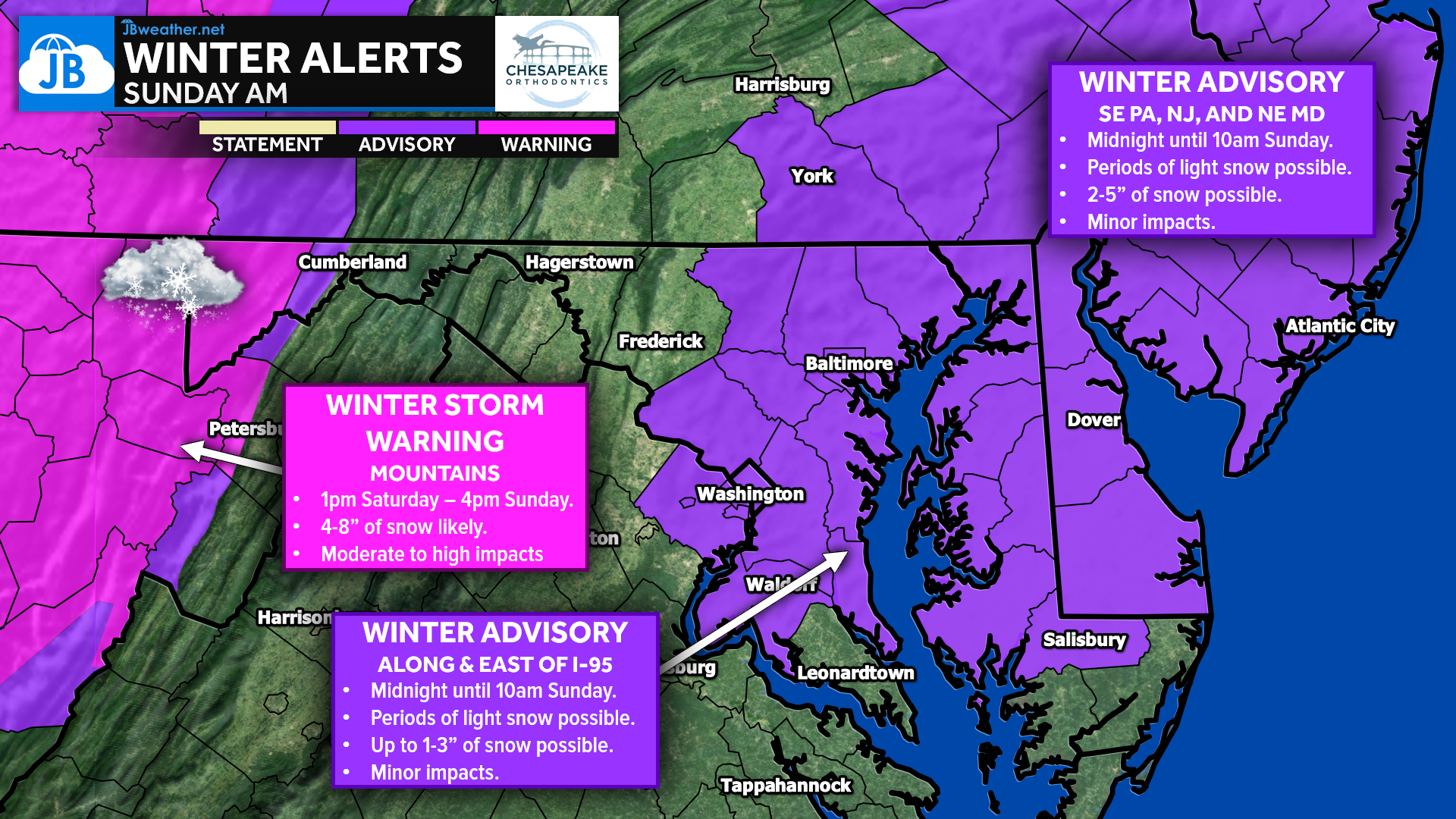
Winter Weather Advisories remain in effect along and northeast of I-95, where confidence is highest for accumulating snow. Areas south of US-50 may see lighter precipitation rates and slightly warmer temperatures, which could limit accumulations. Overall, minor impacts are expected, but roads will become snow-covered overnight, making Sunday morning travel potentially slick, especially in advisory areas. Moderate impacts remain possible where higher totals occur to the northeast.
The FutureView model highlights the southeast progression of snow overnight, along with the potential for dry slotting, which could lead to sharp snowfall gradients over short distances. This remains the main uncertainty with this system. Behind the snow, very cold air rushes in, with highs stuck in the 20s Sunday, lows falling into the teens Sunday night, and wind chills dropping into the single digits and even below zero northwest of I-95.
KEY TAKEAWAYS
- ⏰ Timing: Snow develops this evening, peaks overnight, and ends early Sunday morning (6–9 AM)
- 📍 Highest Totals: Northeast of I-95 (Philly & NE of Baltimore) with 2–4”, locally up to 5”
- 📏 Most Areas: 1–3” along I-95; lighter amounts south of US-50
- ⚠️ Impacts: Minor overall, but slick roads Sunday morning
- ❄️ Uncertainty: Dry air could limit totals in some spots
- 🥶 After the Storm: Cold all day Sunday (20s), teens Sunday night, dangerous wind chills NW
Stay with JB Weather for the latest information on impacts here in Southern Maryland and across the Mid-Atlantic. You can always access my forecasts and updates here on the website, on Facebook, on Twitter, on Instagram, and on YouTube. JB Weather is the Mid-Atlantic’s Weather Leader, and I am working around the clock to keep you ahead of any storm!
John Bordash
View More PostsJB Weather forecaster John Bordash is working around the clock to provide Southern Maryland, and neighboring communities, with accurate and reliable weather information.
1 thought on “Final Call: Snow Overnight with Light to Locally Moderate Impacts”
Comments are closed.
Thanks for your accurate and informative posts on SoMd inclement weather!