Final snowfall reports are in and show a sharp gradient across the region, with the highest totals focused northeast of I-95 and much lighter amounts farther south.
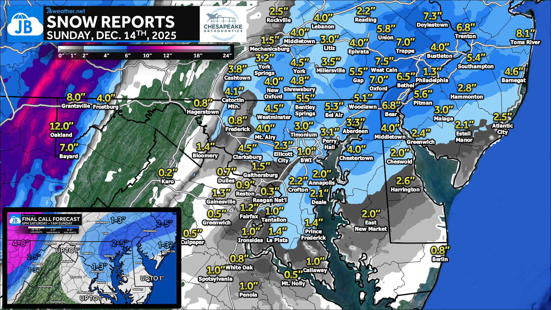
A narrow band of heavier snow developed northeast of I-95, producing widespread 4–6” totals across parts of southeast Pennsylvania, northeast Maryland, and northern New Jersey, with locally higher amounts reported in areas such as York, Lancaster, Harford, Baltimore, and Carroll counties. The mountains saw the highest totals overall, with 8–12” common across Garrett County and western Maryland, where colder air and stronger forcing persisted longer.
Farther south and southwest, totals dropped off quickly as expected. Areas south of US-50 and closer to the Potomac generally picked up under 1–2 inches, with some locations seeing less due to initially warmer temperatures and drier air limiting snowfall. This verified concerns for dry air intrusion and explains the tight snowfall gradient seen on the final map, resulting in minor impacts for most and localized moderate impacts where the heavier band set up.
Overall, the forecast performed well, correctly identifying the narrow corridor of higher snow totals northeast of I-95, the lighter amounts to the south due to dry air and marginal temperatures, and significantly higher snowfall in the mountains. The biggest takeaway from this event was the sharp snowfall gradient, with totals changing rapidly over short distances — a known challenge with fast-moving coastal systems.
NWS SNOW REPORTS
MARYLAND

...Allegany County...
  Frostburg               4.0   700 AM 12/14  Co-Op Observer
  Mount Savage            4.0   845 AM 12/14  Dept of Highways
  Frostburg  NW           4.0   840 AM 12/14  Dept of Highways
  Potomac Park 2 NW       2.0   839 AM 12/14  Dept of Highways
  Wolfe Mill 2 NNE        1.5   853 AM 12/14  Trained Spotter
  Cumberland  NW          1.0   840 AM 12/14  Dept of Highways
  Ridgeley 1 NW           0.8   925 PM 12/13  Trained Spotter

...Anne Arundel County...
  Odenton                 2.3   821 AM 12/14  Public
  Crofton 2 NNE           2.2   913 AM 12/14  NWS Employee
  Deale 1 ENE             2.1   954 AM 12/14  Trained Spotter
  Annapolis 1 S           2.0   823 AM 12/14  Trained Spotter
  Annapolis 1 SE          1.8   650 AM 12/14  Trained Spotter
  Chelsea Beach           1.5   736 AM 12/14  Trained Spotter
  Crofton 1 SSE           1.0   400 AM 12/14  NWS Employee
  Bwi Airport             1.0   700 AM 12/14  Official NWS Obs
  Baltmore-Washington     0.5   538 AM 12/14  Dept of Highways
  Parole                  0.5   537 AM 12/14  Dept of Highways

...Baltimore County...
  Bentley Springs 1 E     5.5   800 AM 12/14  Trained Spotter
  Long Green 2 NW         4.5   745 AM 12/14  Trained Spotter
  Glyndon 1 WSW           4.4   757 AM 12/14  Trained Spotter
  Bentley Springs 6 S     4.0   531 AM 12/14  Dept of Highways
  Cockeysville 2 NNW      3.5   807 AM 12/14  Broadcast Media
  Reisterstown 1 NE       3.5   947 AM 12/14  Trained Spotter
  Woodstock 1 ENE         3.3   447 AM 12/14  Trained Spotter
  Gunpowder 2 W           3.1  1009 AM 12/14  Trained Spotter
  Timonium 1 W            3.0   814 AM 12/14  Trained Spotter
  Kingsville 1 E          2.9   724 AM 12/14  Trained Spotter
  Rosedale 1 E            2.5   534 AM 12/14  Dept of Highways
  Arbutus                 2.3   829 AM 12/14  Trained Spotter
  Edgemere                2.3   956 AM 12/14  Trained Spotter
  Owings Mills            1.8   535 AM 12/14  Dept of Highways
  Pikesville              1.0  1220 AM 12/14  Trained Spotter
  Cockeysville            0.5  1217 AM 12/14  Broadcast Media
  Catonsville             0.5   159 AM 12/14  Social Media

...Baltimore City...
  Pimlico  SE             2.3   615 AM 12/14  Trained Spotter

...Calvert County...
  Prince Frederick 1 S    1.4   937 AM 12/14  Trained Spotter
  Chesapeake Beach        1.0   933 AM 12/14  Trained Spotter

...Carroll County...
  Gamber 1 WNW            5.5   837 AM 12/14  CoCoRaHS
  Watersville 1 N         5.1   727 AM 12/14  Trained Spotter
  Eldersburg 1 ESE        5.0   800 AM 12/14  Trained Spotter
  Millers 4 NE            4.6   800 AM 12/14  Co-Op Observer
  Winfield 1 N            4.5   730 AM 12/14  Trained Spotter
  Westminster 6 NE        4.5   618 AM 12/14  Social Media
  Sykesville              4.0   800 AM 12/14  Trained Spotter
  Uniontown 3 N           3.1   635 AM 12/14  Trained Spotter
  Westminster 1 NNE       3.0   533 AM 12/14  Dept of Highways

...Cecil County...
  Rock Springs 1 ESE      5.5   820 AM 12/14  Trained Spotter
  Woodlawn 2 ENE          5.1   950 AM 12/14  Trained Spotter
  Elkton 2 W              2.5   534 AM 12/14  Dept of Highways

...Charles County...
  La Plata 3 ENE          1.4   800 AM 12/14  Trained Spotter
  Ironsides 2 E           1.0   726 AM 12/14  Trained Spotter

...Frederick County...
  Sabillasville 2 SSE     4.1  1023 AM 12/14  Trained Spotter
  Mount Airy 1 SW         4.0   730 AM 12/14  Trained Spotter
  Green Valley 1 WNW      3.0   823 AM 12/14  Public
  Myersville              2.3   940 AM 12/14  Trained Spotter
  New Market              2.3   729 AM 12/14  Trained Spotter
  Ballenger Creek 1 E     2.0   533 AM 12/14  Dept of Highways
  Ballenger Creek         2.0  1018 AM 12/14  Trained Spotter
  Ballenger Creek 1 NW    1.6   938 AM 12/14  Trained Spotter
  Buckeystown 3 SW        1.4   700 AM 12/14  Trained Spotter
  Frederick 1 SE          0.8   955 AM 12/14  Trained Spotter
  New Market 1 ENE        0.8  1255 AM 12/14  Trained Spotter

...Garrett County...
  Oakland 4 WSW          12.0   920 AM 12/14  Emergency Mngr
  Loch Lynn Heights 2    12.0   918 AM 12/14  Emergency Mngr
  Accident 4 E           11.5   852 AM 12/14  Trained Spotter
  Oakland 4 SW           10.0   908 AM 12/14  Law Enforcement
  Mc Henry 7 W           10.0   858 AM 12/14  Dept of Highways
  Accident 5 ESE         10.0   900 AM 12/14  Dept of Highways
  Friendsville           10.0   925 AM 12/14  Emergency Mngr
  Mountain Lake Park 1   10.0   909 AM 12/14  Dept of Highways
  Oakland 4 NW           10.0   922 AM 12/14  Emergency Mngr
  Oakland 4 W            10.0   902 AM 12/14  Dept of Highways
  Oakland                10.0   921 AM 12/14  Emergency Mngr
  Oakland 5 NW           10.0   941 AM 12/14  Trained Spotter
  Deer Park 5 ENE         9.0   909 AM 12/14  Dept of Highways
  Grantsville             8.0   923 AM 12/14  Emergency Mngr
  McHenry                 8.0   800 AM 12/14  Emergency Mngr
  Grantsville 5 W         8.0   527 AM 12/14  Dept of Highways
  Mount Savage 4 WNW      8.0   926 AM 12/14  Dept of Highways
  Accident 3 NNE          8.0   858 AM 12/14  Dept of Highways
  Grantsville 7 WNW       7.0   726 AM 12/14  Trained Spotter
  Mc Henry 4 SE           7.0   850 AM 12/14  Park/Forest Srvc
  Accident 6 ESE          7.0   705 AM 12/14  Fire Dept/Rescue
  Barton                  5.0   848 AM 12/14  Public
  Friendsville 3 W        4.0   950 PM 12/13  Dept of Highways
  Mc Henry                3.0   944 PM 12/13  Trained Spotter

...Harford County...
  Chrome Hill 2 SE        6.0   940 AM 12/14  Trained Spotter
  Bel Air 2 NE            5.3   747 AM 12/14  Broadcast Media
  Fallston 3 N            4.7   721 AM 12/14  Trained Spotter
  Aberdeen Proving Gro    3.3   900 AM 12/14  Trained Spotter
  Churchville 1 SE        2.5   534 AM 12/14  Dept of Highways

...Howard County...
  Gaither 2 SE            4.6   720 AM 12/14  Trained Spotter
  Marriottsville 2 SSW    4.5   800 AM 12/14  NWS Employee
  West Friendship 2 NW    3.8   753 AM 12/14  Trained Spotter
  Simpsonville            3.0   957 AM 12/14  Trained Spotter
  Dayton 1 NE             2.5   532 AM 12/14  Dept of Highways
  Historic Ellicott Ci    2.3   825 AM 12/14  Trained Spotter
  Elkridge 2 W            2.0   721 AM 12/14  Trained Spotter
  Elkridge                1.7   822 AM 12/14  NWS Employee
  Simpsonville 1 SSE      1.6   810 AM 12/14  Trained Spotter

...Montgomery County...
  Damascus 3 SSW          4.8   704 AM 12/14  Co-Op Observer
  Damascus 1 S            4.5   723 AM 12/14  Trained Spotter
  Clarksburg 2 NW         4.5   917 AM 12/14  Emergency Mngr
  Damascus 1 SE           4.1   959 AM 12/14  Trained Spotter
  Brookeville 2 NW        1.8   942 AM 12/14  Trained Spotter
  Gaithersburg            1.5   535 AM 12/14  Dept of Highways
  Gaithersburg 2 E        1.5   639 AM 12/14  NWS Employee
  Germantown              1.4   933 AM 12/14  NWS Employee
  Norbeck 1 ESE           1.1   700 AM 12/14  Trained Spotter
  Leesburg 4 NE           1.0   943 AM 12/14  Trained Spotter
  Poolesville             0.7   805 AM 12/14  Emergency Mngr
  Aspen Hill 1 SW         0.7   938 AM 12/14  Trained Spotter
  Potomac                 0.7   806 AM 12/14  Emergency Mngr
  Somerset 1 ENE          0.6  1012 AM 12/14  Trained Spotter

...St. Marys County...
  Callaway 2 W            1.0   731 AM 12/14  Trained Spotter
  California 3 W          0.8   831 AM 12/14  Trained Spotter
  Ridge 1 E               0.8   942 AM 12/14  Trained Spotter

...Washington County...
  Sabillasville 2 NNW     4.3   713 AM 12/14  CoCoRaHS
  Boonsboro 3 NNE         1.9   615 AM 12/14  Trained Spotter
  Boonsboro 1 SSE         1.5   936 AM 12/14  Trained Spotter
  Funkstown 2 WSW         1.3   536 AM 12/14  Dept of Highways
  Hagerstown              0.4   700 AM 12/14  Co-Op Observer
  Pecktonville 3 NNW        T   735 AM 12/14  NWS Employee

Pennsylvania

...Adams County...
New Oxford 0.8 SE            4.0 in    0800 AM 12/14   COCORAHS
York Springs 2.5 N           3.2 in    0700 AM 12/14   COCORAHS
Abbottstown 2.4 N            2.0 in    0700 AM 12/14   COCORAHS

...Cumberland County...
Mechanicsburg 1.0 NNW        1.5 in    0652 AM 12/14   COCORAHS
Carlisle                     1.0 in    0700 AM 12/14   COOP
Carlisle 3.3 WSW             1.0 in    0700 AM 12/14   COCORAHS

...Dauphin County...
Middletown 2.9 NW            5.1 in    0800 AM 12/14   COCORAHS
Middletown 3.5 E             5.1 in    0800 AM 12/14   COCORAHS
Hershey 2.1 NW               3.5 in    0700 AM 12/14   COCORAHS
Harrisburg 6.0 NE            2.3 in    0700 AM 12/14   COCORAHS

...Lancaster County...
Gap 0.3 NW                   5.5 in    0700 AM 12/14   COCORAHS
Ephrata 0.9 E                4.0 in    0730 AM 12/14   COCORAHS
Elizabethtown 1.1 N          4.0 in    0800 AM 12/14   COCORAHS
New Holland 0.4 WNW          4.0 in    0750 AM 12/14   COCORAHS
Landisville 0.8 WSW          4.0 in    0726 AM 12/14   COCORAHS
Lititz 0.3 WNW               3.0 in    0800 AM 12/14   COCORAHS
Landisville 1.2 ESE          2.2 in    0730 AM 12/14   COCORAHS
2.1 SE New Holland           1.5 in    1200 AM 12/14   COOP

...Lebanon County...
Lebanon 1.3 SW               4.0 in    0700 AM 12/14   COCORAHS
Palmyra 2.1 S                3.5 in    0700 AM 12/14   COCORAHS
Lebanon 4.8 N                3.1 in    0700 AM 12/14   COCORAHS

...York County...
York Haven 2.3 WNW           5.2 in    0800 AM 12/14   COCORAHS
Stewartstown 0.5 S           5.0 in    0733 AM 12/14   COCORAHS
Mount Wolf 1.0 SE            4.5 in    0800 AM 12/14   COCORAHS
York 3.4 NE                  4.5 in    0800 AM 12/14   COCORAHS
Valley Green 0.8 ENE         4.3 in    0700 AM 12/14   COCORAHS
East Berlin 3.4 ESE          3.7 in    0600 AM 12/14   COCORAHS

VIRGINIA

...Albemarle County...
  Glendower 2 NE          0.1   717 AM 12/14  Trained Spotter

...Arlington County...
  Reagan National Apt     0.3   652 AM 12/14  Official NWS Obs

...City of Alexandria...
  Alexandria 1 W          1.0   830 AM 12/14  Trained Spotter

...Culpeper County...
  Culpeper 1 W            0.4   800 AM 12/14  Trained Spotter

...Fairfax County...
  Fairfax Station 1 SE    1.2   956 AM 12/14  Trained Spotter
  Tantallon 2 W           1.0   725 AM 12/14  Trained Spotter
  Vienna                  1.0   730 AM 12/14  Co-Op Observer
  Reston 2 N              0.9   716 AM 12/14  NWS Employee
  Chantilly 2 ENE         0.8   729 AM 12/14  Trained Spotter
  Herndon 1 NNE           0.8   722 AM 12/14  Trained Spotter
  Reston 2 SSW            0.7   732 AM 12/14  NWS Employee

...Fauquier County...
  Greenwich 1 W           0.5   952 AM 12/14  Other Federal

...Frederick County...
  Winchester 3 E          0.5   606 AM 12/14  Trained Spotter

...Highland County...
  Mill Gap 1 SW           0.1   700 AM 12/14  Co-Op Observer

...Loudoun County...
  Bloomery 3 ESE          1.9   630 AM 12/14  Trained Spotter
  Lucketts  W             1.8  1020 AM 12/14  NWS Employee
  Ashburn                 1.0   954 AM 12/14  Trained Spotter
  Ashburn 1 W             1.0   800 AM 12/14  NWS Employee
  Leesburg 1 E            1.0   700 AM 12/14  NWS Employee
  Purcellville            0.8   700 AM 12/14  Co-Op Observer
  Dulles International    0.7   700 AM 12/14  Official NWS Obs
  Leesburg 2 WNW          0.1  1200 AM 12/14  NWS Employee

...Page County...
  Stanley 2 WSW           0.3   745 AM 12/14  Trained Spotter

...Prince William County...
  Gainesville 1 WNW       1.3   949 AM 12/14  Trained Spotter
  Woolsey 1 SW            0.3  1008 AM 12/14  Trained Spotter

...Rockingham County...
  Elkton                  0.5   521 AM 12/14  Social Media

...Spotsylvania County...
  Spotsylvania Court 1    1.0   959 AM 12/14  Trained Spotter
  Dunavant 1 S            1.0   953 AM 12/14  Trained Spotter
  White Oak 4 SSW         0.8   856 AM 12/14  Trained Spotter

...Stafford County...
  Holly Corner 2 E        0.8   756 AM 12/14  Trained Spotter

...Warren County...
  Linden 3 W              1.0   748 AM 12/14  Trained Spotter
  Karo 1 WSW              0.2   800 AM 12/14  Trained Spotter

WEST VIRGINIA

...Berkeley County...
  Martinsburg 2 E         0.8   845 AM 12/14  NWS Employee
  Falling Waters 2 NW     0.3   714 AM 12/14  Trained Spotter

...Grant County...
  Bayard                  7.0   930 AM 12/14  Co-Op Observer

...Jefferson County...
  Millville 1 ESE         1.5   826 AM 12/14  Trained Spotter
  Bloomery 3 SSE          1.4   630 AM 12/14  Trained Spotter

...Pendleton County...
  Seneca Rocks            1.0   939 AM 12/14  Public
  Franklin                  T   948 AM 12/14  Dept of Highways
John Bordash
View More PostsJB Weather forecaster John Bordash is working around the clock to provide Southern Maryland, and neighboring communities, with accurate and reliable weather information.
2 thoughts on “Snowfall Totals In: Heaviest Band Sets Up Northeast of I-95”
Comments are closed.
Great information 👍
Alot of information letting us know how much snow ❄️ in Eastern Shore Maryland, west Virginia, Maryland.
Thank you