Brought to you by Sonder Studios
Not much has changed with our Friday winter weather forecast, as a weak system continues to show a classic cold air damming setup across the Mid-Atlantic. While this will not be a major winter storm, light wintry precipitation remains likely, especially north of Baltimore, during the afternoon and evening hours.
A weak storm system will track east through the Ohio River Valley on Friday and run into a strong area of high pressure anchored over southern Canada. This high pressure will funnel cold air southward at the surface, trapping it near the ground while warmer air moves in aloft, a setup known as cold air damming (CAD). As precipitation overspreads the region, it will fall into this shallow cold layer, allowing wintry precipitation to develop despite relatively mild air above.
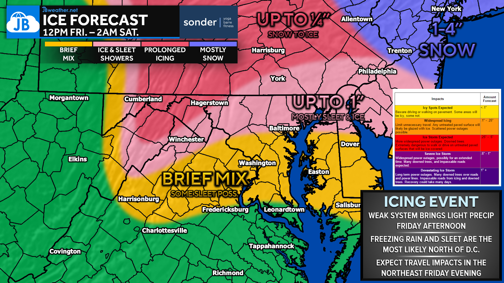
Precipitation is expected to begin after noon Friday, initially as scattered sleet and freezing rain showers. Across much of Pennsylvania, a brief period of snow is possible at the onset, though accumulations should remain under 1 inch. As the afternoon progresses, sleet and freezing rain become more widespread north of Baltimore, where precipitation will be more consistent and longer-lasting. Higher ice totals are expected in central and northern Pennsylvania, while amounts decrease farther south toward the D.C. metro due to more intermittent precipitation.
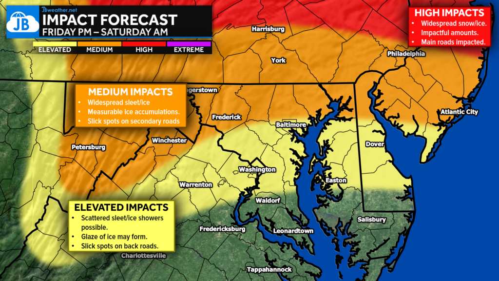
The greatest impacts are expected in inland areas north of I-95, where measurable ice accumulations could lead to slick roads and hazardous travel conditions. Secondary roads are most likely to be affected, though untreated surfaces could become slippery quickly. Farther south, including parts of southern Maryland, precipitation will be more scattered, but brief snow or sleet showers are still possible. While totals remain light overall, the timing Friday afternoon and evening means travel disruptions are still a concern, particularly for areas farther north.
❓ Storm FAQs
When does precipitation start?
Light precipitation is expected to begin after noon on Friday, becoming more widespread through the afternoon and evening.
Who is most likely to see impacts?
Areas north of Baltimore, especially into Pennsylvania and inland locations, will see the most consistent wintry precipitation and higher ice potential.
What types of precipitation are expected?
This will be a wintry mix — starting as snow in parts of PA, then changing to sleet and freezing rain, and eventually tapering off or changing to rain farther south.
How much snow or ice are we expecting?
Snow amounts should stay under 1 inch, but ice accumulation is possible, especially in PA where precipitation lasts longer.
Will this impact travel?
Yes. Slick spots are likely, especially on secondary and untreated roads, mainly Friday afternoon and evening north of I-95.
Is this a major winter storm?
No, this is a low-end but impactful icing setup, typical of cold air damming events, with the highest impacts focused inland and farther north.
Stay with JB Weather for the latest information on impacts here in Southern Maryland and across the Mid-Atlantic. You can always access my forecasts and updates here on the website, on Facebook, on Twitter, on Instagram, and on YouTube. JB Weather is the Mid-Atlantic’s Weather Leader, and I am working around the clock to keep you ahead of any storm!

SONDER STUDIOS® is home to Yoga, Pilates, Barre, and Strength classes in Calvert County. Wellness is our business, and belonging is at the heart of our culture. We are grateful for your trust for 6+ years. Sign up for an intro week at www.sonderstudios.us
John Bordash
View More PostsJB Weather forecaster John Bordash is working around the clock to provide Southern Maryland, and neighboring communities, with accurate and reliable weather information.