Brought to you by Row House (SOMD)
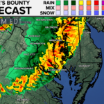
The Storm Prediction Center in Norman, OK has issued a SEVERE THUNDERSTORM WATCH for our entire region. This watch is in effect until 11PM Saturday.
Primary threats this evening are:
- Scattered damaging wind gusts to 70 mph lieky
- Torrential rains leading to flash flooding
- An isolated weak tornado or two
SUMMARY: Storms will continue to develop and intensify within the destabilizing warm sector across a portion of the Middle Atlantic and the Northeast States this afternoon and evening. Mostly multicells and some marginal supercell structures are expected with storms evolving into lines and bowing segments capable of mainly scattered wind damage.
PRECAUTIONARY/PREPAREDNESS ACTIONS: A Severe Thunderstorm WATCH means conditions are favorable for severe thunderstorms in and close to the watch area. Persons in these areas should be on the lookout for threatening weather conditions and listen for later statements and possible warnings. Severe thunderstorms can and occasionally do produce tornadoes.
It will be important to stay with JB Weather for the latest information on impacts here in Southern Maryland. You can always access my forecasts and updates here on the website, on Facebook, on Twitter, and on YouTube. JB Weather is Southern Maryland’s Weather Leader, and I am working around the clock to keep you ahead of the storm!
-JB

Row House SOMD is more than just a workout; it’s about people, connection, strength and community. Our classes offer varied programming, helping you progress your workout and avoid plateaus. In our boat there’s a seat for everyone, so contact us TODAY at 301.686.7788 and mention JB Weather to schedule a FREE introductory class. Also receive a FREE GIFT when you sign up for a membership.
1 thought on “Severe Thunderstorm Watch Issued Until 11PM”
Comments are closed.


I’m a new fan and follower of your forecasting.