Brought to you by Cedar Point Federal Credit Union
A major winter storm is set to impact the Mid-Atlantic this weekend, bringing a long duration of snow, sleet, and ice with significant travel impacts expected from Saturday night through Monday morning. Confidence is increasing in a widespread event, with the highest impacts focused on Sunday as heavy precipitation overspreads the region.
The Setup: Coastal Transfer Drives the Storm
This storm begins as a strong area of low pressure tracking north before transferring its energy to the coast, a classic setup for high-impact winter weather in the Mid-Atlantic. As shown in the European model graphic, cold air remains firmly in place to the north while warmer air is forced aloft from the south, creating a sharp temperature contrast across the region.
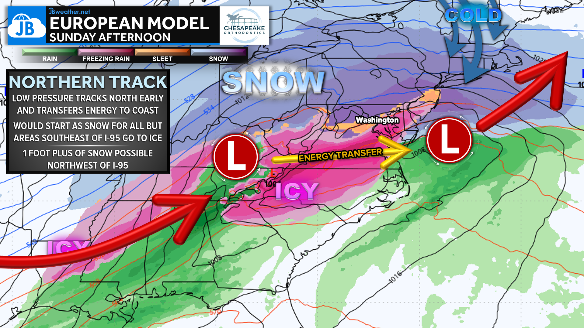
This setup supports heavy snow northwest of I-95, while areas along and southeast of the corridor are more susceptible to sleet and freezing rain as warmer air noses in above the surface. The exact placement of this transition zone will be critical in determining final snow and ice totals.
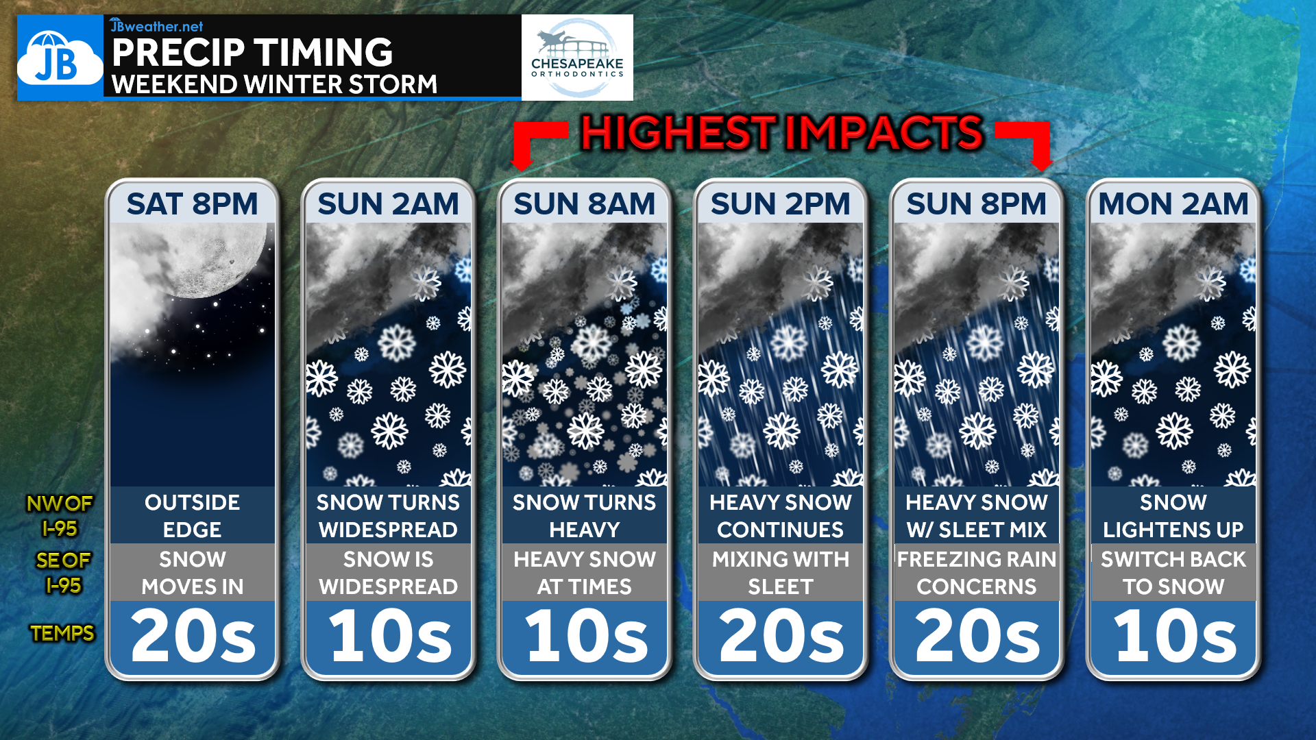
Timing: When Impacts Are Highest
Snow begins moving into the region after sunset Saturday, initially impacting areas northwest of I-95 before expanding southeast overnight. By early Sunday morning, snow becomes widespread and heavy at times, marking the start of the highest-impact portion of the storm.
Sunday afternoon into Sunday evening is when complications increase, as parts of the region transition from snow to sleet and freezing rain. Precipitation remains steady through Sunday night before gradually tapering off early Monday morning, with lighter snow lingering in colder areas.
Precipitation Types: Sharp Gradients Expected
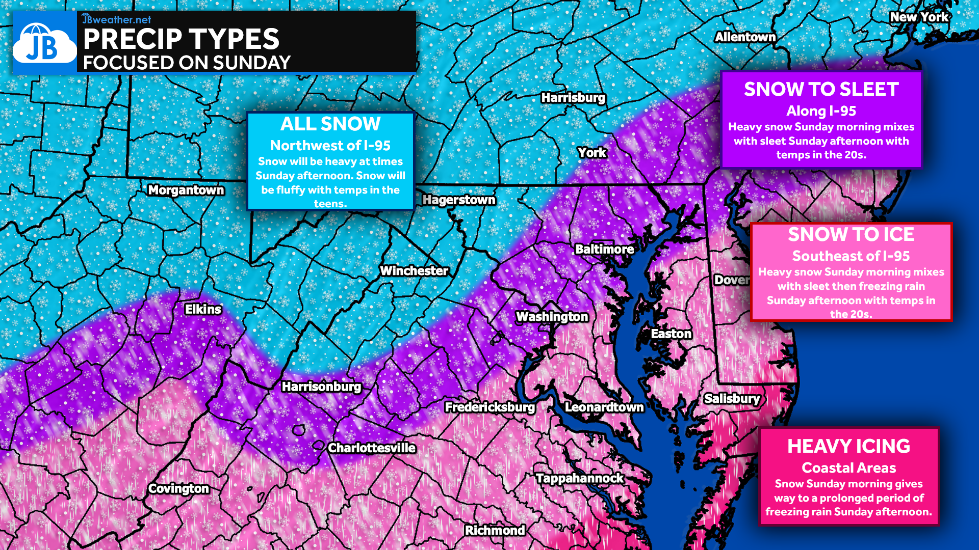
- Northwest of I-95: All snow for the duration of the storm. Snow will be heavy at times, especially Sunday morning and early afternoon, with colder temperatures supporting fluffier accumulations.
- Along I-95: Snow Sunday morning transitions to sleet later Sunday afternoon. This zone is the most sensitive to small track changes and could see notable shifts in totals.
- Southeast of I-95 & Coastal Areas: Heavy snow in the morning mixes with sleet by midday and then freezing rain Sunday afternoon, with prolonged icing possible into Sunday evening.
Snow Forecast: Widespread Accumulations
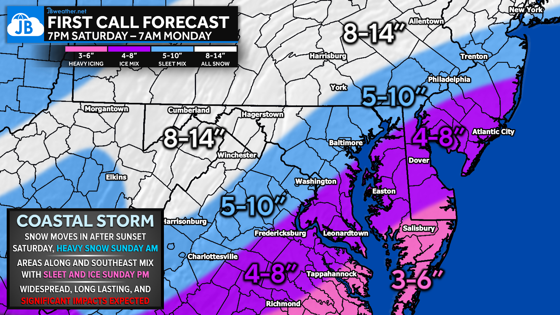
Snowfall will be widespread across the region, with the highest totals expected northwest of I-95, where colder air remains locked in for the duration of the storm. These areas can expect 8–14 inches of snow, with heavy rates at times Sunday morning and early afternoon. Along the I-95 corridor, snow totals of 5–10 inches are expected before mixing with sleet reduces additional accumulation. Farther southeast, snowfall amounts will generally range from 3–6 inches, as snow transitions to sleet and freezing rain more quickly.
Ice Forecast: Increasing Confidence in Impacts
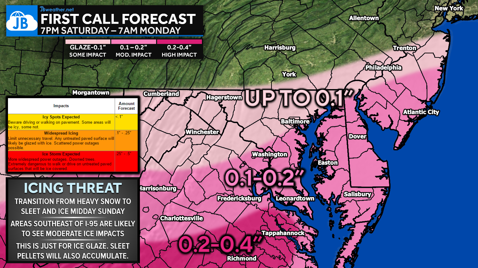
Icing becomes a growing concern Sunday afternoon as warmer air moves in aloft while surface temperatures remain below freezing. Areas along I-95 may see up to 0.1 inch of ice, which is enough to cause hazardous travel conditions. Southeast of I-95, ice accumulations increase to 0.1–0.2 inches, with 0.2–0.4 inches possible in southern and coastal areas, raising concerns for power outages and tree damage. These amounts represent ice glaze only, with additional impacts from sleet accumulation expected.
Bottom Line
This will be a long-duration, high-impact winter storm with dangerous conditions developing quickly and lasting through much of Sunday. Snow will become heavy overnight and continue into Sunday morning, followed by a transition to sleet and freezing rain from south to north Sunday afternoon. Travel conditions will deteriorate rapidly, especially during the Sunday morning through Sunday evening window when impacts are highest. With bitter cold temperatures, accumulating snow, and significant icing in parts of the region, this is a storm where preparation should be completed before snow begins Saturday night.
Stay with JB Weather for the latest information on impacts here in Southern Maryland. You can always access my forecasts and updates here on the website, on Facebook, on Twitter, on Instagram, and on YouTube. JB Weather is the Mid-Atlantic’s Weather Leader, and I am working around the clock to keep you ahead of any storm!
Cedar Point has been providing trusted banking, lending and personal finance solutions to the Southern Maryland Community since 1945. Visit the credit union at any of its 6 locations in St. Mary’s, Charles and Calvert counties or online at www.cpfcu.com.
John Bordash
View More PostsJB Weather forecaster John Bordash is working around the clock to provide Southern Maryland, and neighboring communities, with accurate and reliable weather information.
1 thought on “First Call Forecast: A Long-Lasting, High-Impact Winter Storm”
Comments are closed.
Thank you for all that you do resulting in serving so many.