Brought to you by Sonder Studios
Confidence continues to increase that a high-impact winter storm will affect the region from Saturday night through Monday morning, with multiple hazards including heavy snow, prolonged sleet, and dangerous ice. While snowfall totals will grab attention, this is not a “snow map only” storm — the transition to sleet and freezing rain will be just as impactful, if not more so, especially southeast of I-95. Travel conditions will deteriorate rapidly Sunday morning and remain hazardous well into Monday.
The Setup: What’s Driving This Storm
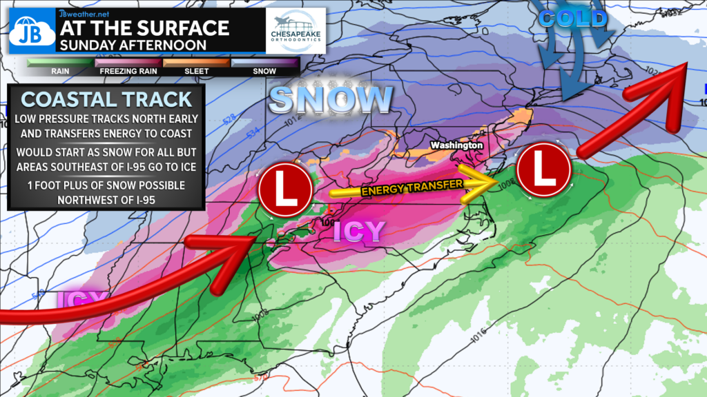
At the surface, low pressure initially tracks inland before transferring energy to a strengthening coastal low. Cold air remains locked in place across much of the region, while warmer air aloft surges northward, creating a classic overrunning setup. This allows precipitation to fall through multiple temperature layers, setting the stage for snow, sleet, and freezing rain to coexist — sometimes within just a few miles of each other.
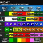
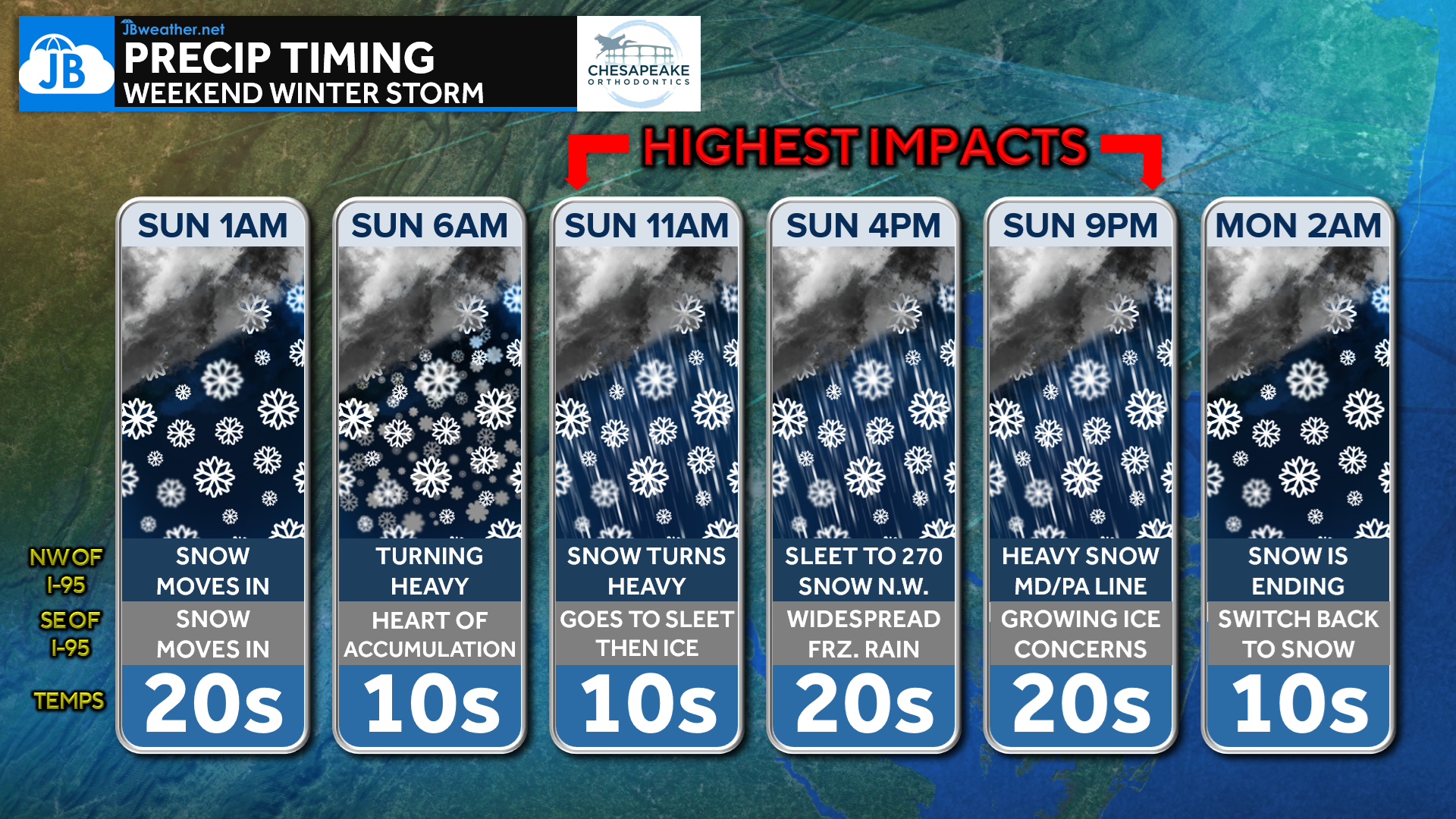
Timing & Evolution (Futurecast Overview)
Snow overspreads the region late Saturday night, becoming widespread by early Sunday morning. A heavy initial “thump” of snow develops before daybreak Sunday, especially northwest of I-95, where snowfall rates may exceed an inch per hour for a time. By late Sunday morning into early afternoon, warmer air aloft pushes northward, causing snow to transition to sleet from southeast to northwest. Freezing rain then becomes more widespread Sunday afternoon and evening, particularly closer to the coast and across southern Maryland and Virginia. As colder air filters back in late Sunday night into early Monday, precipitation gradually switches back to snow before tapering off.
Why Precipitation Type Matters
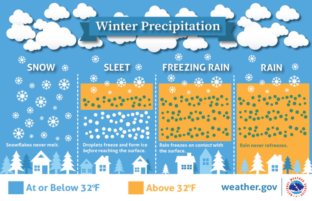
Not all winter precipitation behaves the same — and this storm highlights that perfectly. Snowflakes remain frozen from cloud to ground, while sleet forms when snow melts aloft and then refreezes before reaching the surface, creating ice pellets that accumulate efficiently. Freezing rain occurs when snow melts completely aloft and freezes on contact, coating roads, trees, and power lines in ice. Even with surface temperatures below 32°, sleet and freezing rain can dominate if warmer air exists just above the ground — which is exactly what we expect Sunday afternoon.
Overall Impact Summary
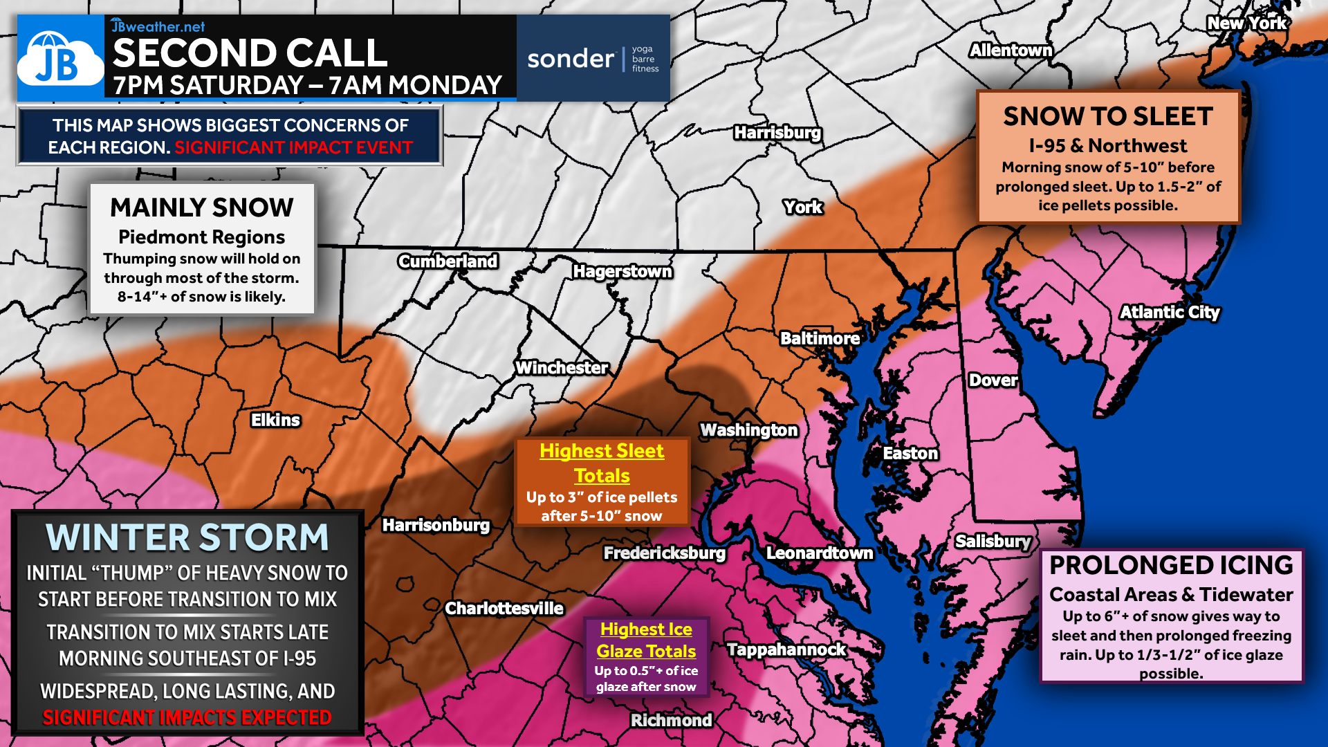
This storm brings different primary hazards to different regions, and no single map tells the full story. Northwestern areas will see the longest duration of snow, while locations closer to and southeast of I-95 face a prolonged period of sleet and freezing rain. Impacts will be widespread, long-lasting, and significant, with travel becoming extremely difficult — and in some areas, nearly impossible.
Snowfall Forecast
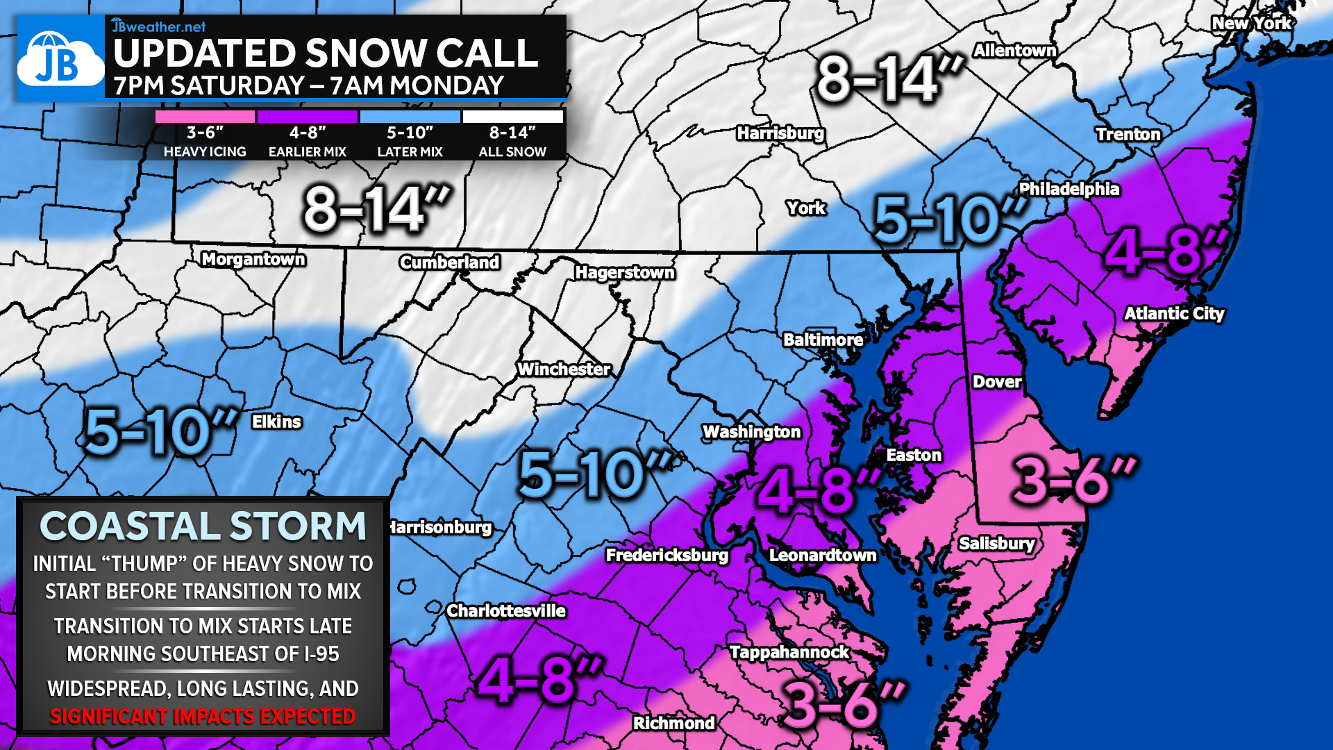
The highest snowfall totals are expected across the Piedmont and areas northwest of I-95, where colder air holds firm the longest. These locations are likely to see 8–14 inches of snow, with locally higher amounts possible where snow remains dominant for most of the event. Farther south and east, snowfall totals drop as earlier transitions to sleet and ice cut into accumulation, generally seeing 4-8 inches, much of which will fall early Sunday. 3-6 inches will be likely closer to the Atlantic beaches.
Sleet Forecast

The most impactful sleet accumulations are expected from parts of western Maryland through the central Shenandoah Valley and into interior Virginia. In these areas, snow transitions to sleet for several hours Sunday afternoon, leading to 1–3 inches of sleet accumulation on top of earlier snow. Sleet compacts efficiently, adding significant weight and making road conditions especially treacherous.
Ice Accretion Forecast
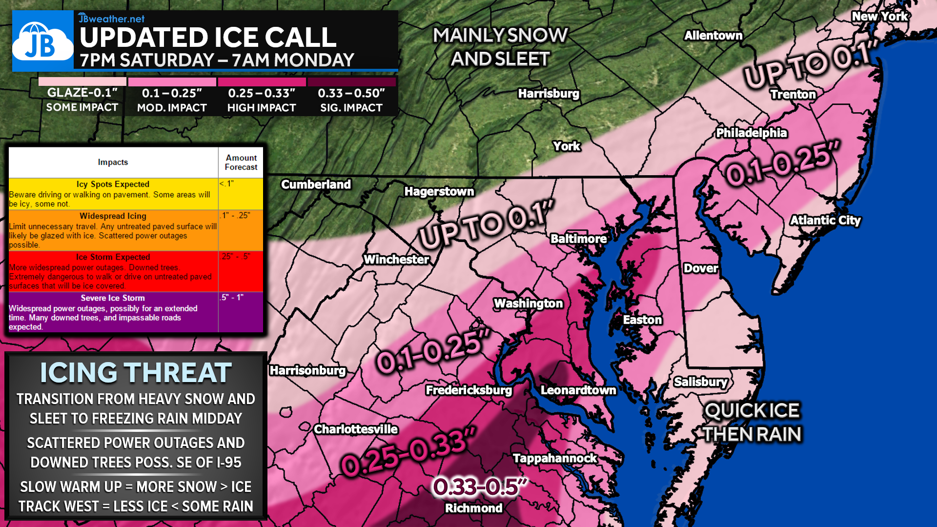
Freezing rain becomes the dominant concern southeast of I-95 Sunday afternoon through Sunday night. Coastal Maryland, southern Maryland, and eastern Virginia may see ¼ to ½ inch of ice accretion, enough to cause scattered power outages, downed trees, and impassable roads. Even small differences in temperature will determine how severe icing becomes, but confidence is high that damaging ice is a real threat in these areas.
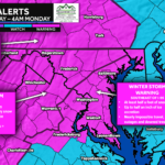
Winter Storm Warnings
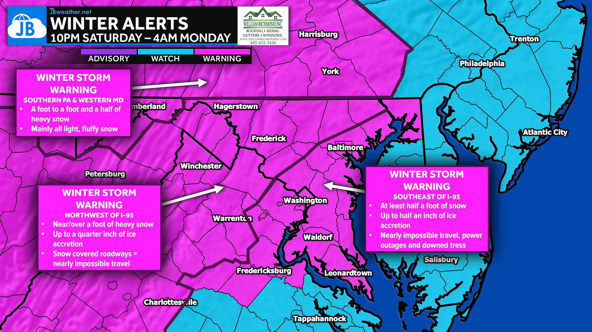
Winter Storm Warnings are in effect across much of the region, though for different reasons. Northwest of I-95, warnings are driven primarily by heavy snow totals. Southeast of I-95, warnings reflect the combined threat of snow, sleet, and significant ice accretion. Regardless of location, conditions meet warning criteria due to the severity and duration of impacts.
Ice Storm Impacts
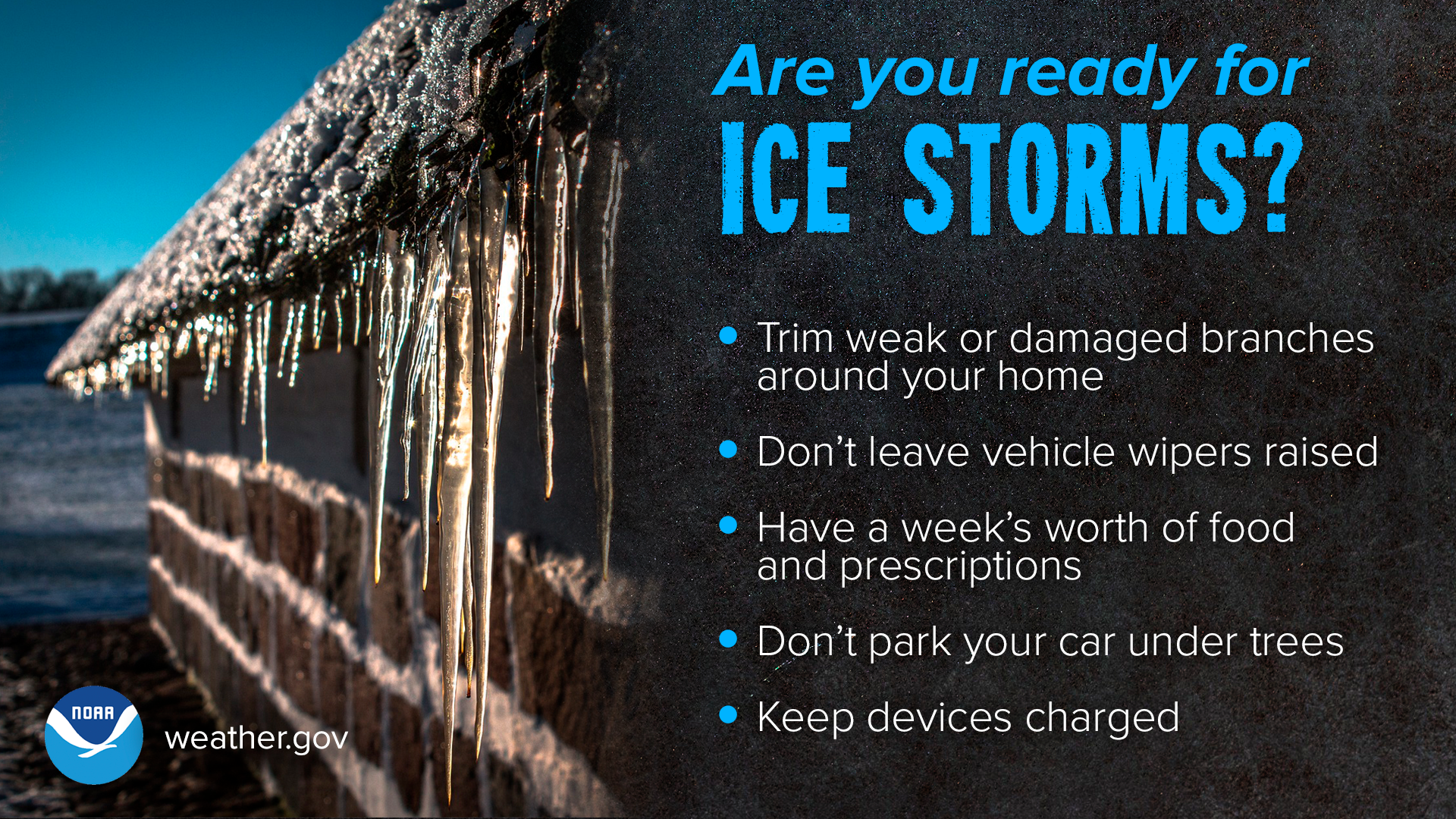
Ice is often the most dangerous winter hazard, and this storm has the potential to produce high-end ice impacts in parts of the region. Accreting ice on trees and power lines increases the risk of outages, while untreated roads will become extremely slick. Travel Sunday afternoon and evening is strongly discouraged, especially in areas expecting freezing rain.
Bottom Line
This is a long-duration, multi-hazard winter storm with impacts lasting well beyond the end of snowfall. Sunday will be the most dangerous travel day, with conditions worsening through the afternoon and evening as sleet and ice take over. Prepare now, plan to stay off the roads if possible, and expect lingering impacts into Monday morning even after precipitation ends.
Stay with JB Weather for the latest information on impacts here in Southern Maryland and across the Mid-Atlantic. You can always access my forecasts and updates here on the website, on Facebook, on Twitter, on Instagram, and on YouTube. JB Weather is the Mid-Atlantic’s Weather Leader, and I am working around the clock to keep you ahead of any storm!

SONDER STUDIOS® is home to Yoga, Pilates, Barre, and Strength classes in Calvert County. Wellness is our business, and belonging is at the heart of our culture. We are grateful for your trust for 6+ years. Sign up for an intro week at www.sonderstudios.us
John Bordash
View More PostsJB Weather forecaster John Bordash is working around the clock to provide Southern Maryland, and neighboring communities, with accurate and reliable weather information.