Brought to you by Bill Oosterink, Realtor
We’re entering the final hours before a high-impact winter storm affects much of the Mid-Atlantic. While the overall setup remains familiar, confidence has increased in the ice component of this storm, which raises concern for travel and power impacts, especially southeast of I-95. This is a significant winter event with multiple hazards unfolding over time.
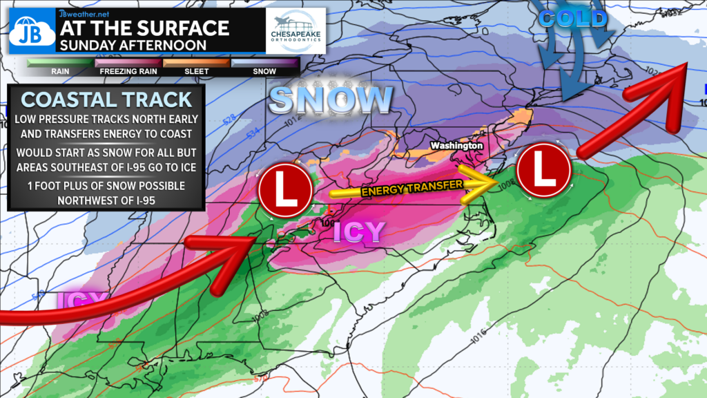
This storm develops as low pressure tracks north early, then transfers energy to the coast, allowing cold air to remain locked in across much of the region. That setup supports an initial thump of snow for nearly everyone before warmer air aloft works in, leading to a transition to sleet and freezing rain—especially from I-95 east and south. Northwest of I-95 stays colder longer, allowing snow to dominate.
Winter Storm Warnings
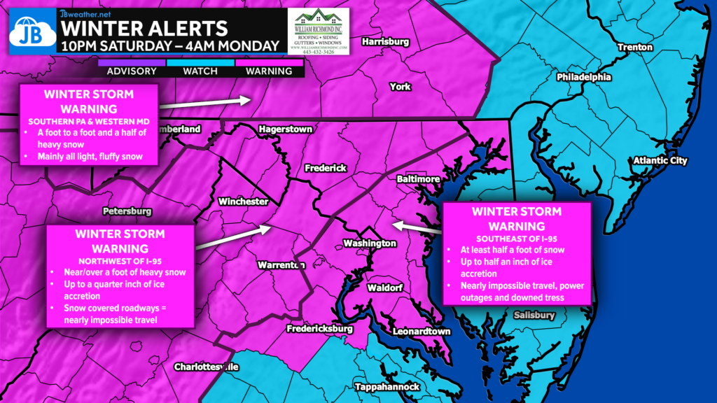
Winter Storm Warnings are up across much of the region, including areas northwest and southeast of I-95. Northwest zones face the threat of heavy, long-duration snowfall, while areas closer to the coast and Tidewater are dealing with a dangerous combination of snow, sleet, and ice accretion. Regardless of precipitation type, impacts will be significant and widespread.
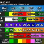
Timing & Evolution
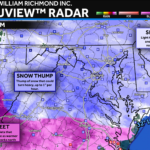
Futurview will show the how of this storm, while the timing graphic shows the when. In the Futurview video, you’ll see snow overspread the region late tonight into early Sunday, with a widespread morning “thump” of heavy snow before warmer air aloft pushes north and forces a transition to sleet and freezing rain from southeast to northwest.
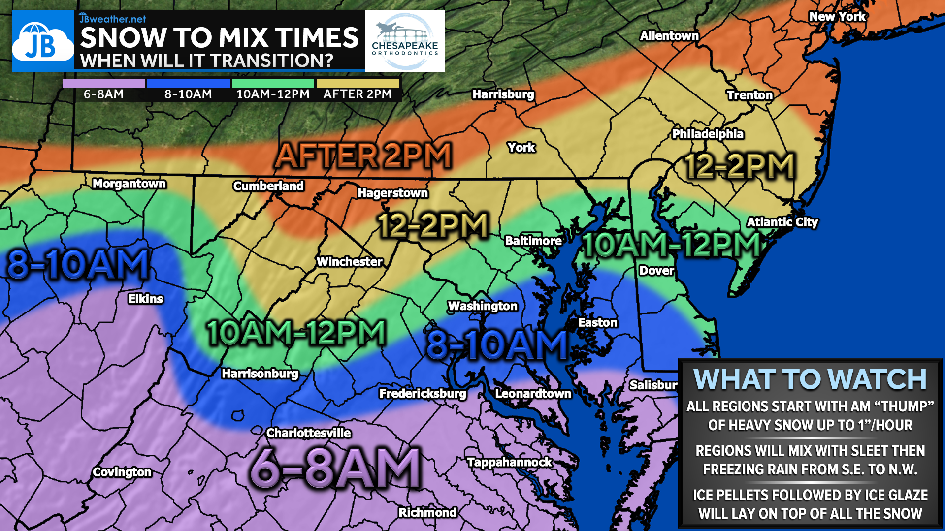
This Snow-to-Mix Timing graphic then breaks that evolution down by location, highlighting when snow is most likely to change to a mix in your area. This will be earlier in southern and coastal zones, later along and northwest of I-95, and latest in the higher terrain. Together, these graphics tell the full story: heavy snow first for everyone, followed by a gradual and uneven transition to sleet and ice as the day goes on.
Overall Final Call
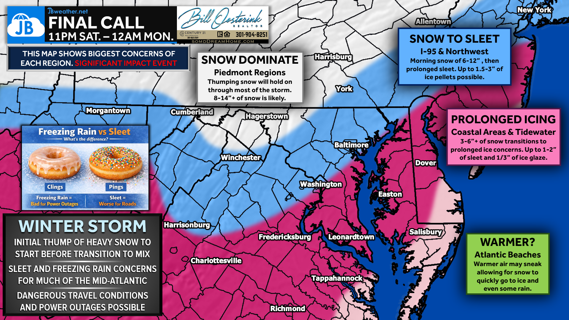
This forecast is not a wholesale change from prior updates, but refinements have been made as the ice threat has come into clearer focus. Confidence has increased that sleet and freezing rain will play a more meaningful role southeast of I-95, increasing the risk for power outages and prolonged travel issues. Snow totals remain largely consistent with previous calls.
Overall Snow
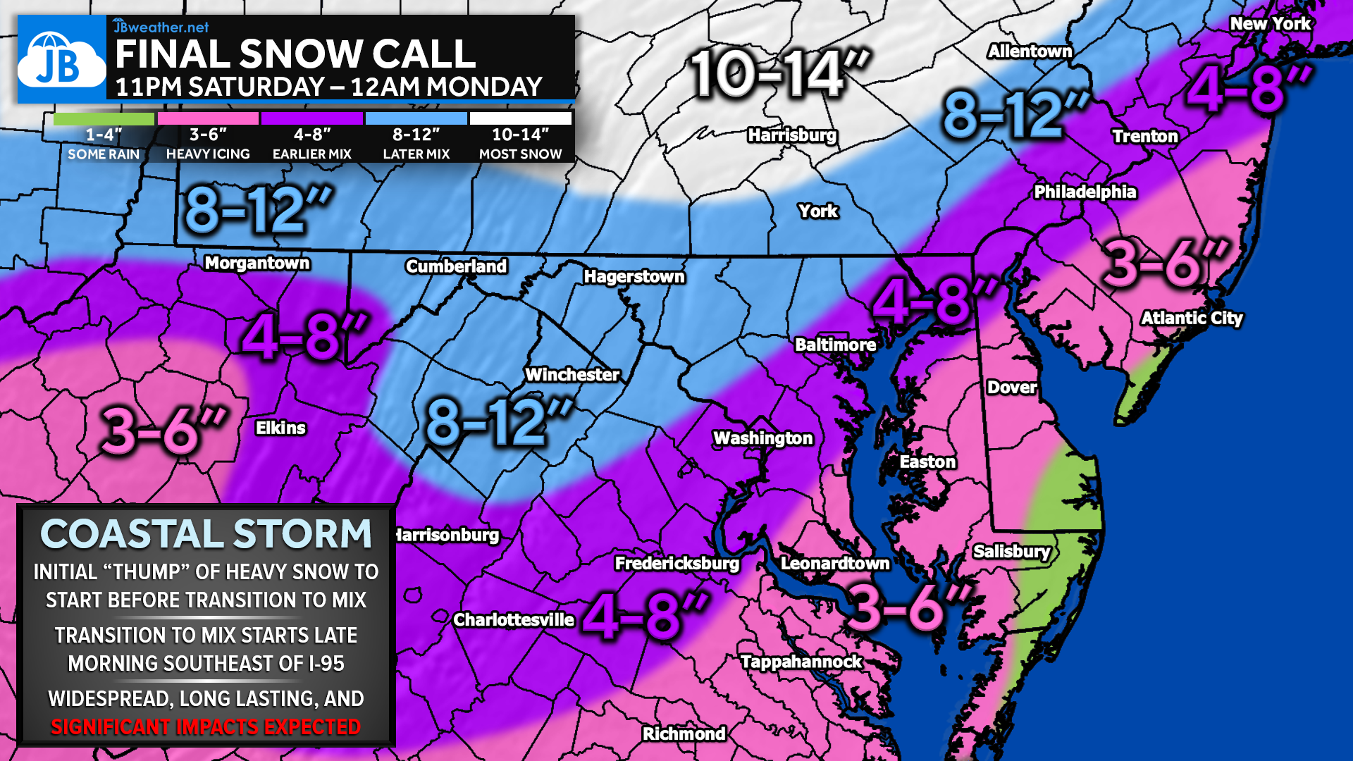
The heaviest snow is expected northwest of I-95, where cold air holds strongest and longest. These areas are likely to see widespread 8–14 inches, with locally higher totals in the higher terrain. Along and just east of I-95, snow still comes down hard initially, but totals are reduced as sleet and ice cut into overall accumulation.
Overall Sleet
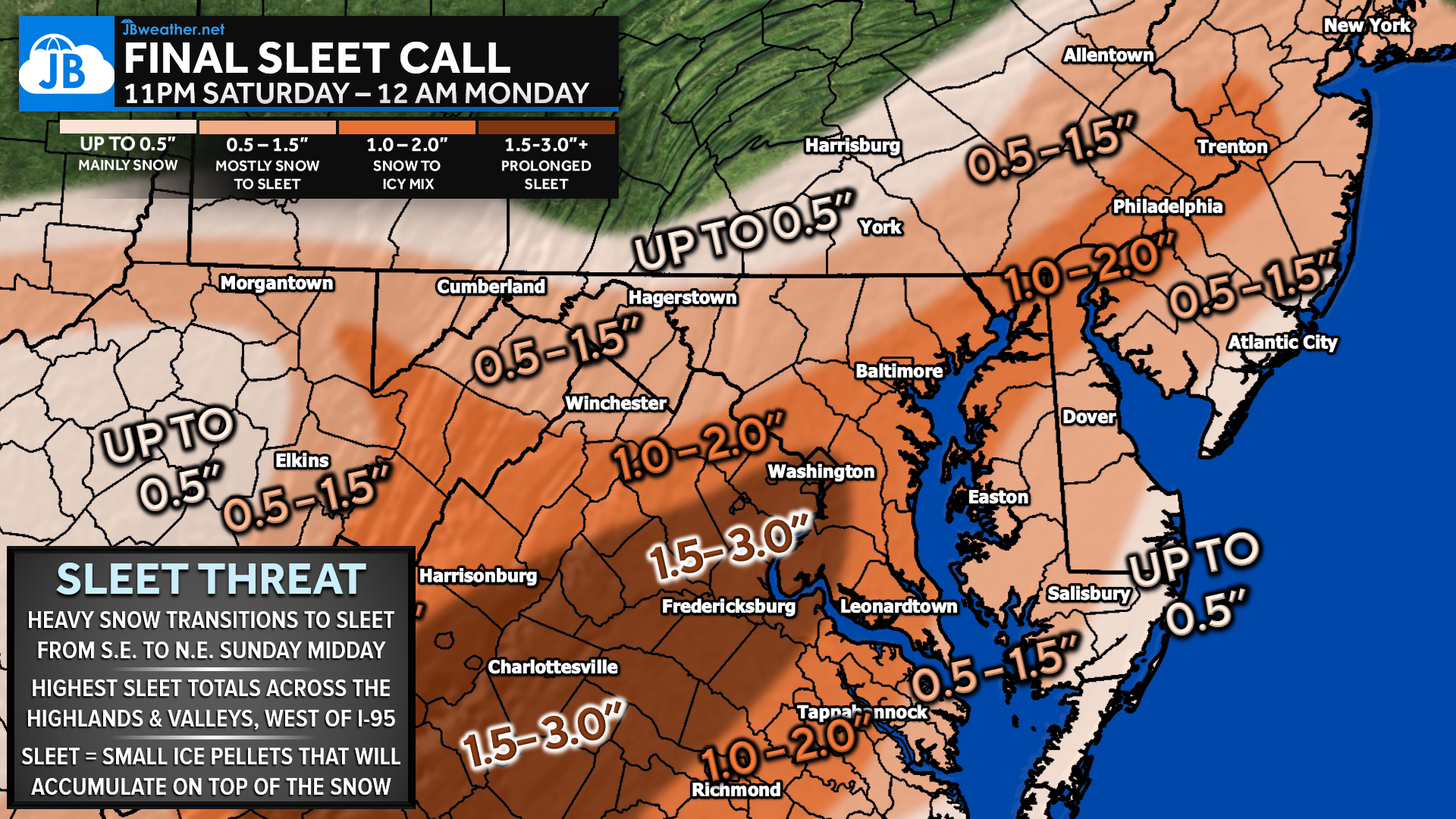
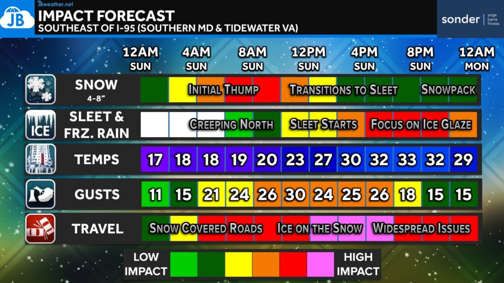
Sleet becomes a major player from late morning through Sunday afternoon, especially along and southeast of I-95. In these areas, sleet accumulation of 1 to 3 inches is possible, which will compact the snowpack and significantly worsen road conditions. Farther west, sleet amounts decrease as colder surface temperatures favor snow.
Overall Ice (Freezing Rain)
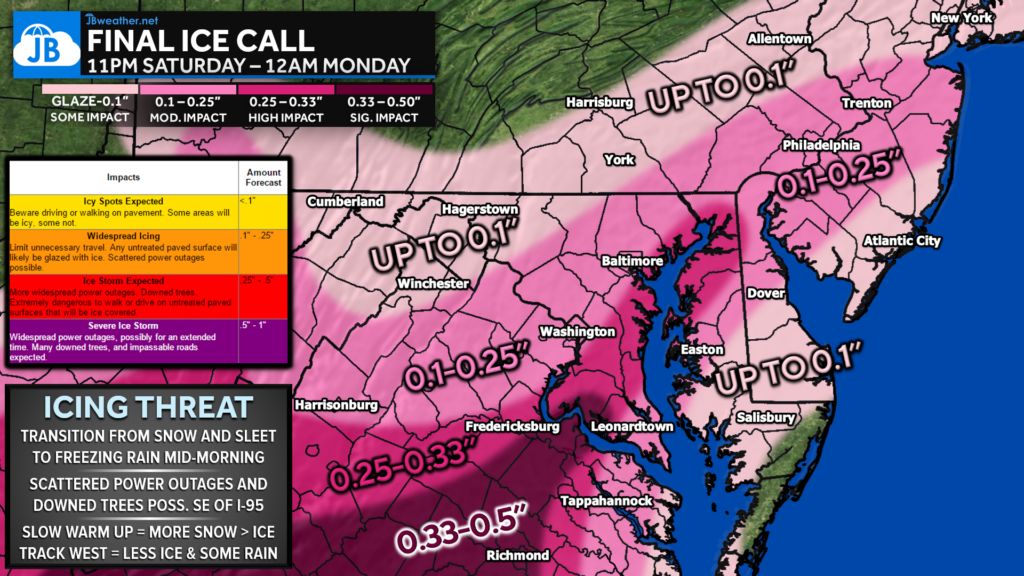
The greatest icing threat exists across southern Maryland, the Lower Eastern Shore, and Tidewater Virginia, where a longer period of freezing rain is possible. Ice accretion of one-quarter inch or more could lead to scattered power outages and tree damage. Farther north and west, icing amounts are lighter but still capable of creating hazardous conditions.
Sleet vs. Freezing Rain: Why It Matters
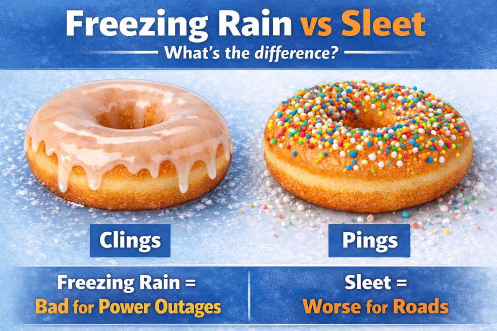
Sleet and freezing rain behave very differently. Sleet “pings” off surfaces and piles up, making roads extremely slick but limiting damage to trees and power lines. Freezing rain, on the other hand, clings to surfaces—coating roads, power lines, and trees with ice—making it the bigger concern for power outages and infrastructure damage.
Bottom Line
This is a high-impact, long-duration winter storm with dangerous travel conditions expected across much of the Mid-Atlantic. Snow, sleet, and ice will each play a role depending on location, but no area is spared from impacts. Plan to avoid unnecessary travel, prepare for possible power outages, and stay weather-aware as conditions evolve through Sunday night.
Stay with JB Weather for the latest information on impacts here in Southern Maryland and across the Mid-Atlantic. You can always access my forecasts and updates here on the website, on Facebook, on Twitter, on Instagram, and on YouTube. JB Weather is the Mid-Atlantic’s Weather Leader, and I am working around the clock to keep you ahead of any storm!
Buying. Selling. Investing. Ready when you’re ready! Check out www.somdDreamHome.com today!
John Bordash
View More PostsJB Weather forecaster John Bordash is working around the clock to provide Southern Maryland, and neighboring communities, with accurate and reliable weather information.