Brought to you by Chesapeake Orthodontics
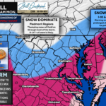
Good morning and happy Sunday. We are now fully into this winter storm, and conditions will continue to evolve quickly through the morning as snow gives way to sleet and freezing rain from south to north. Below is a breakdown of what we’re seeing right now, what to watch next, and where the biggest impacts are expected today.
What We Have Seen So Far
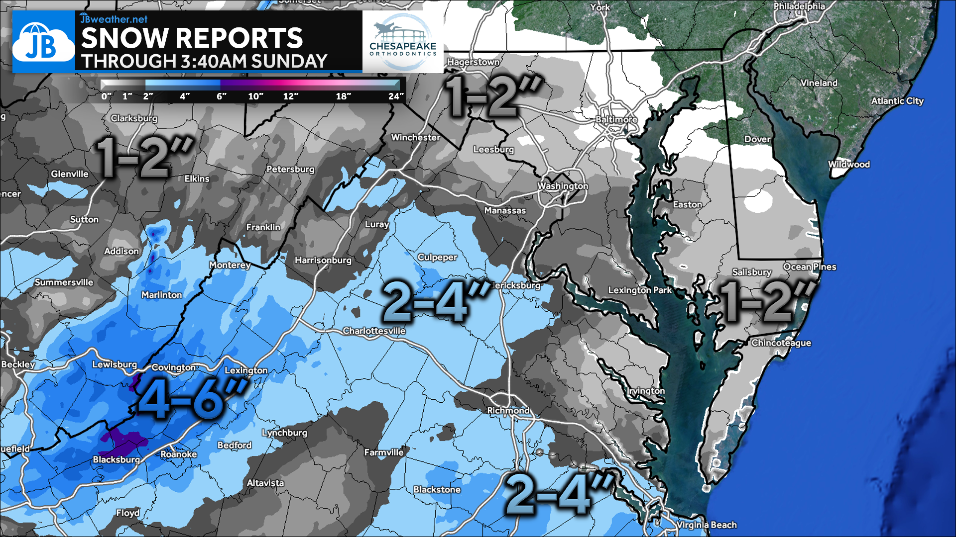
Snow overspread the region overnight, and early morning reports confirm that accumulation is already underway, especially across central and western Virginia where rates have been higher at times. Most locations have picked up 1–2 inches so far, with 2–4 inches already common farther south and west, and 4–6 inches reported in the higher terrain. These early totals line up well with expectations and set the stage for additional accumulation before the changeover later this morning.
Current Reports
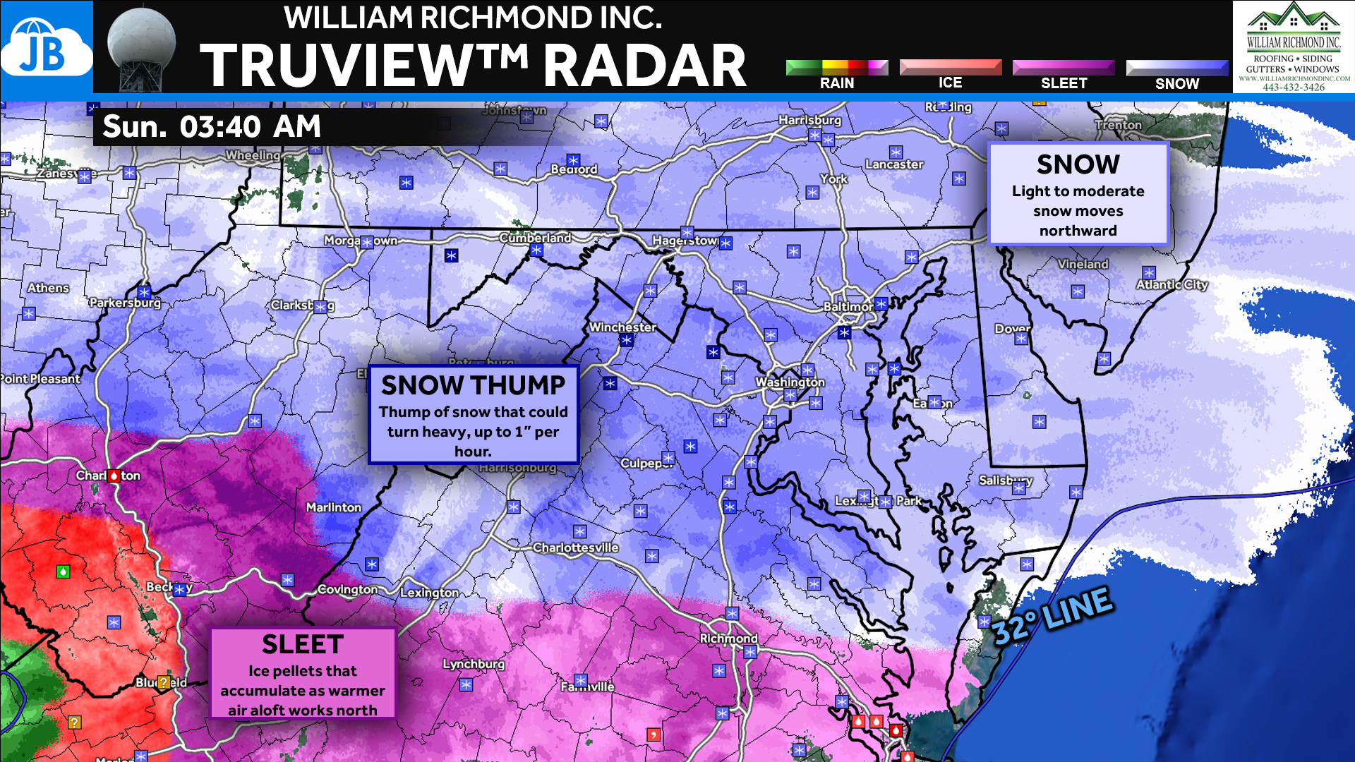
Radar shows snow firmly in place across much of the region, with pockets of heavier precipitation developing from central Virginia into southern Maryland. This is the “initial thump” we’ve been talking about — steady to occasionally heavy snow that will continue through the pre-dawn and early morning hours. Roads will become increasingly slick as snowfall rates increase, especially where temperatures remain in the teens and low 20s.
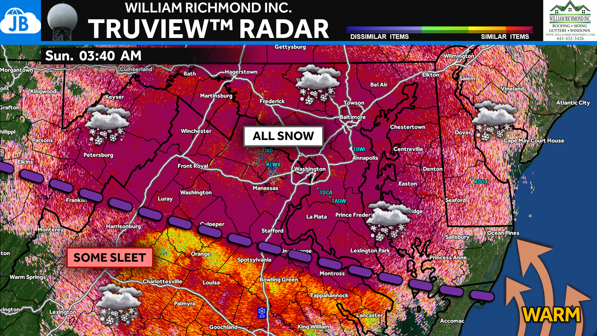
This graphic uses correlation coefficient, which is a radar product that helps us understand what type of precipitation is falling, not just how heavy it is. Snowflakes tend to be uniform in shape, so they return a high, consistent signal on radar. Sleet, on the other hand, is made up of ice pellets with mixed shapes and sizes, which lowers the correlation values and shows up as a different texture and color.
Because of that, correlation coefficient is one of our best real-time tools for tracking where snow is changing over to sleet. As we watch those lower correlation values creep northward, we can physically see the sleet line advancing, often before it becomes obvious on standard radar. Today, this tool will be key in monitoring how quickly sleet pushes north and which communities are next to see impacts shift from snow to ice.
Looking Ahead
The latest FutureView continues to show one more band of thumping snow pushing through right before the changeover, which could briefly produce snowfall rates near 1” per hour. After that, warmer air aloft works in, allowing sleet — and eventually freezing rain — to take over, especially southeast of I-95. Coastal areas remain the wild card, where marginal temperatures could briefly allow rain or freezing rain to mix in.
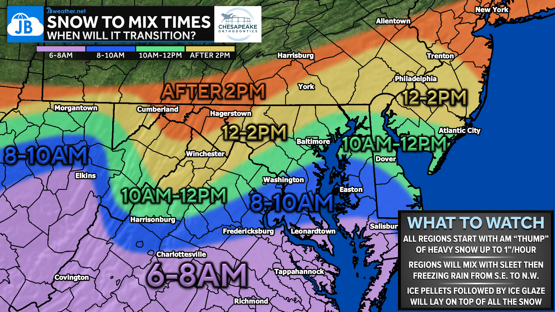
This graphic helps us track where snow is beginning to mix with sleet, and we are already seeing that transition start across parts of southern and southeastern Virginia, including areas near Richmond, Tappahannock, and Charlottesville. That sleet line will continue creeping northward through the morning, and we’ll be watching it closely as it approaches Southern Maryland. This is a key tool today, as even small northward shifts will have big implications for impacts.
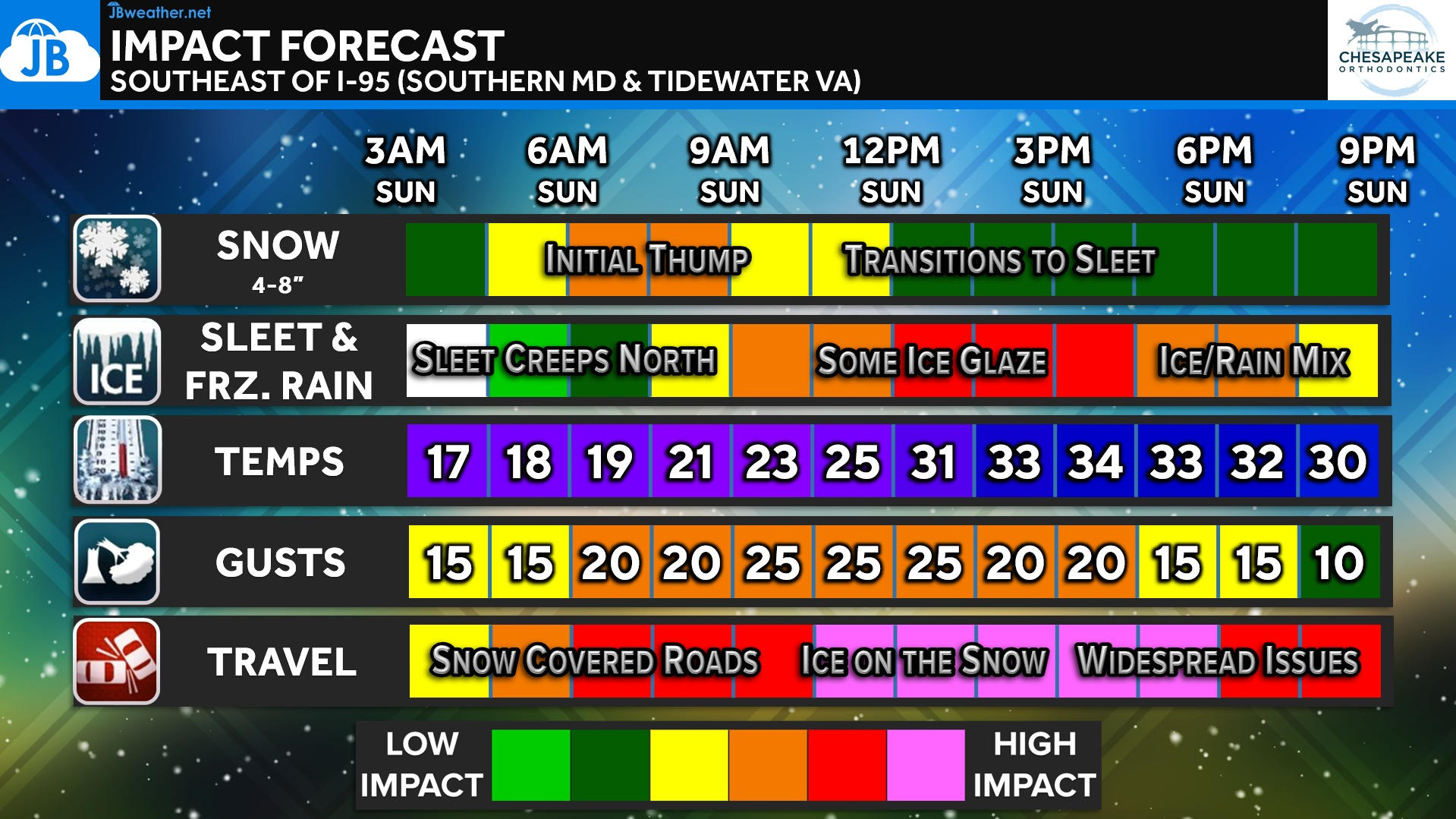
This timeline highlights why travel impacts will worsen through the morning and midday hours. Snow-covered roads early will be followed by ice on top of snow, which is one of the most dangerous combinations we see in winter storms. Even as snowfall tapers, conditions may actually worsen as sleet and freezing rain move in and temperatures remain near or below freezing.
Bottom Line
The storm is unfolding very close to plan. Most areas will pick up several inches of snow this morning before sleet and freezing rain create worsening travel conditions later today. Ice on top of snow will be the biggest concern, especially southeast of I-95 and closer to the Bay and coast. Stay weather-aware, limit travel if possible, and continue checking back for updates as we track the sleet and ice lines in real time.
Stay with JB Weather for the latest information on impacts here in Southern Maryland. You can always access my forecasts and updates here on the website, on Facebook, on Twitter, on Instagram, and on YouTube. JB Weather is the Mid-Atlantic’s Weather Leader, and I am working around the clock to keep you ahead of any storm!
Dr. Thomas Hao and Dr. Dylan Schneider offer comprehensive orthodontic services for all ages. Schedule your free consultation today. Visit www.SOMDBraces.com today for more information!
John Bordash
View More PostsJB Weather forecaster John Bordash is working around the clock to provide Southern Maryland, and neighboring communities, with accurate and reliable weather information.