Brought to you by Bill Oosterink, Realtor
A powerful coastal storm is set to impact the region tonight into Monday. While the snowfall forecast itself remains largely unchanged, the expansion of Blizzard Warnings and continued strong model agreement on a strengthening coastal low signal that impacts may be significant, especially east of the Bay and along the I-95 corridor.
This is now a nowcasting event, meaning mesoscale banding, storm strength, and exact track details will determine who sees the highest totals and strongest impacts over the next 12–24 hours.
SETUP: COASTAL LOW DRIVES THE IMPACTS
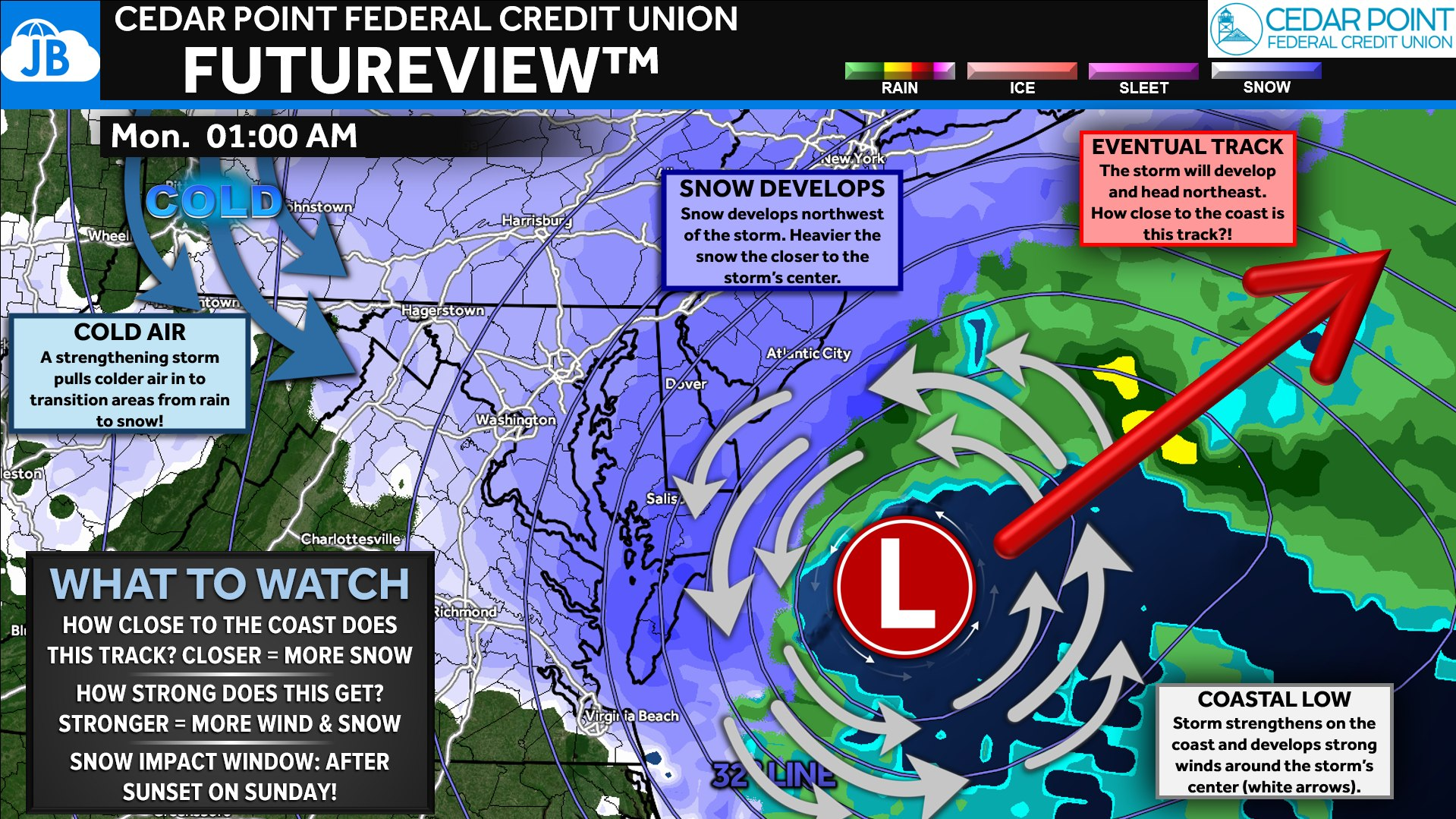
A strengthening coastal low will track northeast just offshore today and tonight. The closer a location sits to this track, the higher the impacts will be — both in snowfall and wind.
Cold air wrapping into the storm will allow the rain we see today to transition to snow tonight from northwest to southeast, with the most intense snowfall expected on the northwest side of the storm’s center. Areas along and east of the Bay remain best positioned for the highest impacts given proximity to the storm’s track and strongest forcing.
TIMING: RAIN TO SNOW TODAY, HEAVIEST TONIGHT
The overall timing remains unchanged. Widespread rain this morning will gradually mix with snow through the afternoon as colder air works in. By this evening, most areas will be snow, with the main accumulation window running tonight into early Monday.
Banding will be the biggest forecast variable. We know the heaviest snow will fall east of the Bay, but key questions remain: How far west does that heavy band extend? And will additional deformation bands set up along or west of I-95? Those answers will determine who overperforms and underperforms expectations.
WARNINGS: WINTER STORM & BLIZZARD ZONE EXPANDS NORTHWEST
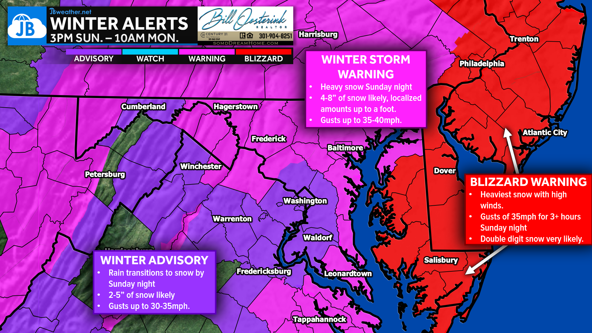
Warnings remain largely unchanged, but Blizzard Warnings have expanded northwestward to include most of Delmarva and now the Philly metro area, extending north toward NYC and Boston.
Winter Storm Warnings remain in place along the Bay, northern Maryland into southern Pennsylvania, and the mountains. Advisory areas inland will still see widespread snow but with lower impacts overall.
SNOW FORECAST: STILL ON TRACK, BUT BANDING WILL MATTER
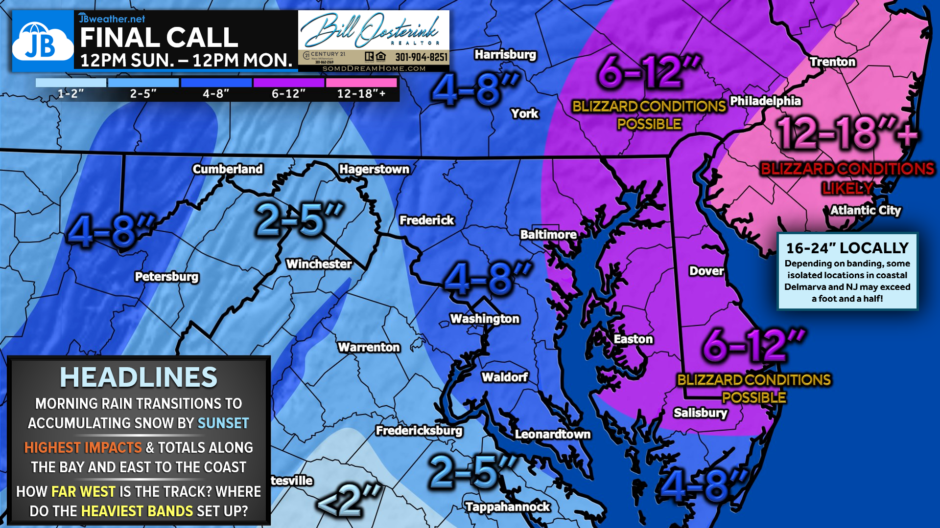
The snowfall forecast remains largely unchanged. However, localized higher and lower amounts are very likely due to mesoscale banding that cannot be pinpointed ahead of time.
Those along the Bay have the best regional shot at seeing at least 6 inches. Coastal Delmarva and coastal New Jersey could approach two feet where the heaviest bands persist. Philadelphia remains in a boom zone where totals could climb into the 12–18 inch range if the storm tracks favorably.
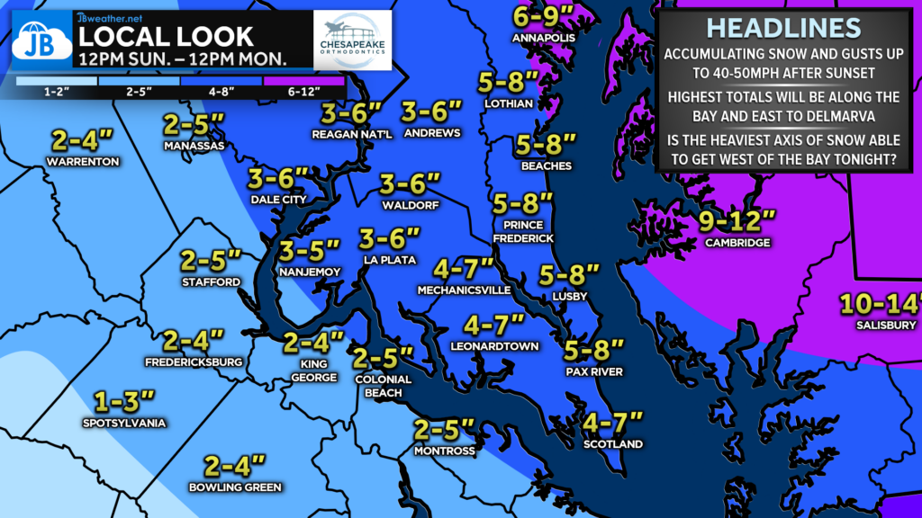
Across Southern Maryland, rain will transition to snow late this afternoon and evening as colder air works in and the coastal storm strengthens. Most areas should see accumulating snow tonight, with higher totals likely closer to the Bay and Eastern Shore where stronger bands may develop, while inland locations may see somewhat lighter amounts.
WIND FORECAST: STRONGEST TONIGHT INTO MONDAY MORNING
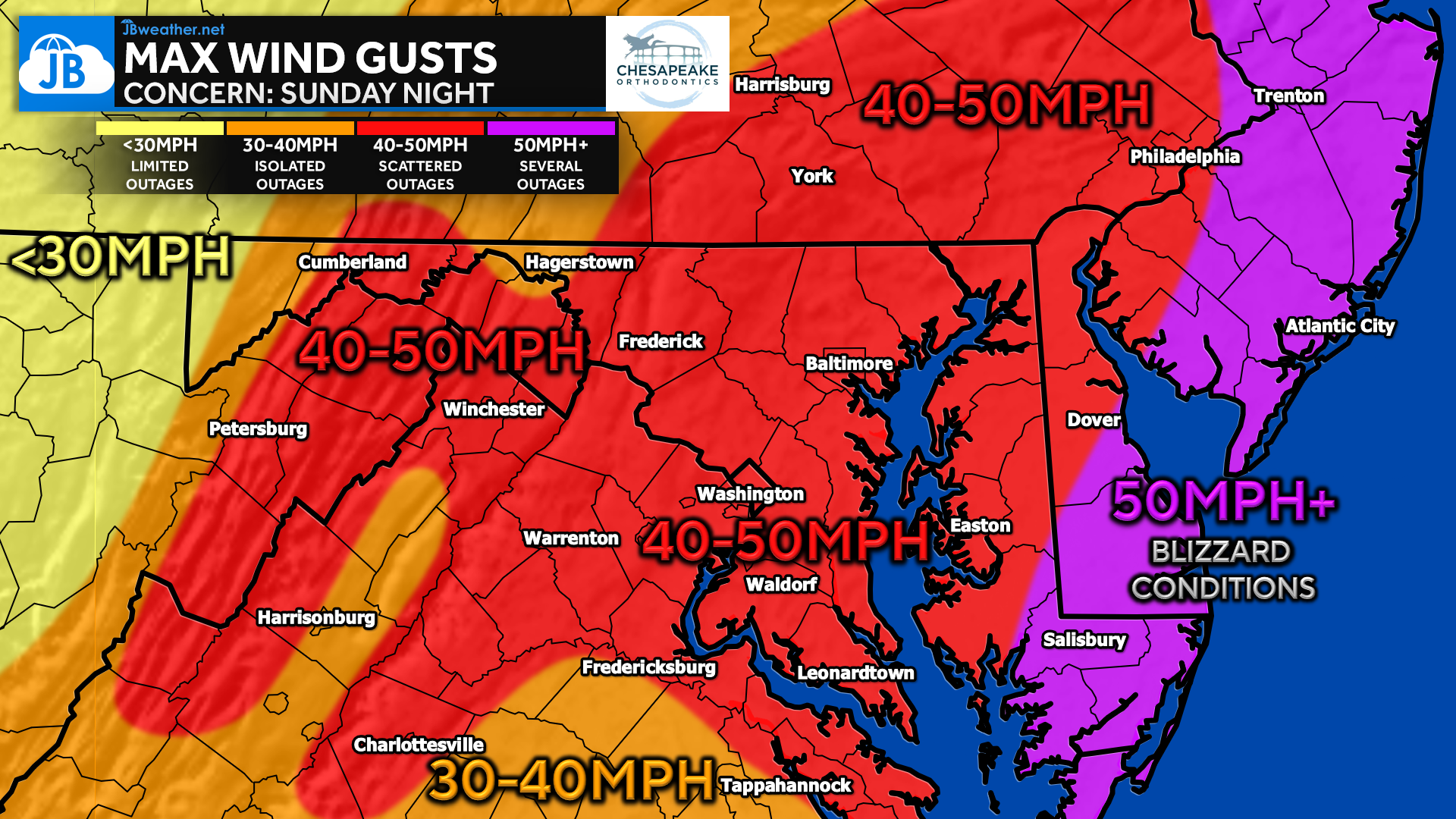
Winds will steadily increase as the coastal storm strengthens, peaking tonight into Monday morning. Gusts of 40–50 mph or higher are likely regionwide, with even stronger winds near the coast.
These winds combined with heavy snow may lead to reduced visibility, blowing snow, and scattered power outages — especially east of the Bay.
OVERALL IMPACT: WORST CONDITIONS TONIGHT INTO MONDAY
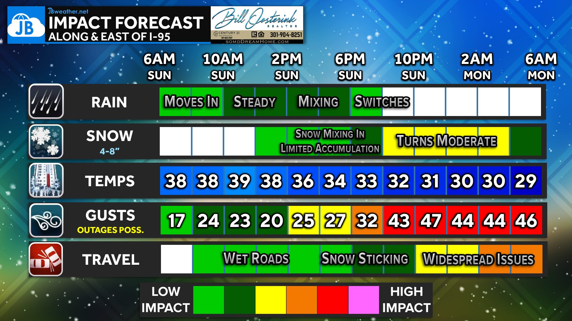
The biggest impacts arrive tonight as snowfall rates increase and winds intensify. Travel conditions will deteriorate rapidly overnight and remain difficult into Monday morning.
Widespread school closures Monday appear likely, with lingering impacts possibly extending into Tuesday depending on snowfall totals and cleanup conditions.
KEY TAKEAWAYS
• 🌧️ Rain this morning → mix this afternoon → heavy snow tonight
• ❄️ Heaviest snow east of the Bay, but bands could shift totals locally
• 🌬️ Winds 40–50+ mph tonight could cause outages and blowing snow
• 🚫 Travel impacts peak overnight into Monday morning
• 📚 Closures Monday likely… possibly lingering into Tuesday
FINAL CONCLUSION
Confidence is now high that this storm will bring impactful winter weather to much of the region, with the most significant conditions expected tonight into Monday morning. While the overall forecast remains on track, localized heavier bands will determine where the highest totals ultimately occur. Travel disruptions, closures, and power outages are all possible, especially east of the Bay where snow and wind will be strongest. Continue to monitor updates through the day, as nowcasting will be key in tracking where the worst conditions develop.
Stay with JB Weather for the latest information on impacts here in Southern Maryland and across the Mid-Atlantic. You can always access my forecasts and updates here on the website, on Facebook, on Twitter, on Instagram, and on YouTube. JB Weather is the Mid-Atlantic’s Weather Leader, and I am working around the clock to keep you ahead of any storm!
Brought to you by Bill Oosterink, Realtor. Buying. Selling. Investing. Ready when you’re ready! Check out www.somdDreamHome.com today!
John Bordash
View More PostsJB Weather forecaster John Bordash is working around the clock to provide Southern Maryland, and neighboring communities, with accurate and reliable weather information.

1 thought on “Final Call: Significant Coastal Storm Set to Hit Mid-Atlantic Tonight”
Comments are closed.
I can only say YIKES!