Brought to you by Chesapeake Orthodontics
Since Hurricane Elsa developed and made landfall in early July, the Atlantic has been virtually dead. Strong wind shear and frequent bouts of dry Sharan air moving off the African continent have kept a lid on things for the past month. As we begin to enter into the heart of hurricane season though, we are beginning to see things ramp up. This morning, we have two tropical entities that I am watching. We have Tropical Storm Fred in the Caribbean and Invest 95-L, which may look to become Grace down the road, in the central Atlantic.
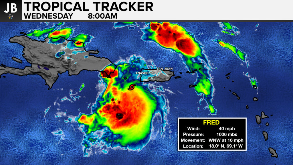
This morning, Tropical Storm Fred is moving south of Puerto Rico and getting ready to move onshore in Hispaniola, which houses Haiti and the Dominican Republic. As things stand now, Fred is not especially strong, barely making Tropical Storm status. The mountainous island of Hispaniola will help to keep the storm weak over the next 18-24 hours.
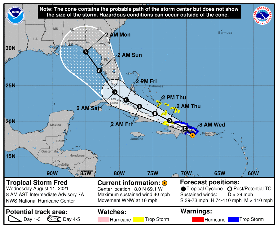
Tropical Storm Fred, or what is left of it, will likely emerge over the Southern Atlantic tomorrow as an even weaker system. Current steering patterns will help guide the storm northwestward off of the Cuban coastline and up the Bahamas. The storm will then head into the Gulf of Mexico before making an eventual landfall along the Eastern Gulf Coast late this weekend or early next week.
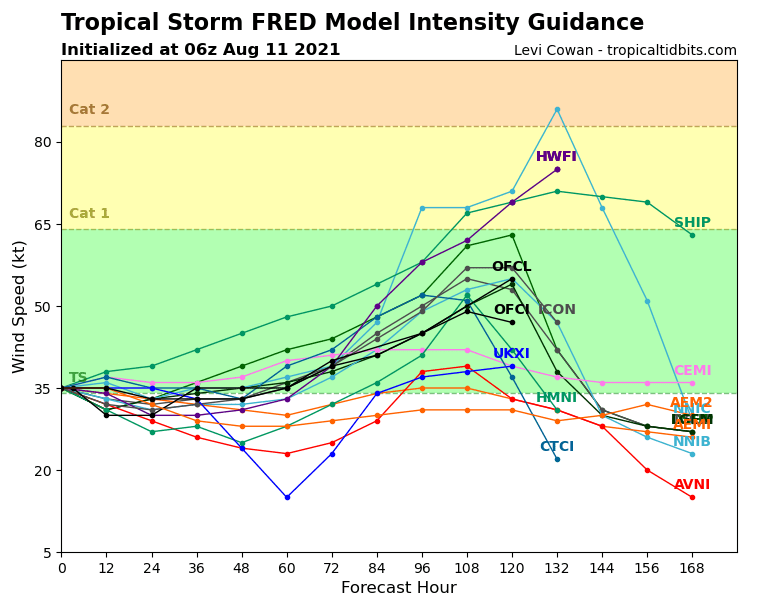
Current intensity guidance shows that once Fred emerges over the warm waters of the southern Atlantic, in about 24-48 hours, that the storm should begin to intensify. The waters along the Bahama chain and in the Gulf of Mexico are both very warm– almost bath-like. These warm waters should help the storm gradually intensify as it moves northwestward. By about 72-96 hours, the storm will likely be in the Gulf which is when it will likely strengthen the most. The official forecast is for Fred to approach the Florida panhandle early Monday morning as a strong tropical storm with winds near 65 mph. However, some of our models make the case for Fred to potentially strengthen into a low-end hurricane before landfall.
The chart below depicts all of this. Each colored line represents each model, with the X-axis representing the forecasted time in hours. The Y-axis, with the associated colored background, shows strength.
It is unclear whether the Mid-Atlantic will see much from whatever remains of Fred. If we were to, it likely would not impact us until mid-next week. That is still 7 days out, so a lot can and will change.
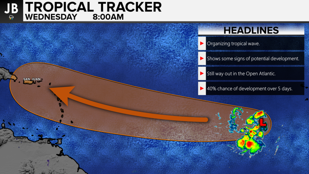
The other entity we are watching currently is Invest 95-L. This is not an official tropical system yet, hence the lack of a name. With that said though, we are watching this area closely as tracks eastward. This system has about a 40% chance of development over the next 5 days, and these odds have been increasing. This tropical wave is a healthy one and will have plenty of time to develop over the warm, open Atlantic.
This system will look to get near the Lesser Antilles, in the same region where Fred is now, by late this weekend. Whether or not this system is an official tropical storm remains to be seen, but many models do show this as a strengthening system by that point. The future of this system from that point is highly uncertain. A multitude of different steering forcing and atmospheric dynamics will be at play which makes it difficult to say with any confidence what will happen. With that said, I do think that this could be a potential system to watch in the long term.
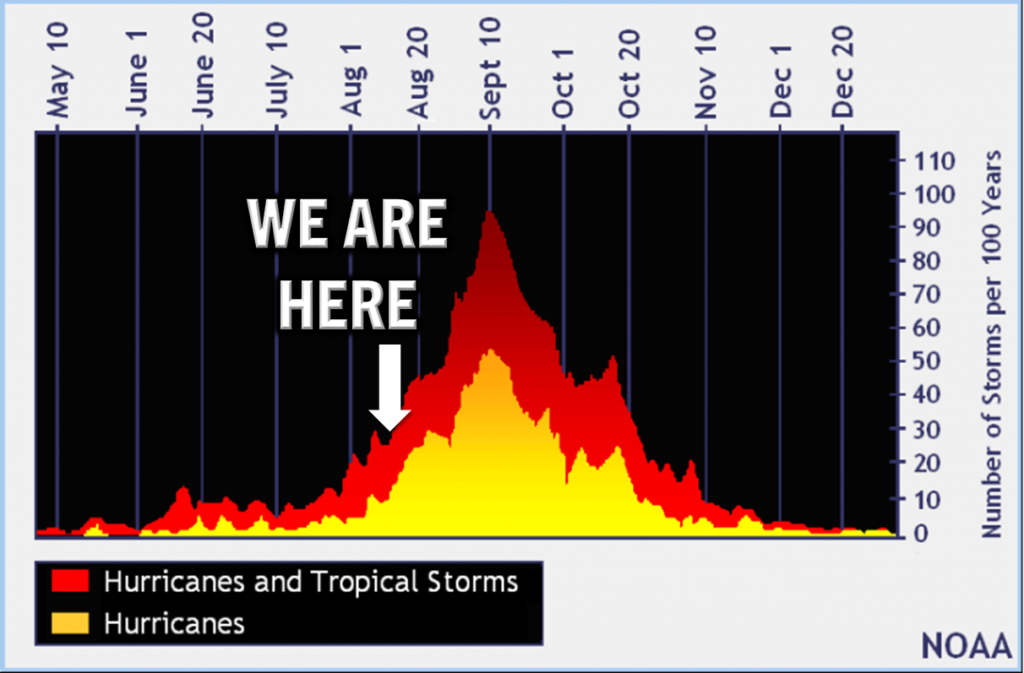
As we enter the heart of hurricane season, we will have to keep an eye on the tropics. The Atlantic is slowly awakening, and we are likely in store for a busy 6-8 weeks! Stay with JB Weather for the latest information on Southern Maryland weather. You can always access my forecasts and updates here on the website, on Facebook, on Twitter, and on YouTube.
-JB
Dr. Thomas Hao and Dr. Dylan Schneider offer comprehensive orthodontic services for all ages. Schedule your free consultation today. Visit www.SOMDBraces.com today for more information!
John Bordash
View More PostsJB Weather forecaster John Bordash is working around the clock to provide Southern Maryland, and neighboring communities, with accurate and reliable weather information.