Brought to you by Sonder Studios
A rare and potentially impactful severe weather risk is expected to unfold across the Mid-Atlantic on Monday. While the overall forecast has not changed significantly, the timing of storms has become clearer throughout the day. Many school districts across the region have already announced early dismissals ahead of the highest risk period Monday afternoon.
A rare Level 4 “Significant Risk” for severe weather remains in place, and residents should stay weather aware tomorrow.
Setup: Strengthening Storm System
A strong low pressure system moving through the Great Lakes will push a powerful cold front toward the Mid-Atlantic on Monday. As this system approaches, warm and increasingly humid air will surge northward into our region.
Morning rain will likely move through early in the day, but how quickly skies clear afterward will be critical. If the atmosphere can warm and destabilize during the late morning and early afternoon, it will provide fuel for thunderstorms to rapidly strengthen ahead of the cold front.
The front itself will act as the trigger for a powerful line of storms, which is expected to organize and intensify as it crosses the Appalachians and moves toward our region during the afternoon.
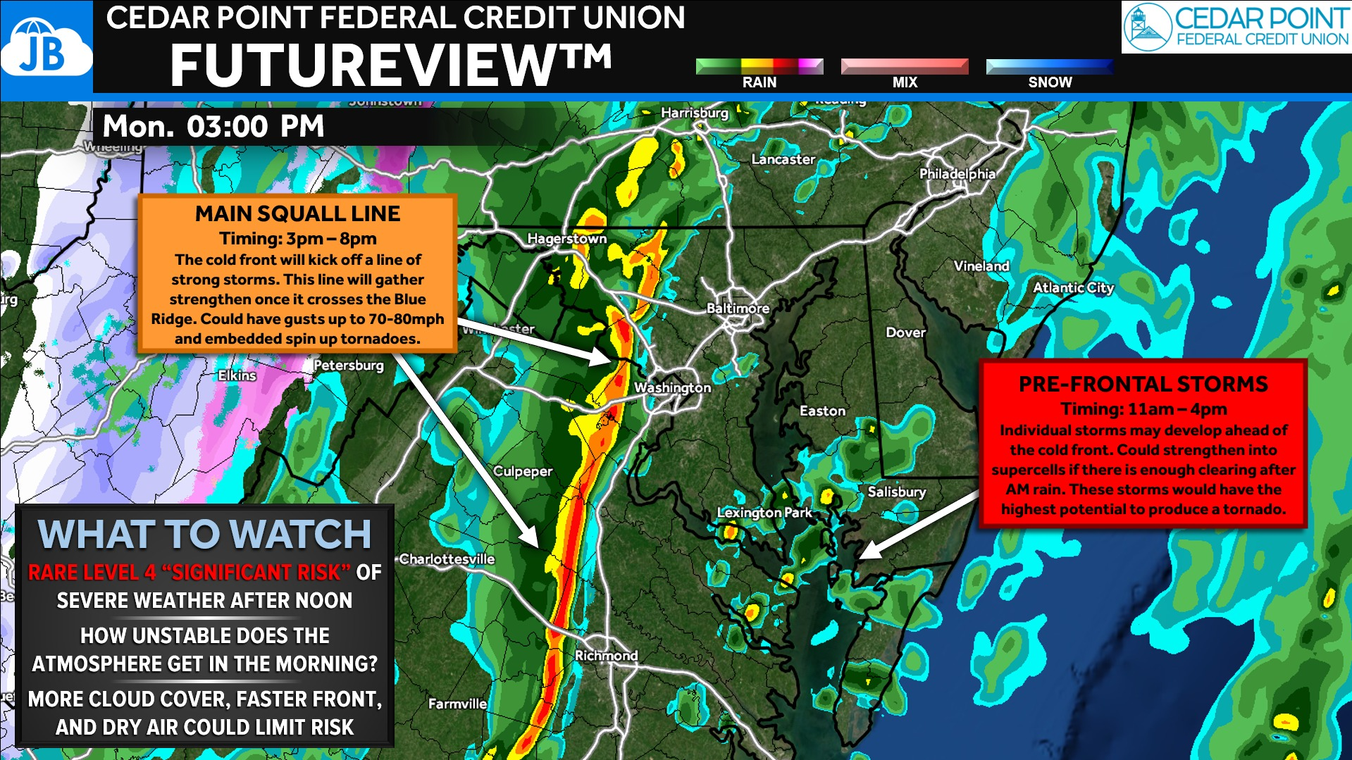
FutureView Timing Breakdown
The FutureView model highlights how this system may unfold hour by hour Monday. Morning showers move through early in the day before conditions begin to destabilize late in the morning. By midday and early afternoon, isolated storms could begin developing ahead of the approaching cold front.
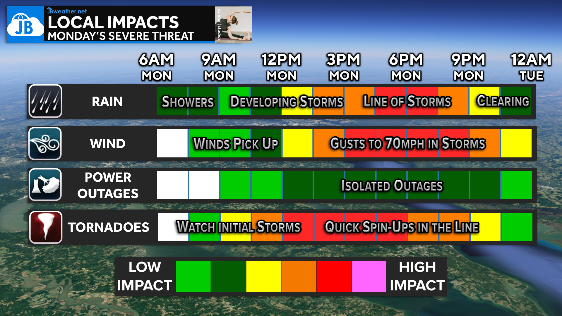
🌧 Morning (7–11 AM): Periods of rain and showers move through the region. This activity will be important because how quickly skies clear afterward will determine how unstable the atmosphere becomes.
🌩 Late Morning–Early Afternoon (11 AM–4 PM): A few isolated storms could develop ahead of the main front. If enough clearing occurs, some of these storms could rotate and attempt to produce a tornado.
⚡ Main Severe Line (3–8 PM): A squall line of strong storms will move through as the cold front arrives.
This line could produce widespread damaging winds of 70–80 mph and embedded spin-up tornadoes.
📉 After 8 PM: Storms push east and conditions quickly improve.
Severe Weather Outlook
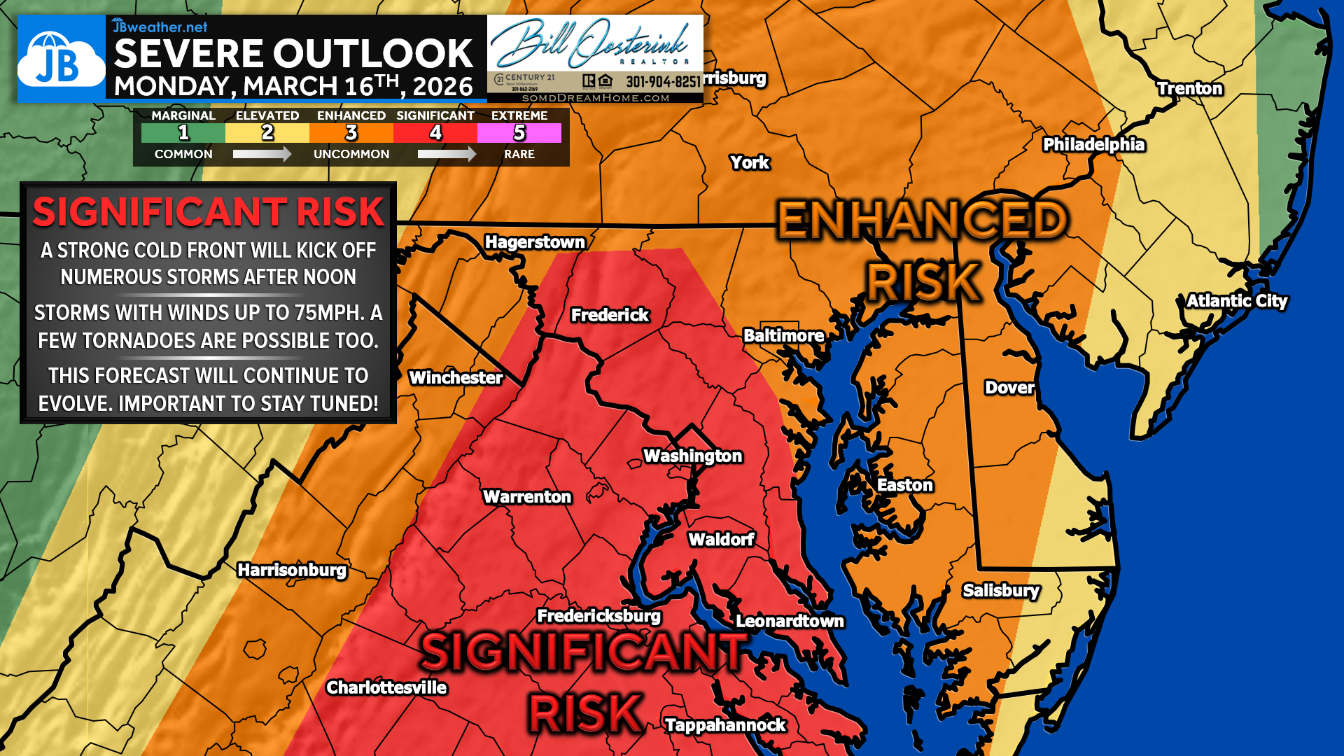
The Storm Prediction Center continues to place much of the region under a rare Level 4 “Significant Risk” for severe weather Monday.
This level of risk is extremely uncommon in the Mid-Atlantic, typically issued only once every several years. It signals that conditions are favorable for numerous severe storms, some of which could become intense.
The greatest risk will develop Monday afternoon into the early evening, when the atmosphere is expected to be most unstable and the approaching cold front provides strong lift.
Severe Threats
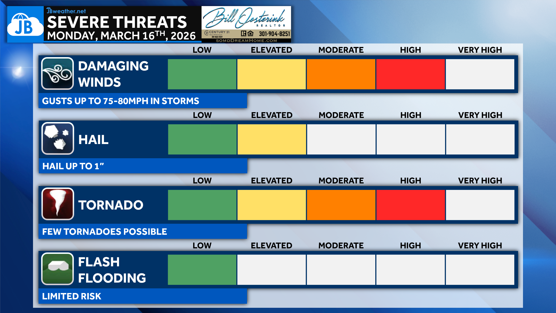
Damaging winds are expected to be the primary threat with this system. The Storm Prediction Center has issued an almost unprecedented 60% wind risk for the region, indicating a high likelihood of widespread severe wind reports.
Wind gusts within storms could reach 75–80 mph, especially within the main line of storms.
There is also a rare 15% tornado risk, which is significant for our region. Tornadoes could occur in two ways:
• Individual storms developing ahead of the main line during the early afternoon
• Quick spin-up tornadoes embedded within the squall line
Hail will also be possible with stronger storms, though the primary concerns remain damaging winds and isolated tornadoes.
Flash flooding appears to be a limited concern due to the fast-moving nature of the storm system.
Storm Impacts

With the highest severe weather threat expected Monday afternoon, many school districts across the region have already announced early dismissals or schedule changes. All Southern MD schools have annoced early dismissals of at least 2-hours.
These decisions are being made to ensure that students and buses are not traveling during the peak severe weather window. Stay up to date on school alerts at the link below
Residents should expect a more active afternoon commute, and businesses or community organizations may also adjust schedules depending on how conditions evolve.
Putting it all Together
Monday’s severe weather threat will likely unfold in several stages, beginning with morning showers before conditions become more favorable for storms during the afternoon. If the atmosphere is able to destabilize after the morning rain moves out, storms could begin developing ahead of the cold front late morning into early afternoon. The highest impact period looks to be mid-afternoon through early evening, when a strengthening line of storms moves through the region. This line could produce widespread damaging winds and a few tornadoes before pushing offshore Monday night. While not everyone will see severe weather, this is a rare setup for our region and one worth taking seriously.
Key Takeaways:
• ⏰ Storm window: Late morning through evening, with peak risk 3–8 PM
• 🌪 Isolated storms midday could rotate and attempt to produce tornadoes
• 💨 Main squall line may bring 70–80 mph wind gusts and embedded tornadoes
• ⚠️ Rare Level 4 severe weather risk for the region
• 📱 Stay weather aware Monday afternoon and have a way to receive warnings
Stay with JB Weather for the latest information on impacts here in Southern Maryland and across the Mid-Atlantic. You can always access my forecasts and updates here on the website, on Facebook, on Twitter, on Instagram, and on YouTube. JB Weather is the Mid-Atlantic’s Weather Leader, and I am working around the clock to keep you ahead of any storm!

SONDER℠ Yoga studio. Barre studio. Fitness Studio. Classes, events & education for being well. Sonder is a mindful community, and you are invited. 5+ years in Calvert County, MD. We are grateful for your trust.
John Bordash
View More PostsJB Weather forecaster John Bordash is working around the clock to provide Southern Maryland, and neighboring communities, with accurate and reliable weather information.