Brought to you by G&H Jewelers, Inc.
Overnight, our computer guidance really became locked in on the storm threat late tonight into Monday. Confidence is growing that Monday will be a snowy day for much of the region. Based on the latest data I have been reviewing all night, it looks likely that this storm will track further northwest and have more precipitation with it than anticipated. Much of Southern Maryland now sits in a good zone to potentially see moderate snow from this southern sliding system. Areas north of the DC metro area may struggle to see much at all, while areas between DC and Richmond may be in the bullseye.
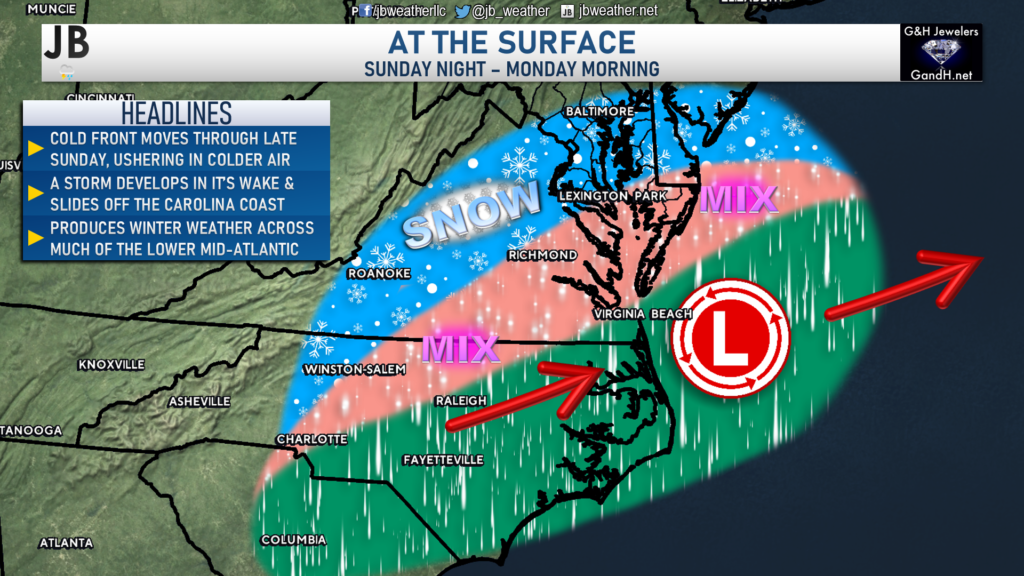
With overnight trends pointing to an increased snowfall forecast, the National Weather Service has issued a Winter Storm Watch for the areas shaded in blue for Monday morning. This is where impactful snow looks increasingly likely to fall. Later on today, this map will be updated with additional Winter Weather Advisories (where minor snow totals are possible) and Winter Storm Warnings (where the heaviest totals look likely to fall).
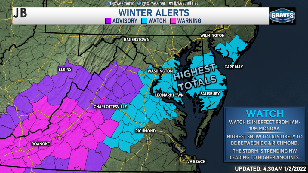
Timing of Precip & Colder Temperatures
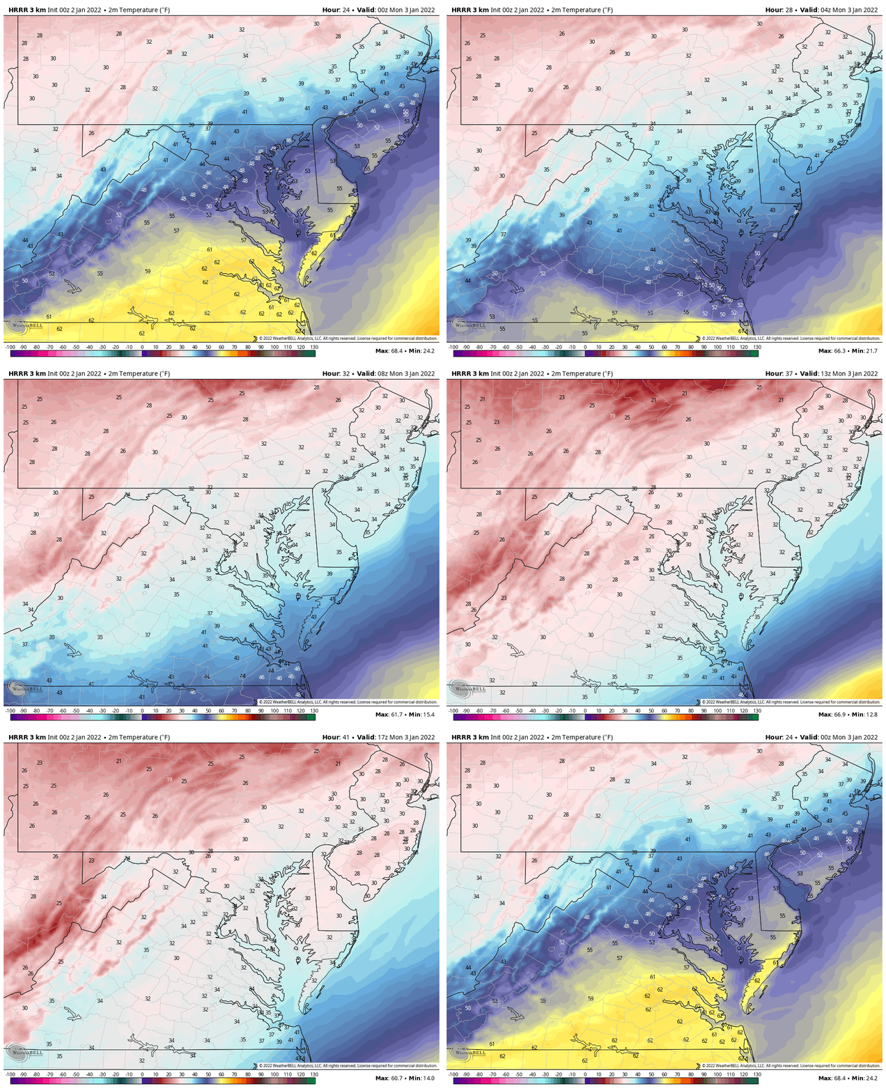
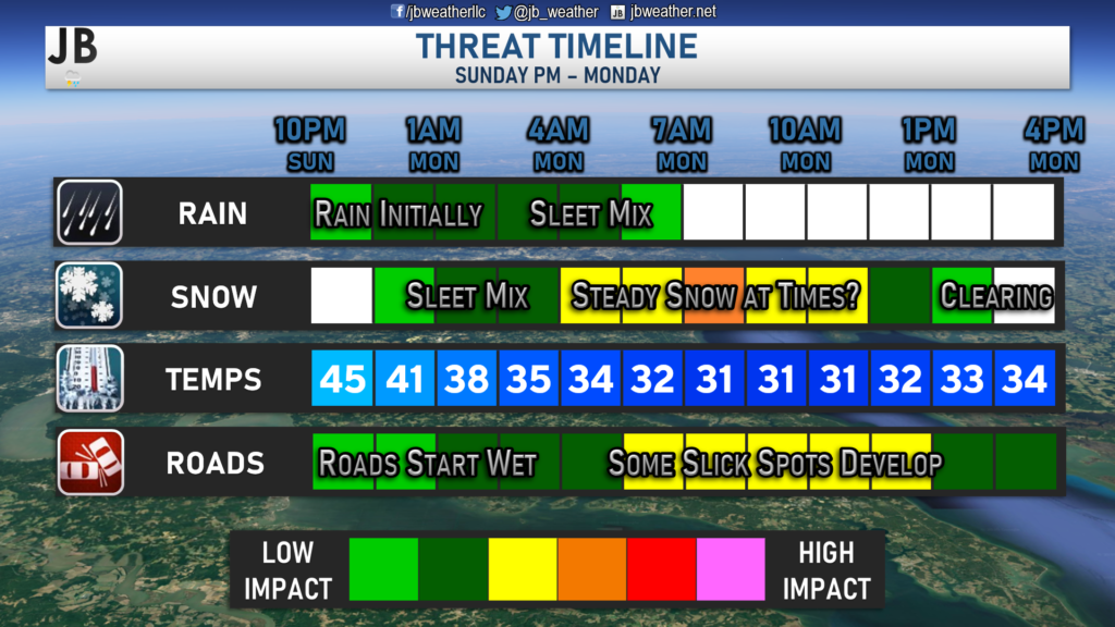
Overnight, we saw a surge of warm air push many areas into the 60s as rain moved through. Much of today will be spent with temperatures in the 60s ahead of a cold front. Once that cold front moves through the region later this afternoon and evening, temperatures will fall quickly! Shown above is a depiction of the temperatures swing we could see between Sunday evening and Monday morning. Gusty northwest winds will help deliver the shot of cold air, potentially cooling temperatures by around 30° in just about 12 hours.
In terms of the precipitation, our Chesapeake’s Bounty Futurecast (shown above) shows that precip will look to move into the region around 10pm Sunday night. Temperatures will still be in the 40s and 50s at this time, so any precip would likely start as all rain. However, as colder air filters in the region overnight, the rain will change over to snow from north to south. By midnight, we could start seeing some sleet and snow work down into Southern MD. The transition to snow should be quick for much of our local region. The one area that may have some issues with the change over would be the warmer zones in southern Calvert and southern St. Mary’s Counties, which is shown below.
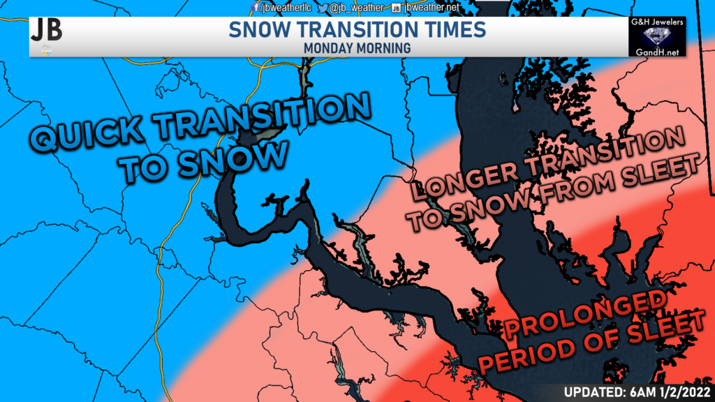
While I do expect all areas to switch over to snow by sunrise, areas in the light pink may see an hour or two of sleet before the transition, whereas areas in blue should not see much more than an hour of sleet. Any time spent with sleet will cut down on snow totals. While the northwest trend has helped to push heavier snow into our area, it also pushes the sleet line further northwest. Any additional ticks northwest could lead to the sleet area moving further north as well.
We should see a few hours of light to moderate snowfall across the region between sunrise and lunchtime. Our Futurecast model even has some spots of heavy snow. While I think that may be overdone a tad, it does show the possibility of localized banding leading to some locally higher snowfall totals. This system should push out of Southern Maryland by early to mid-afternoon.
Accumulation Map
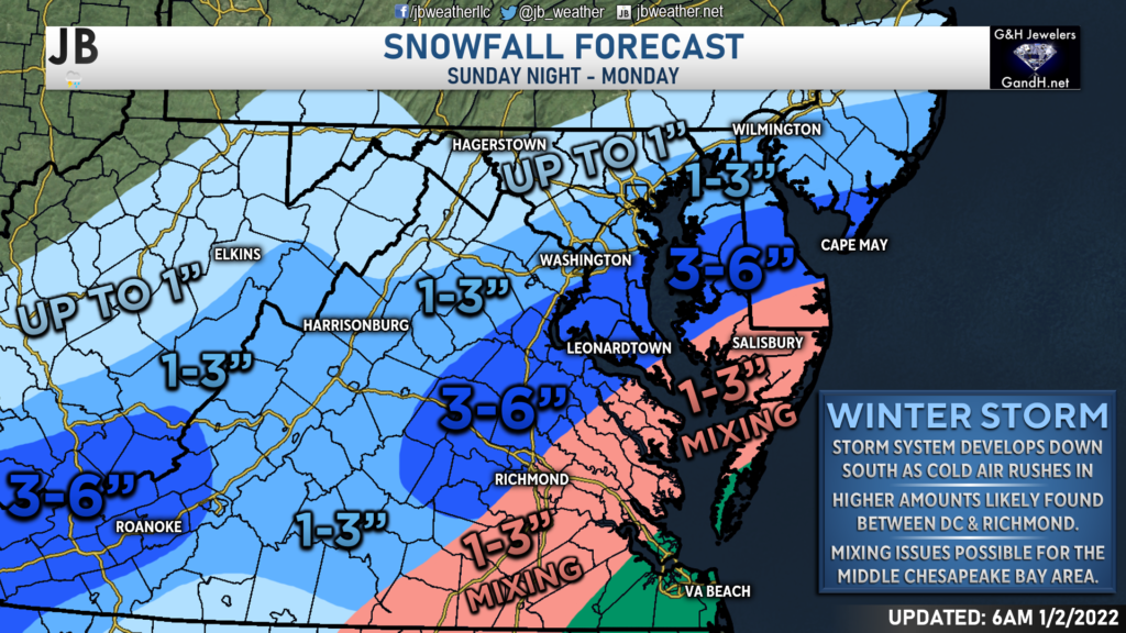
The northwest trend of this storm has helped push higher snow totals northward into Southern Maryland. The highest totals are now likely to be focused between the DC metro area and the Richmond metro area. I believe that this is the region that could see 3-6″ of snow. If heavier snow bands do set up, there are a couple of communities in this zone that could see locally higher amounts. However, I expect that to be the exception and not the rule. Lighter amounts will be found north of DC, thanks to lighter precipitation. The Tidewater of Virginia, Northern Neck, and lower Delmarva Peninsula will likely have mixing issues that cut down on those totals.
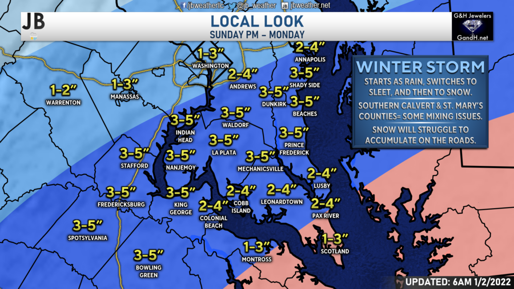
Locally, the highest totals will likely be found from Shady Side-Dunkirk-Brandywine down to Prince Frederick-Mechanicsville-Newburg. This is the zone that will likely have minimal issues with sleet and should see some moderate snows. South of there, totals are a smidge lower as these spots may have issues with sleet mixing in for a prolonged period. The zone where this will affect snow totals the most will likely be south of Lexington Park. Totals drop off as you approach DC and Annapolis, where only an inch or two may be possible.
Regional Impacts
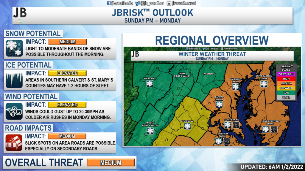
This storm is looking like it may bring more moderate impacts to the region. This is because the threat of moderate snow has increased, which will lead to higher accumulations. The ice potential for Southern MD has increased a tad, granted is mainly for those southern zones that we talked about. While I am not expecting freezing rain in that area, there could be 1-2 hours of sleet that accumulate up to a quarter or half an inch. Winds will be gusty on Monday as colder air rushes into the region.
I am now also expecting medium roadway impacts. While most of the accumulation will occur on grassy and colder surfaces, we could see slick spots form– especially on secondary roads. Roadway temperatures will be warm after such a warm weekend. For that region, I think the main roads should be fine, initially. However, if we see moderate to heavy bands of snow set up, they may overcome those warm road temps as the snow would pile up quicker than it could melt. This is something to keep in mind, especially north of Prince Frederick and La Plata. This will likely pose impacts on the Monday morning commute and could impact school and business schedules. I will have an official “School Odds” forecast out later this evening for our region. However, one would have to imagine that an increasing snowfall forecast would bode well for those looking for a snow day!
Storm FAQs
How confident are you in your forecast? My confidence in this forecast is growing. Confidence is above average that we will get at least some accumulating snow, mainly due to the amount of cold air that will be diving into the region and the abundant moisture associated with this storm. This cold dry air to the north is causing this storm to take a more southerly track, which bodes well for Southern Maryland snow hounds.
Where will the heaviest snow fall?
The highest snow totals will be south of the DC metro region, closest to the area of the low pressure. Some spots between DC and Richmond may pick up as much as 3-6″, and that includes most of Southern MD.
When will the snow start?
Current guidance shows that the snow may begin very early Monday morning, likely just after midnight. However, rain may begin falling around 10pm Sunday night before we switch over to snow.
When will the heaviest snow fall?
Probably during the morning hours between sunrise and lunchtime south of the DC metro region. Some bands of moderate to even heavy snow may impact area during this time.
When will the snow end?
The storm looks to last longer in duration than earlier thought. Current indications show that the snow should be winding down after lunchtime, and should be out of no later than sunset.
How much snow will I get at my house? Check out the accumulation map. Generally, I’m expecting 3-6″ for most of the region, with lower totals across southern Calvert and southern St. Mary’s (thanks to sleet) and north of DC (thanks to lighter precip rates).
Could more or less snow fall than currently forecast?
Absolutely. In order for more snow to happen, we would need the storm to track further northwest, which would allow heavy precipitation to develop right over Southern MD. Colder temperatures would also lead to more snow, as opposed to sleet, for southern zones. On the other hand, if the storm takes a slight jog to the south, or if the air is not as cold, many areas will struggle to see much. In light of these plausible scenarios, here’s my assessment of snowfall probabilities:
10% chance: Nothing
35% chance: 1-3″
45% chance: 3-6″
10% chance: 5-8″
As you can see, we have near equal chances of seeing nothing or of seeing 1-3″ or 3-6″ of snow in our area. The trend has been for higher totals, hence the edge is being given to 3-6″. There is an outside chance that we see more than 6″, but I think that chance is very low and likely to be isolated.
Will the snow stick? It is likely that we see snow accumulation on grassy areas, and on colder surfaces. While it can snow a day after getting into the 60s (it has happened many times before), it is hard to get that snow to stick to the warm blacktop on roadways. Snow will have a hard time accumulating on the main highways, unless a heavy band sets up. Secondary and back roads may see slick spots develop by mid-morning though.
Any chance of a wintry mix of freezing rain or sleet? While freezing rain is unlikely, the chances of seeing sleet with this storm are moderately-high. Most areas will likely see a period of sleet as the rain transitions to snow. Areas north Route 231 (running from Prince Frederick to La Plata) will likely only see an hour at a max of sleet before getting in on snow. Areas south of Route 231 may see a couple of hours of sleet with this storm before the switch over to snow happens. Sleet pellets accumulate more like snow and not like freezing rain. While it can make surfaces slick, I am not expecting an ice glaze with this event. Some southern zones though could see up to a half-inch of sleet pellets with this storm.
Summary
Chances are high that Southern Maryland will see its first winter storm of the season! We have a developing system sliding to our south as cold air filters into the region Monday morning. Areas south of DC are the areas that are the most likely to see snow out of this setup. This storm has trended further north and west, with a lot more moisture, leading to increased snow chances in Southern MD. Accumulation and impacts are likely across Southern MD for Monday morning. Right now, 3-6″ seem probable for most, with communities in southern Calvert and southern St. Mary’s Counties seeing more like 2-4″. Winter weather impacts are likely on Monday, which may hinder the morning commute. I will have School Odds out later this afternoon (hint hint, 3-6″ of snow normally bodes well for a snow day). However, any shifts to the northwest with this storm would lead to higher totals and higher impacts.
Stay with JB Weather for the latest information on impacts here in Southern Maryland. You can always access my forecasts and updates here on the website, on Facebook, on Twitter, and on YouTube. JB Weather is Southern Maryland’s Weather Leader, and I am working around the clock to keep you ahead of any storm!
-JB

Shop G&H Jewelers Today for Loose Diamonds, Fine Diamond & Colored Gemstone Jewelry, On-site Custom Jewelry Design (CAD) & Manufacturing, Jewelry Repair and GIA Graduate Gemologist Appraisal Services. Third Generation Family Owned & Operated Since 1965.
