After severe thunderstorms races through Southern Maryland Friday night, the National Weather Service sent damage teams to our region to survey the aftermath of the storms. In their findings, The National Weather Service has confirmed that a tornado did, indeed, spawn a couple of different tornadoes. The first time was in central Virginia, just north of Richmond. The second time was when the storm moved through the heart of Southern Maryland Friday night. The confirmed tornado is the first one to strike Southern Maryland this year.

The National Weather Service finds show that this spawn a tornado in several different instances. The first time occurred as the storm traveled approximately 10 miles, likely in a discontinuous path, from near Dabneys, VA to near Beaverdam, VA between 6:22PM – 6:47PM. The initial tornado was rated as an EF-0 with max winds of 85mph.
There were a few instances of noticeable damage with this initial path. First, the tornado caused noticeable damage to a farm off of Crewsville Road in Eastern Louisa County; damaging multiple trees and a chicken coup. Then, the next area of noticeable damage was along Pleasant Mill Road where multiple trees were snapped, one landing on a home. Light tree and limb damage continued off to the northeast along Beaver Dam Road, before all damage came to an end near Beaver Dam Road and Tyler Station Road, south of Beaverdam.
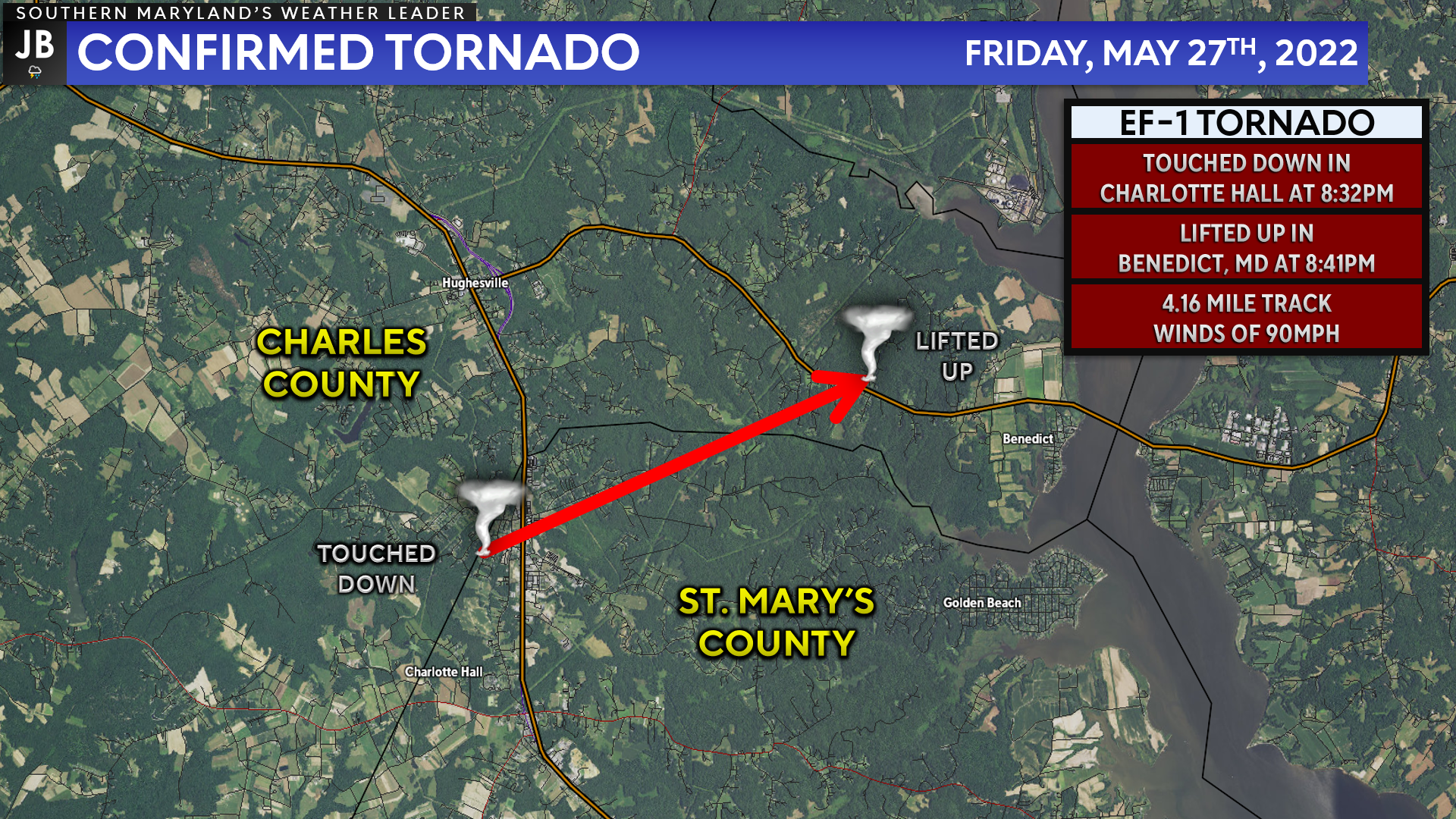
This storm then went on to produce a second tornado after crossing the Potomac River and tracking through Charles County. The National Weather Service has found that between 8:32PM and 8:41PM, this storm produced an EF-1 tornado, with maximum winds of 90mph, that touched down in Charlotte Hall, and traveled to Benedict, MD. Below is the summary of the National Weather Service findings:
| The tornado damage path started along Bach Drive, where a few trees were down and one tree was snapped about midway up. The tornado tracked across Charlotte Hall and MD Route 5 where damage was sporadic with a few trees down. Damage became more concentrated around Mount Wolf Road, particularly around White Drive. Approximately one to two dozen trees were uprooted along White Drive along with a few trees being snapped. Large tree branches fell onto a house along White Drive causing damage to the siding along with broken windows. However, no other structural damage was noted in this area. Winds were estimated to be around 90 mph across this area due to the uprooted large trees along with some large trees being snapped. Most of the tree damage was facing southwest to northeast, but there were a few trees were facing west to east. The tornado continued to track northeast, causing tree damage along Chappelear Drive around Mount Wolf Road. Damage was more sporadic across this area, but a large softwood tree was uprooted and a tree fell onto a house. Witness statements along with the survey noted that most of the damage on Chappelear Drive was around two or three houses. Most of the trees were facing south to north, which when compared to the location of the damage along White Road, this shows a counterclockwise rotation. Damage to the north and east was sporadic, but there were several areas that could not be accessed to survey. Farther northeast, there were several large branches down along Prince Frederick Road between Barney Drive and Colonial Drive. This coincided with the circulation that was on radar. Finally, there was a small tree branch down along Barney Drive and very little damage was noticed to the northeast. |

Shown is the Enhanced Fujita Scale, the rating system used to assess tornado damage. EF1 tornadoes, like the one we saw impact our region, are somewhat common. These types of tornadoes can cause moderate damage, uprooting trees and causing damage to homes and vehicles.
Shown above is a wide-scale loop of the radar as this tornadic storm moved through the region. You can see that the storm initially developed around 7PM down southwest of Bowling Green, VA. The storm quickly strengthened, requiring a tornado warning to get issued for Caroline County in central Virginia.
The National Weather Service in Wakefield, Virginia confirmed that this storm did spawn an EF-0 tornado for 10-miles before reaching Bowling Green.
The storm continued to track northeast at 25-30mph, moving in King George County, Virginia shortly after 7:30pm. After briefly weakening, the storm intensified, causing another tornado warning to be issued for the storm as neared the Dahlgren, VA area, along Route 301.
The storm remained intense as it crossed the Potomac River into southern Charles County around 8pm. After a delayed reaction, the National Weather Service issued a string of tornado warnings for the storm as it moved into eastern Charles County. The storm then crossed the Patuxent River into central Calvert County around 8:30pm before reaching the shores of the Chesapeake Bay at 9pm.
This zoomed-in version of radar captures the moments that the storm was at its peak intensity. The storm enters the frame, just south of Dentsville in southern Charles County, around 8:21PM. The storm continued to track northeast, gaining in intensity and causing damage as it approached Route 235 from Charlotte Hall to Hughesville at 8:28PM.
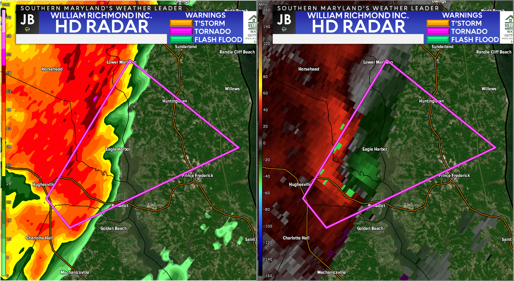
The storm reached its peak intensity as it passed over Route 231 in Benedict at 8:36PM. The radar image above was able to capture this moment. On the left-hand side of your screen, you can see the typical radar reflectivity image.
On the right-hand side of the screen, you can see the radar’s velocity image; measuring the direction and strength of the storm’s winds. The red colors on the right-hand image represent winds going away from the radar site whereas the green colors represent winds going towards the radar. The tight couplet of red and green colors is representative of tight rotation, showing just how strong the storm was.
The storm continued to track northeastward into far southern Prince George’s County, through southern Eagle Harbor, before crossing the Patuxent River into Huntingtown. The storm then began to lose its tight rotation, while remaining rather strong. The tornado lifted back up into the clouds as the storm approached Route 4 in Huntingtown, before reaching the shore of the Bay in Willows, MD shortly before 9PM.
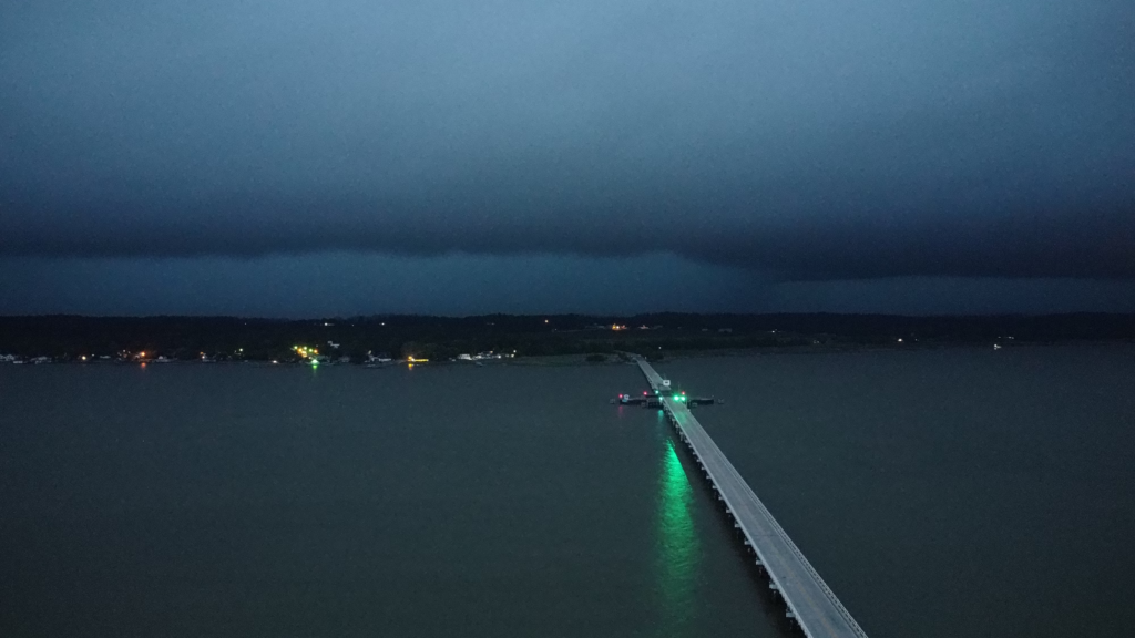
Adam Daugherty was able to capture the moment that this storm approached the Route 231 Bridge, connecting Charles and Calvert Counties. The image was captured in Hallowing Point, MD looking into the storm, towards Benedict, MD. While you cannot see the tornado verbatim in this image, you can see the wall cloud associated with this storm and the intense rain shaft in the center portion of the image.
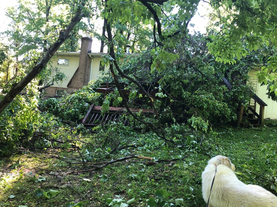
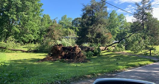
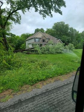
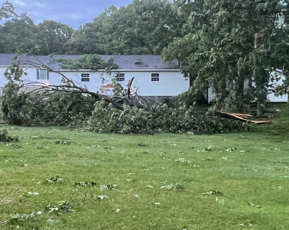
Above are some of the many images of storm damage that have come in across our social media feeds over the last 36-48 hours. All of the owners of these images did give written permission for JB Weather to showcase them. In all of these images, you can see just how destructive this storm was as it moved through.
We will likely get additional information on this storm as the National Weather Service continues to investigate what happened. Stay tuned for potential additional updates and information.
Friday’s severe weather shows why it is important to take every severe weather warning seriously! JB Weather was the only local source that was LIVE with you throughout this event as these dangerous storms moved through Southern Maryland. When severe weather strikes, JB Weather is working to keep you and your family ahead of the storm!
You can always access my forecasts and updates here on the website, on Facebook, on Twitter, on Instagram, and on YouTube. JB Weather is Southern Maryland’s Weather Leader!
-JB
John Bordash
View More PostsJB Weather forecaster John Bordash is working around the clock to provide Southern Maryland, and neighboring communities, with accurate and reliable weather information.

1 thought on “BREAKING: Tornado Confirmed from Friday Night’s Storms”
Comments are closed.
Thanks JB!!! We were safe in the basement because of you!