Brought to you by Batteries Plus
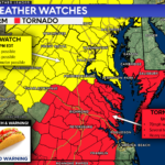
The Storm Prediction Center has upgraded our area to an Enhanced Risk (Level 3 of 5) of seeing strong to severe thunderstorms this evening. The Enhanced Risk of storms is highlighted in the orange zone on the map above. Much of the rest of the region remains under an Elevated Risk (Level 2 of 5).
This comes as a cold front looks to move through our region this evening. This cold front will likely develop a broken line of thunderstorms as it moves eastward. The main threats this evening are damaging winds up to 50-65mph, small hail, and even the threat of a spin-up tornado.
Our Chesapeake’s Bounty Futurecast does a great job of showing the potential threat in our area.
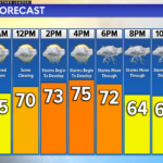
Initially, we may see scattered storm cells begin to develop out ahead of the main cold front between 1-5pm. These cells could produce enhanced damaging winds, some small hail, and could even lead to a quick-spinup tornado. I am not expecting a tornado outbreak, though. If we fail to see enough warming this afternoon, thus limiting the amount of storm energy in the atmosphere, then this round may not be as impactful.
Then, we will see a line of storms develop along the cold front, and push through after sunset. Within this line, there are likely to be a couple of severe storms. The main threat with this potential line will be enhanced damaging winds up to 60mph and localized ponding on roadways.
It will be important to say weather aware and to be prepared for weather conditions that could change quickly! We may see severe weather alerts get issued throughout the afternoon and evening, so you will want to have a way to get those alerts (JB Weather is a great choice)!
Say with JB Weather for the latest information. I will be in the weather center all afternoon and evening tracking the latest developments on today’s active weather. You can always access my forecasts and updates here on the website, on Facebook, on Twitter, on Instagram, and on YouTube. JB Weather is Southern Maryland’s Weather Leader!
-JB

Brought to you by Batteries Plus at our new location on West Dares Beach Road in Prince Frederick. Your locally owned one-stop-shop for everyday & hard-to-find batteries, lighting, phone repair, auto key fobs and much more. Stop by today, or give us a call at (443) 968-2056. Or visit our second location on St. Andrews Church Road in California.
1 thought on “BREAKING: Upgrade to an Enhanced Risk of Severe Storms”
Comments are closed.


[…] [ March 31, 2022 ] BREAKING: Upgrade to an Enhanced Risk of Severe Storms Breaking Weather […]