Brought to you by Chesapeake Orthodontics
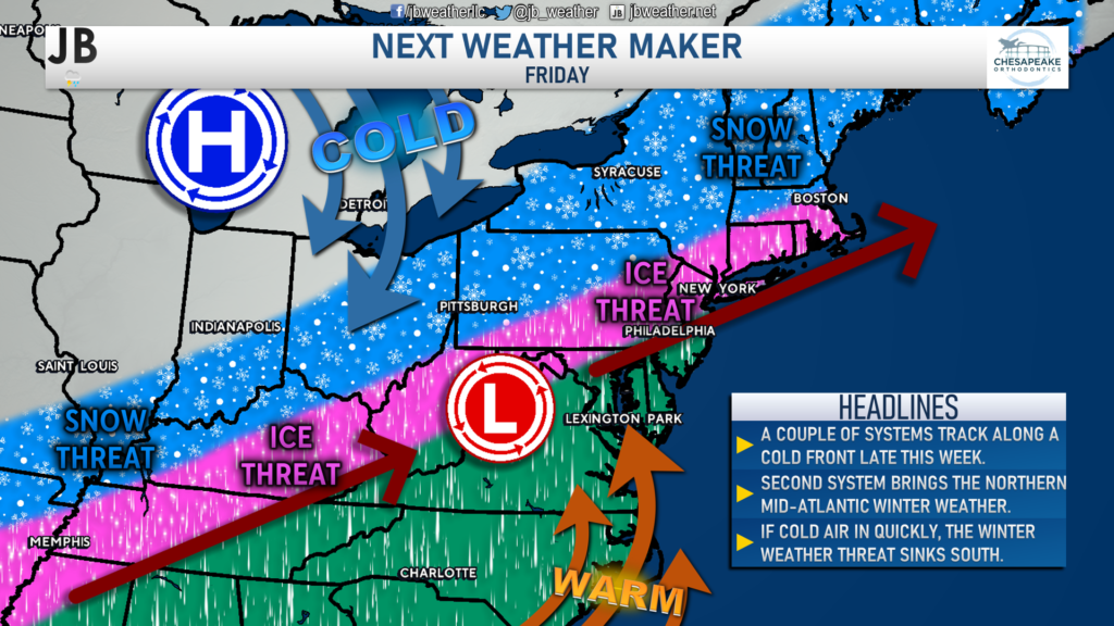
A complex weather setup is likely to emerge as we head into later this week. We will have an extended cold front that will be moving southeastward across the county. As the front slowly moves to the southeast, multiple waves of low pressure are likely to form and ride along the moving front. This may sound complicated, and that’s because it is. Simply put, as the front sags south, these low-pressure systems will move northward along the front. This will lay the groundwork for these systems to move from southwest to northeast– from Texas to New England.
The first system, depicted in the tweet above, is likely to bring just rain to the region on Thursday. Warm air will surge out ahead of the cold front, allowing many areas to get into the 50s and low 60s by Thursday night. This part of the forecast is relatively certain.
As the cold front sags further south, we will see cold air begin to move further south towards our region. At the same time, a secondary area of low pressure will form. This new system will move northeastward, like the prior system. However, the front will be much further south by this time, with cold air on its way south as well. This will set the stage for Friday’s potential mess. How far south can the cold front and arctic air get as the developing system passes by?

Our modeling is not in agreement on this. Shown below is the North American Mesoscale (NAM) model. This model shows the initial round of rain on Thursday with warming temps. However, it also depicts a much slower arrival of cold air as the system passes by on Friday. As a result, much of our region remains as pure rain through the event, with only areas north of the Mason Dixon having the threat of going over to a period of ice on Friday.
The American (GFS) Model shows a different story, presented below. While the GFS starts our region off with a period of rain on Thursday, it has the cold front and associated arctic blast moving much further south as the secondary system passes by. The GFS shows much of our region going over to an icy mix of sleet and freezing rain throughout the day on Friday as the system passes by. This would be a high-impact scenario and could lead to high ice impacts, especially northwest of DC.
Which model is correct? Only time will tell. What has been consistent is that the GFS Model has been the lone model showing such an extensive ice impact. With that said, though, I will not completely discount it. How quickly can the cold air move into the region? That is the critical question. I would give a scenario as the GFS Model shows a 40% chance of happening.
Right now, we seem pretty likely to see the most significant snow risk confined to the Great Lakes region. Thursday’s rain is the most likely to transition to ice and potentially snow along the Appalachian Mountains. Locally, areas northwest of DC and Annapolis have the highest chance to see the rain end as a brief period of sleet and freezing rain. Southeast of DC, I expect much of this event to be rain, but there is the chance that this may briefly end as sleet.

We will learn a lot more over the next day about this potential setup and its impacts here in the Mid-Atlantic. I do not expect a widespread ice storm across our region as things stand now. The zones with the highest chances of seeing ice are north of the Mason Dixon line. Any interests in those regions should take note! Locally, we will need to see how far south and how quickly the cold air can move in on Friday. More answers to come!
It will be important to stay with JB Weather for the latest information on this potential event and its impacts here in Southern Maryland. You can always access my forecasts and updates here on the website, on Facebook, on Twitter, and on YouTube. JB Weather is Southern Maryland’s Weather Leader, and I am working around the clock to keep you ahead of the storm!
-JB

Dr. Thomas Hao and Dr. Dylan Schneider offer comprehensive orthodontic services for all ages. Schedule your free consultation today. Visit www.SOMDBraces.com today for more information!
1 thought on “Could Friday’s Rain End as a Wintry Mix?”
Comments are closed.


[…] [ February 1, 2022 ] Could Friday’s Rain End as a Wintry Mix? Top Stories […]