Brought to you by All in One Tag & Title
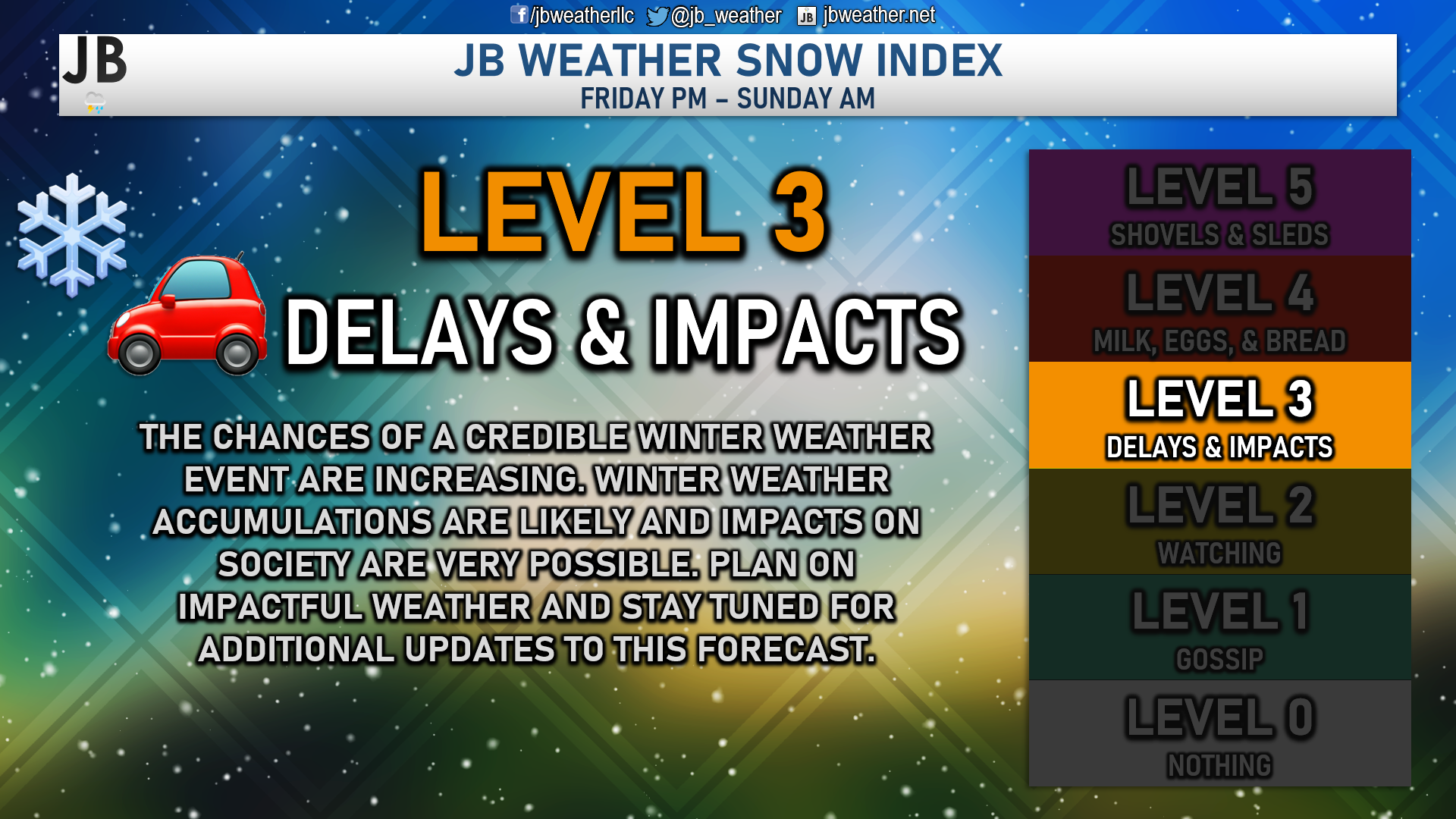
Another week, another storm threat! The active month of January keeps on rolling with yet another chance of snow for late this week. Over the last few days, there has been plenty of talk online and on-air about the existing storm potential. While there is credibility to this threat, I do not believe that this will be some sort of blockbuster event with widespread double-digit snows. With that said, though, I am raising the snow index to a Level 3. I think it has become pretty likely that we will indeed see accumulating snow, which could cause delays and impacts across the region. However, I do not think that you need to raid the stores in preparation of its arrival.
The Setup
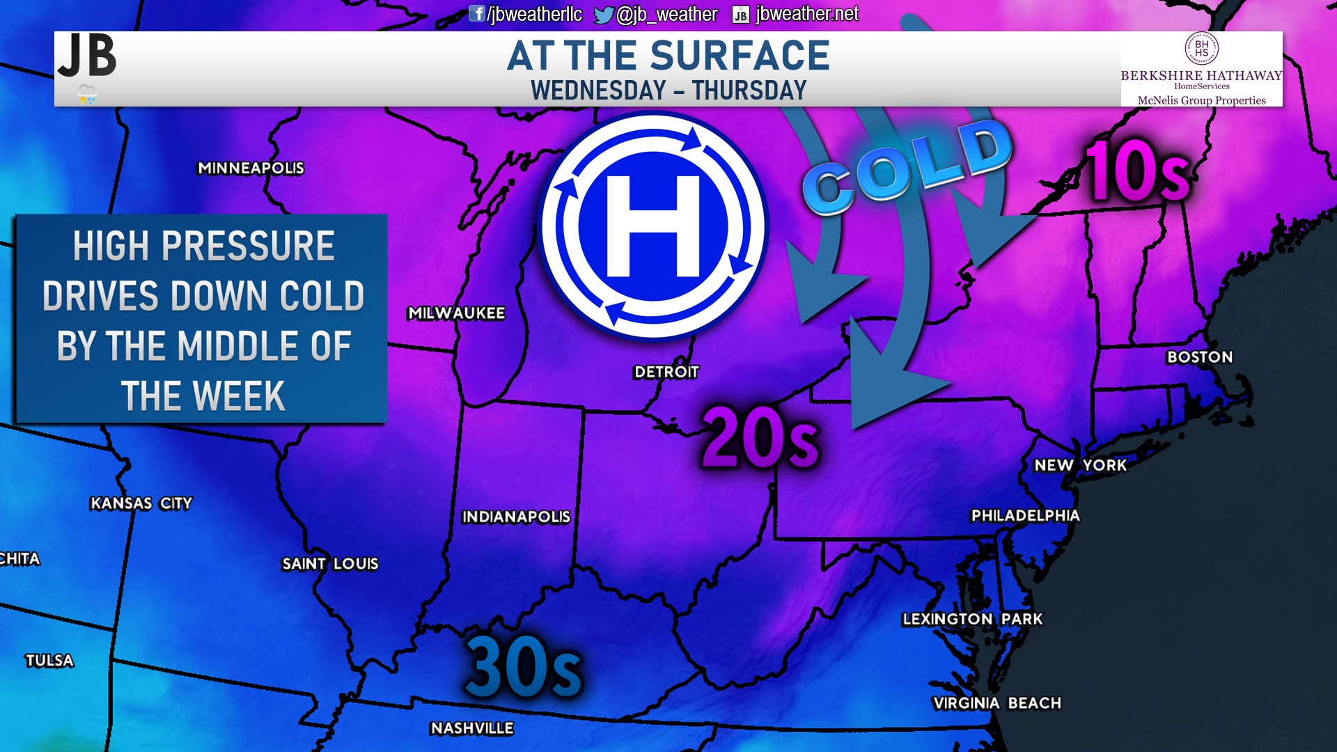
Wednesday has been a cold day across the Mid-Atlantic, with highs hanging out around freezing. This is because an area of high pressure has been established to our north. High pressure in that location drives down cold air from southern Canada across the East Coast. This cold air will stick around for Thursday before moderating some on Friday. However, we will see a reinforcing shot of cold air settle in late Friday, laying the groundwork for some wintry mischief this weekend.
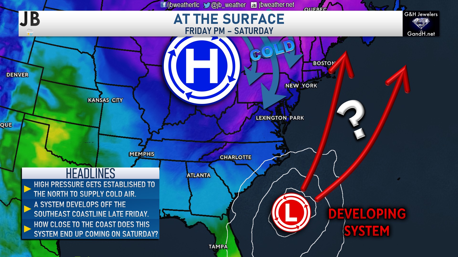
As high pressure gets established across our region, we will see a system develop off the southeast coastline. This system will move northward over the weekend, with plenty of moisture. This initial part of the forecast seems pretty locked in. The question is, where does the storm end up tracking as it moves northward? Does it come closer to the coast or out to sea? Let’s break these scenarios down a little bit more.
Scenario 1: Coastal Track
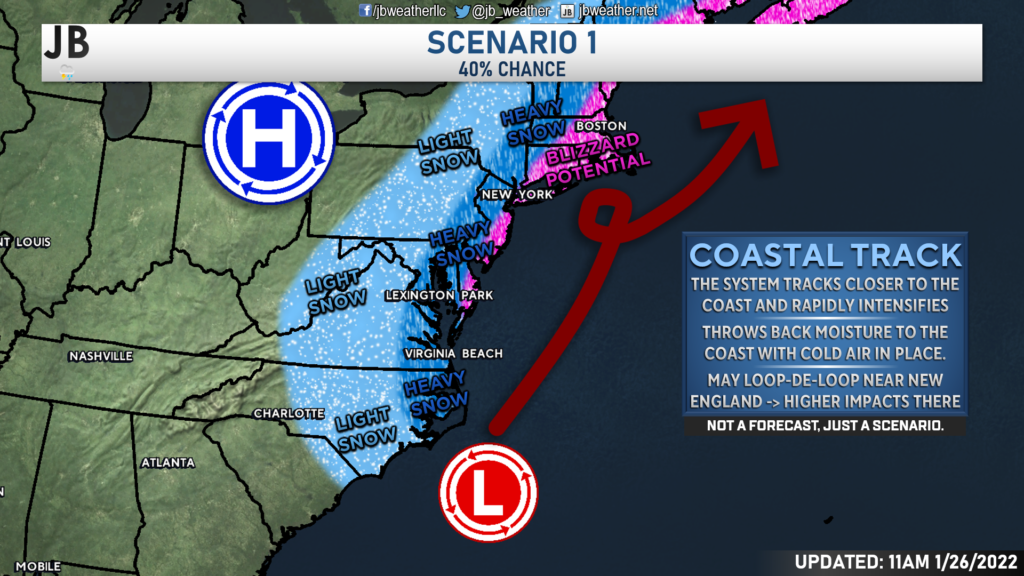
This is type of scenario would feature the developing area of low pressure to track closer to the coast. As it does so, it would likely merge with upper atmospheric energy, which would help also slow the storm down. The end result would be heavy snow along and east of I-95, with the potential for blizzard conditions along the Atlantic coastline. Thanks to the loop-de-loop, New England would likely see prolonged blizzard conditions with this type of solution. This would also place high snow totals in Southern Maryland. This is a solution that many models have shown over the last few days and would result in a truly historic storm. With that said, we have begun to see our models move away from this solution, which is not surprising to me. This weekend, the upper atmospheric pattern is not super favorable for a 2010-esk blizzard. However, we are still 2-3 days out, and a lot can change. I will not totally write this off yet. I peg the chances of this solution verifying at around 40%.
Scenario 2: Eastern Track
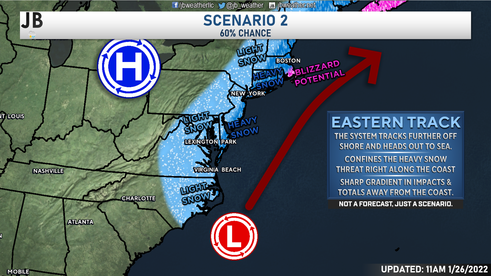
The other scenario on the table is a more eastward-based track. While the storm would still be decently strong as it moves northward, it would have little interaction with additional atmospheric energy. The end result is that the storm does not get pulled in as close to the coast and is allowed to slide out to sea at a decent clip. While this solution would still bring snow to many regions, it would only focus the heaviest snow right along the coast and in New England. This is the solution that our American model has been showing for a couple of days now. I think this is closer to the actual result. I give this scenario the edge against Scenario 1 and place its chances at 60%.
Timing
Our Futurecast model is shown above and simulates how the storm may unfold. I will say that our model has been more the camp of Scenario 1 than Scenario 2. That’s to say, our model favors a more westerly track, closer to the coast. As a result, this model has more snow in our region. While I think the snow output is likely overdone, I do like the general timing that it has.
We will likely see snow break out across the region Friday evening, probably after sunset. Initially, this snow will not be too heavy. It will be light and manageable. However, as the system strengthens, we will see the snow pick up in intensity, especially for southern and eastern zones. Snow is likely to fall throughout the night and into Saturday morning. The heaviest snow will likely fall along the Delmarva and into New Jersey as the system pulls northward. We will see the snow wrap up from west to east by midday Saturday. The snow will hang on the longest at the coast.
Accumulation Maps
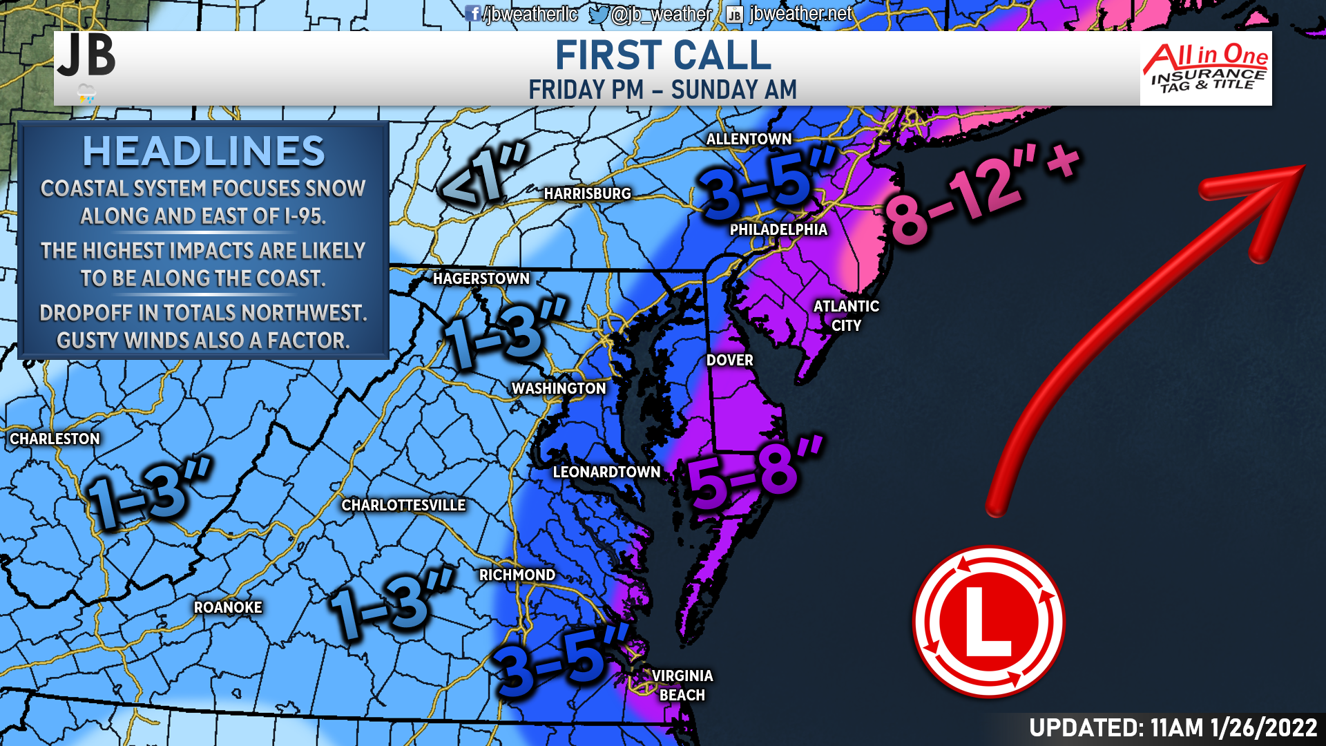
With all of that in mind, it looks very likely that the coast will see the heaviest snow, areas west of I-95 will see the lightest snow, and we will be sandwiched in between. As things stand right now, I think the Delmarva could very well pick up 5-8″ of snow throughout the event. More snow will be found along the Jersey shore, and into New England, where 8-12″+ is likely to fall. I think 3-5″ is doable along the Bay, with 1-3″ west of I-95. The snow west of I-95 is likely to fall mainly on Friday night, whereas the snow on the coast is likely to fall on Saturday. Southern MD is in the middle, so I would expect most of our snow to fall during the first half of Saturday.
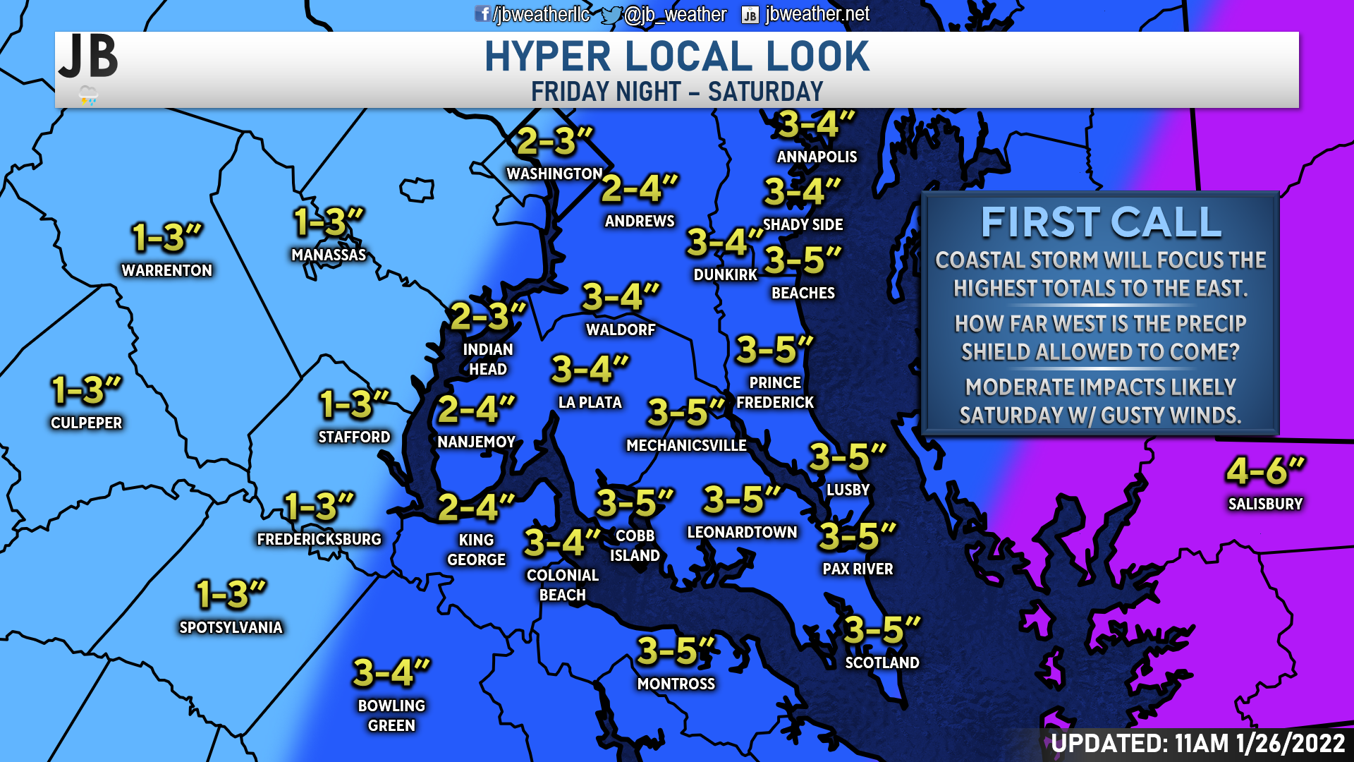
Locally, I think the highest totals will be found along the Bay and in Southern St. Mary’s County. I think these are the spots that could see upwards of 5″ of snow. The further west you head, the lower the snow totals. Zones west of Route 301 are likely to only see 2-4″, with areas west of I-95 seeing only 1-3″. The significant factor for our local forecast will be how far west the precipitation shield with the storm can come. The further west it comes, the higher the totals. Conversely, the further east it goes, the lower our totals will be.
What Do the Models Say?

How about the models?! Well, the models are simply just tools we have in our toolbox as forecasters. Models do not make the forecast, but they give us a good starting point. Our models generally fall in line with my projections. Right now, the NAM model seems to be the outlier on the upper extremity. While I would not discount those totals completely, I think they are unlikely to happen. The National Weather Service (NWS) currently sits in the upper end of my ranges with their forecast totals. The GFS (American) and European models fall nicely inside my ranges.
It is important to note that these totals have come down from what they were yesterday, and we may see that continue to happen. It remains to be seen just how much more they will correct downward or if they are settling into a consistent zone.
Impacts
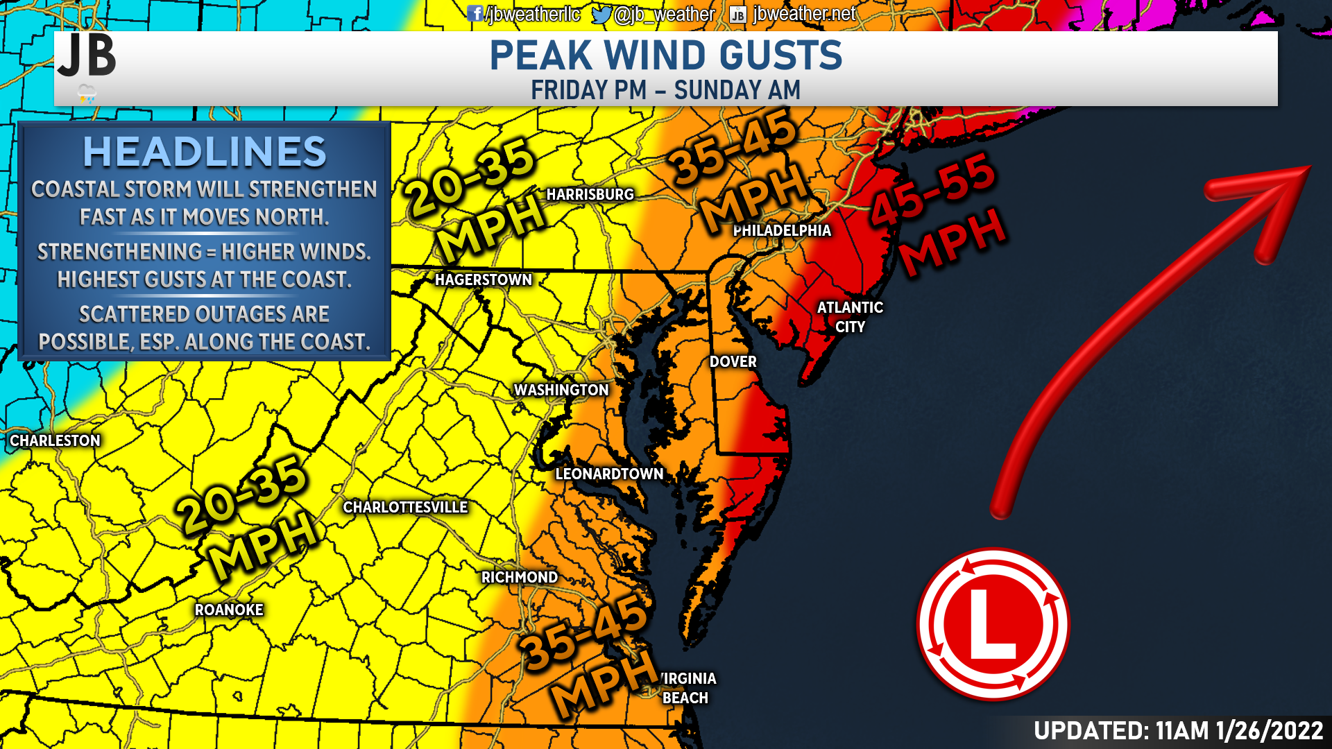
In addition to the snow, the winds will also be a factor at play with this forecast. As systems strengthen, they pull in more energy that is around them. We experience that here at the surface as increased wind. The highest wind gusts will be found along the coastline, closest to the storm system. 45-55mph gusts look possible from Ocean City northward into New England. East of I-95, we could see 35-45 wind gusts at times. These wind gusts could cause coastal flooding, especially at the Atlantic beaches, and scattered power outages.

I think that this will end up being a moderately impactful storm here in Southern Maryland. We will likely see moderate snowfall accumulation east of I-95, which will likely lead to snow-covered roadways by Saturday morning. The highest impacts will be felt on Delmarva, where snow totals are likely to be the highest, with wind gusts up to 55mph being possible.
Storm FAQs
How confident are you in your forecast? I have medium confidence in this forecast. I feel pretty certain that we will see snow Friday night into Saturday. The question is, just how far west is the axis of heavier snow able to come. The uncertainties with that question is what brings down my confidence level for this system.
Where will the heaviest snow fall? The highest totals look likely to be concentrated on Delmarva, and point north along the Atlantic coastline. The lighter snow totals will be found west of I-95, which leaves our region sandwiched in between these two zones.
When will the snow start? Current guidance shows that the snow may begin after sunset on Friday.
When will the heaviest snow fall? Probably during the morning hours between roughly 2-4am and 10-11am on Saturday.
When will the snow end? The storm should begin to pull away from the region by midday Saturday, which will allow the snow to shut of from west to east by early-to-mid afternoon.
How much snow will I get at my house? Check out the accumulation map. Generally, I’m expecting 3-5″ for most of the region, with lower totals west of I-95, and greater totals east of the Bay.
Could more or less snow fall than currently forecast? Absolutely. In order for even more snow to happen, we would need to see the storm track further west, along the coast. This would allow those heavy snow bands to develop right over Southern MD. On the other hand, if the storm takes a slight jog to the east, many areas may struggle to see much. In light of these plausible scenarios, here’s my assessment of snowfall probabilities:
10% chance: <1″
25% chance: 1-3″
40% chance: 3-5″
25% chance: 5-8″+
As you can see, I think there is a greater than normal chance of either a bust (less snow than expected) or a boom (more snow than expected). However, I think that there is only a 1 in 10 chance that we see no accumulating snow.
Will the snow stick? It is likely that we see snow accumulation on both grassy surfaces and on roadways. The recent cold shots have helped to bring down ground and road temperatures. I think the snow will have no problem sticking as soon as it falls, which is what will lead to area-wide issues.
Any chance of a wintry mix of freezing rain or sleet? I am not worried about an icy mix with this storm. Temperatures look to stay at, or below, freezing throughout this event.
Summary
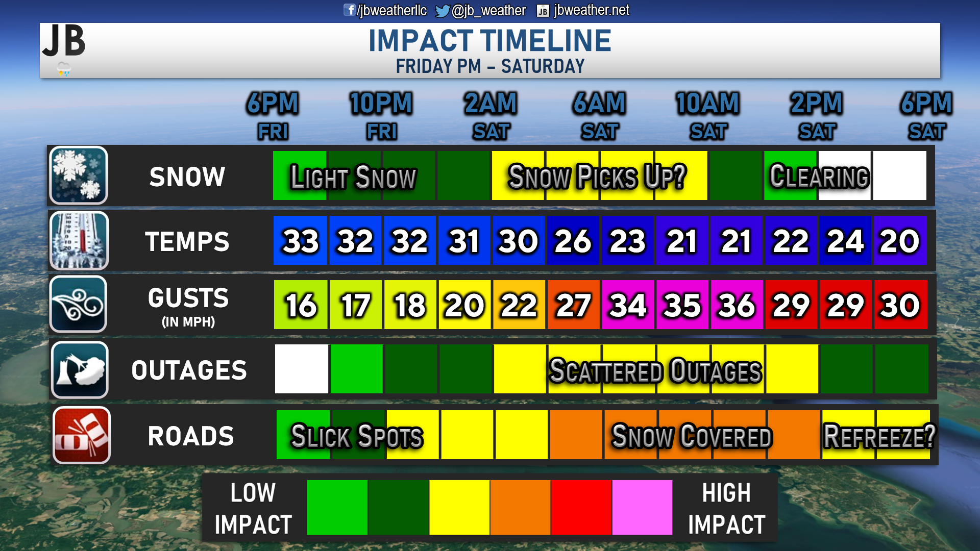
All-in-all, it does look likely that we will snow later this week, late Friday into Saturday. However, I am not expecting this to be a blizzard. However, a decent 3-5″ of snow looks likely across the region. We are likely to see moderate impacts as we head into Saturday. Roads are likely to be snow-covered, and some scattered power outages are yet again possible thanks to gusty winds. I would expect regionwide travel delays for Saturday as a result. These issues will be heightened across the Atlantic coastline. We will need to monitor how far west the system comes and how strong it gets. Both will play significant roles in determining how much snow does indeed fall and what the impacts could look like.
It will be important to stay with JB Weather for the latest information on this winter storm and its impacts here in Southern Maryland. You can always access my forecasts and updates here on the website, on Facebook, on Twitter, and on YouTube. JB Weather is Southern Maryland’s Weather Leader, and I am working around the clock to keep you ahead of the storm!
-JB

At All In One Tag & Title, we make quick work of MVA Tag & Title Services! We are located in Owings, MD on the corner of Chaneyville Rd. Give us a call at 301-327-5081 or stop by, no appointment needed! Mention you saw us on JB Weather and get $5.00 off tag & title services. Check out www.allinonellc.net today!
John Bordash
View More PostsJB Weather forecaster John Bordash is working around the clock to provide Southern Maryland, and neighboring communities, with accurate and reliable weather information.
1 thought on “First Call: Snow & Wind Likely Friday PM into Saturday”
Comments are closed.
[…] [ January 26, 2022 ] First Call: Snow & Wind Likely Friday PM into Saturday Top Stories … […]