Brought to you by Bill Oosterink, Realtor
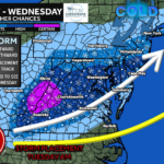
An active week of weather has brought an onslaught of back-to-back storms to the Mid-Atlantic. Yet another system looks likely for Tuesday. However, this system will look to bring snow to much of the Mid-Atlantic, with a potential bullseye on the DC Metro area.
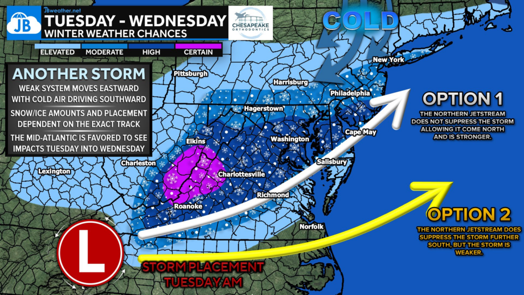
A system will move eastward on Tuesday as cold air pushes southward. This will help to create a band of snow along the northern side of the track. How strong that cold air is, though, will be a big determiner of where exactly the heaviest snow and rain/snow line set up.
We are likely to see snow overspread the region by late-morning on Tuesday. Our Cedar Point Federal Credit Union Futureview model shows that bands of moderate to heavy snow may develop by the evening hours. You can also see that mixing line, represented in pink, creeping close by.
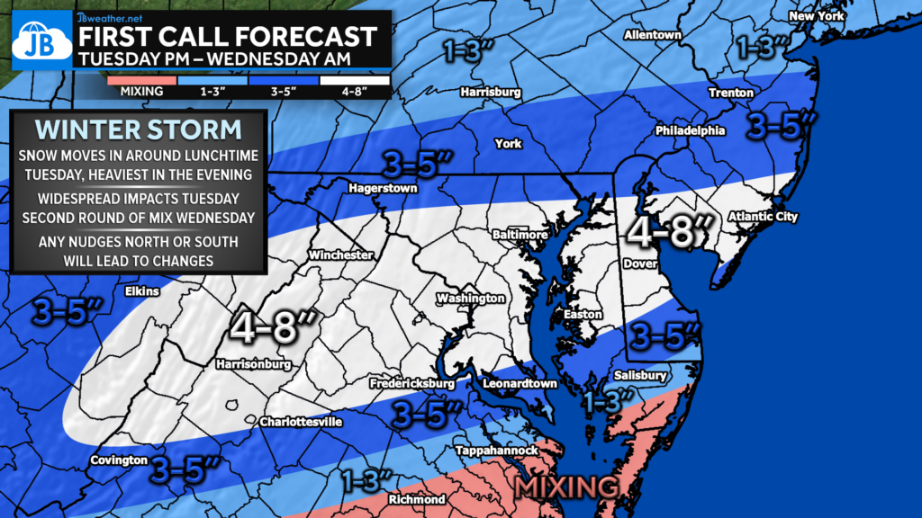
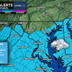
It looks like the axis of the heaviest snow will set up from the Appalachian Mountains, through the DC area, and out towards the coast. This region is likely to see 4-8″ of snow, which could be heavy at times.
3-5″ of snow seems like on either side of that. Lighter precip rates will keep totals down north of Baltimore and potential mixing issues will keep totals down south of Prince Frederick and Fredericksburg.
Totals drop off to 1-3″ on the outer edges as mixing will be a bigger issue to the south of Lexington Park and very light precip rates north of Harrisburg.

Locally, we are likely to see the highest totals north of Prince Frederick and Waldorf. Many locations in the white-shaded region will see nearly half a foot of snow. Totals drop off south of the Benedict Bridge as mixing becomes an issue. But still, periods of moderate snow are likely to put down decent accumulations.
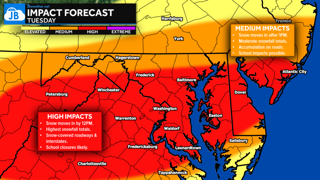
Widespread, high impacts are likely Tuesday afternoon and evening. Even though the snow starts around midday, I would expect widespread closures for the red-shaded region. Accumulations on roadways will be problematic there. Moderate impacts outside of that region. Impacts may be slower to develop there and may not be as high thanks to slightly lower totals. But road accumulations are still likely, and school impacts are likely. I will have a full School Odds report out tomorrow.
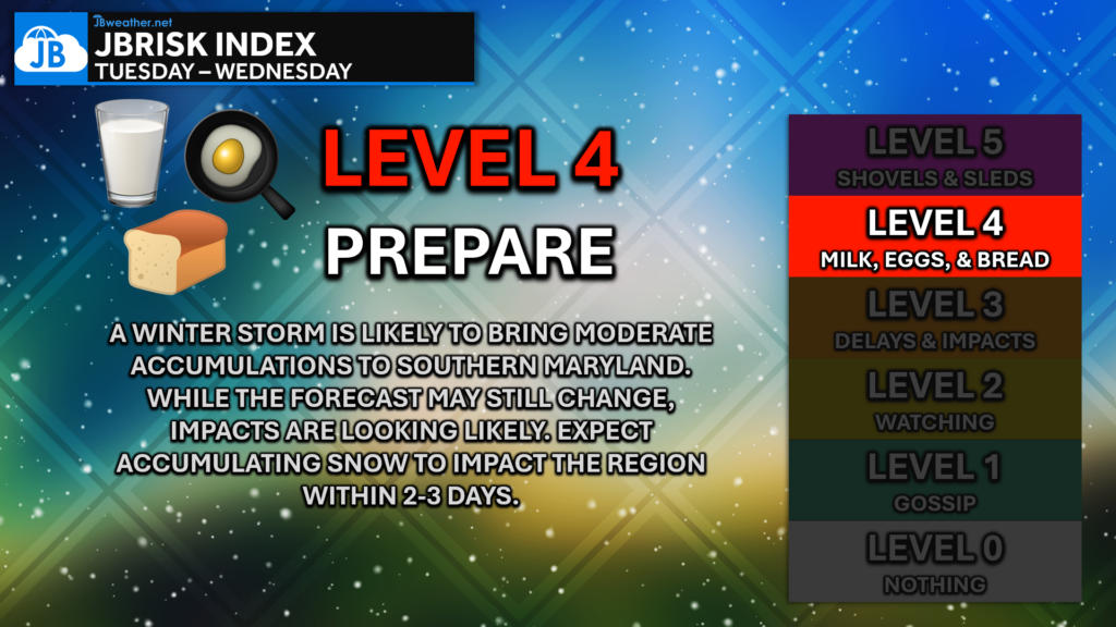
All in all, this seems like a sizeable winter storm for the region on Tuesday. Expect snow to move in by midday Tuesday and linger into Wednesday. Up to 4-8″ of snow is likely for many, causing widespread high impacts. We will need to be on guard for any subtle shifts in the track as that could impact totals.
Stay with JB Weather for the latest information on impacts here in Southern Maryland and across the Mid-Atlantic. You can always access my forecasts and updates here on the website, on Facebook, on Twitter, on Instagram, and on YouTube. JB Weather is the Mid-Atlantic’s Weather Leader, and I am working around the clock to keep you ahead of any storm!
Buying. Selling. Investing. Ready when you’re ready! Check out www.somdDreamHome.com today!
John Bordash
View More PostsJB Weather forecaster John Bordash is working around the clock to provide Southern Maryland, and neighboring communities, with accurate and reliable weather information.
2 thoughts on “First Call: Winter Storm To Bring Impactful Snow Tuesday”
Comments are closed.
[…] First Call: Winter Storm To Bring Impactful Snow Tuesday […]
Thanks, Bill!