Brought to you by Sonder Studios
Incoming moisture Wednesday night will set up the threat of an icing event going into Thursday morning. A transition to rain will happen quickly southeast of I-95, but sleet and freezing rain will hold on into the AM commute on Thursday northwest of I-95 with moderate impacts.
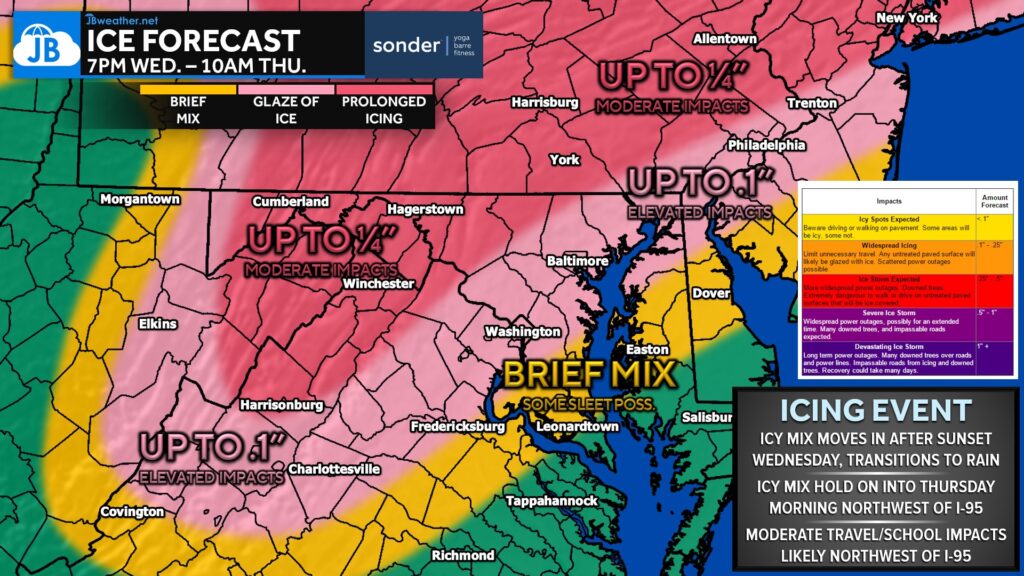
Impacts will be on the low-end across Southern MD as any early snow/sleet around sunset Wednesday should go to a cold rain. But that cold air will be stubborn to kick out of the western/northern valleys. Widespread icing is likely to linger until mid-morning Thursday along I-81.
Stay with JB Weather for the latest information on impacts here in Southern Maryland and across the Mid-Atlantic. You can always access my forecasts and updates here on the website, on Facebook, on Twitter, on Instagram, and on YouTube. JB Weather is the Mid-Atlantic’s Weather Leader, and I am working around the clock to keep you ahead of any storm!

SONDER℠ Yoga studio. Barre studio. Fitness Studio. Classes, events & education for being well. Sonder is a mindful community, and you are invited. 5+ years in Calvert County, MD. We are grateful for your trust. Check out sonderstudios.us!
John Bordash
View More PostsJB Weather forecaster John Bordash is working around the clock to provide Southern Maryland, and neighboring communities, with accurate and reliable weather information.