Brought to you by Calvert Title Company
After tonight’s chance of storms moves through, all eyes will turn to tomorrow. Monday will offer our region its first substernal and legitimate chance of severe weather this season. As it is always the caveat, storms are not guaranteed tomorrow. Let’s break this threat down some!
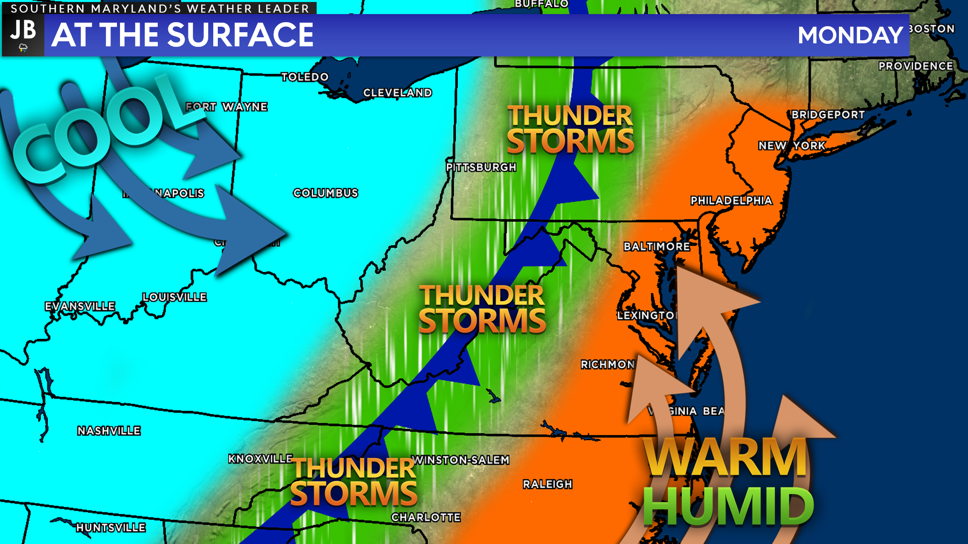
We will have a southerly flow in place tomorrow. This will allow warm and humid conditions to surge northward into our region. At the same time, there will be a strong cold front to our west that will be coming eastward throughout the day. As the colder air runs into the warm and humid air, several thunderstorms are likely to develop. This will be the main driver for tomorrow’s storm chances.
Like this morning, tomorrow morning is likely to feature some fog, cloud cover, and a couple of areas of drizzle. We should see these conditions give way to sunny, warm, and humid conditions by lunchtime. The afternoon and evening severe threat will be dependent on how quickly we break into the sunshine and warm up. The longer that takes, the lower the severe weather threat will be. The reverse is true if we clear things out quickly.
Those that have lived around here long enough know that this “high bust” (no severe storms) and “high boom” (multiple severe storms) setup is very typical. It will all come down to the amount of sunshine we see and where the best atmospheric forcing exists.
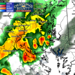
Our Chesapeake’s Bounty Futurecast shows the threat of clouds and drizzle throughout the morning hours before clearing after lunchtime. The window of clearing skies in the early afternoon would allow temperatures to warm into the 80s and the humidity to build. The warm temps and humidity would allow ample amounts of storm energy to develop, laying the groundwork for storms.
Storms are likely to first develop out west of I-81 during the early afternoon hours as the cold front works eastward. These storms should strengthen as they move over the mountains as the best atmospheric conditions for storms looks to be along I-95 and the coastal plain.
We are likely to initially see 1 or 2 storms develop somewhere in the Mid-Atlantic out ahead of the main line by 3/4pm. If these cells do develop, they would have the potential to rotate and potentially produce a brief tornado. Then, the main line is likely to work through the region during the evening hours, bringing heavy rain and gusty winds.
The exact placement of the storms, especially the pre-frontal ones, are likely to occur where the greatest atmospheric forcing sets up. It is hard to narrow down where that would be this far out. Think of this as a camera. Initially, the picture is blurry, and you can only point out generalities. As we get closer to the event, the pictures become more clear.
Right now, all I can say with any confidence is that this is likely to happen somewhere in the Mid-Atlantic. I can’t say for sure if it is focused on Southern MD, southern PA, or New York. However, we should begin to form a better idea of what to expect as we through tomorrow.
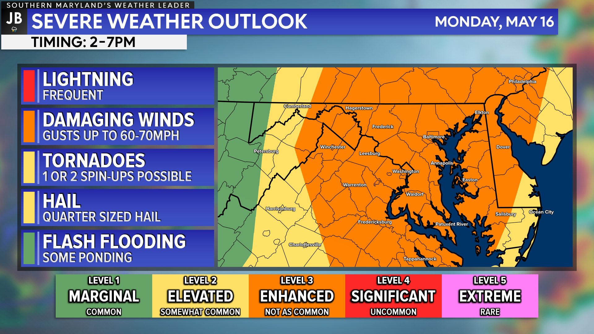
With all of that in mind, the Storm Prediction Center has placed our entire region under a Level 3 “Enhanced Risk” of severe weather for the first time this year. This threat is mainly focused east of the Blue Ridge. The timing tomorrow looks to be from 2-7pm.
The main threat with tomorrow’s storms will be damaging winds and hail. However, there will be a tornado threat in any of the pre-frontal storms that try to fire up. Again, it is hard to say where those will form exactly, so everyone will need to stay aware of that. Flooding and ponding will become an issue if we see a couple of rounds of storms move through.
It is possible that we see the worst of the weather develop to our north, to our south, or right over us. Therefore, it will be important to stay weather aware and to be prepared for weather conditions that could change quickly! We may see severe weather alerts get issued throughout the afternoon and evening tomorrow, so you will want to have a way to get those alerts (JB Weather is a great choice)! I will have an update to this forecast tomorrow morning and again around lunchtime tomorrow.
Keep in mind that severe weather forecasting is far from a guarantee of anything. The goal of these forecasts is to alert you to the potential of storms, not a promise of storms.
Stay with JB Weather for the latest information on impacts here in Southern Maryland. You can always access my forecasts and updates here on the website, on Facebook, on Twitter, on Instagram, and on YouTube. JB Weather is Southern Maryland’s Weather Leader, and I am working around the clock to keep you ahead of the storm!
-JB
Brought to you by Calvert Title Company. Calvert Title Company is guiding you HOME one closing at a time! Check out https://calverttitle.com/ today!
John Bordash
View More PostsJB Weather forecaster John Bordash is working around the clock to provide Southern Maryland, and neighboring communities, with accurate and reliable weather information.