Brought to you by Berkshire Hathaway HomeServices PenFed Realty
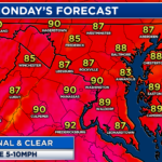
Today is turning out to be one of the better Independence Days we’ve seen around here over the last few years. Many spots are sitting under mostly clear skies with seasonally warm temps! This will change tomorrow, though, as storms will look to potentially push through tomorrow afternoon and evening.
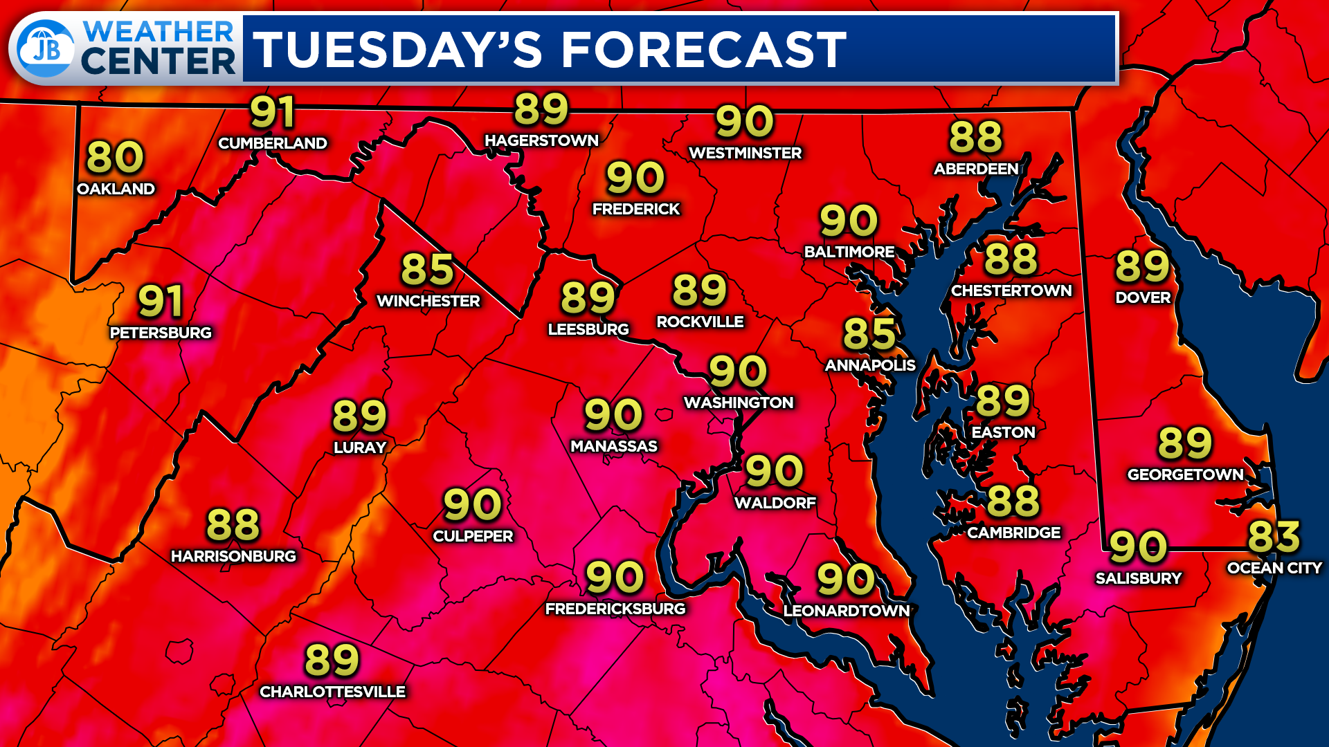
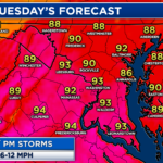
Like today, tomorrow will look to be a warm day across the region with temperatures looking to max out in the upper 80s to lower 90s. The key difference is that the humidity will be making a big-time come back tomorrow.
This hot and humid combination will allow for atmospheric storm energy to form across the region. This will lay the ground for potential thunderstorm development as a frontal boundary passes overhead.
Our Chesapeake’s Bounty Futurecast seems to have a good handle on the potential setup for tomorrow. A warm front will be crossing the region tomorrow, allowing for an even warmer middle part of the week. As the warm front passes through, it will act as a trigger to fire storms across the region. This is likely to happen during the afternoon hours, tomorrow.
With enough sunshine in the morning, along with heat and humidity, we will have ample storm energy present across the region. We should start to see storms fire back to our west around lunchtime. These storms may try to form into a broken line as they race eastward as we approach the evening rush hour.
Futurecast suggests that these storms could get pretty strong as they move into a very favorable environment for storm development. These storms will look to push through between 2/3pm and 8/9pm, and clear out of the region after sunset.
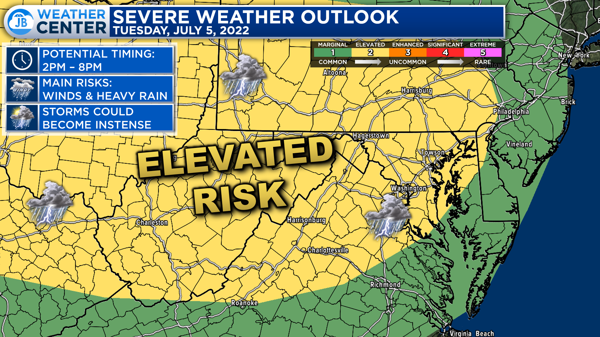
In anticipation of this storm threat, the Storm Prediction Center has already placed much of the region under a Level 2 “Elevated Risk” of severe weather for tomorrow. This indicates the increased chance of seeing several strong to severe thunderstorms.
It would not surprise me to see the Elevated Risk expand out towards the coast, and for a Level 3 “Enhanced Risk” to be introduced for some parts of the Mid-Atlantic. However, it is also possible that we see increased cloud cover tomorrow morning which bring down the severe threat. This will be a very fluid forecast, and this will change as learn more about the setup.
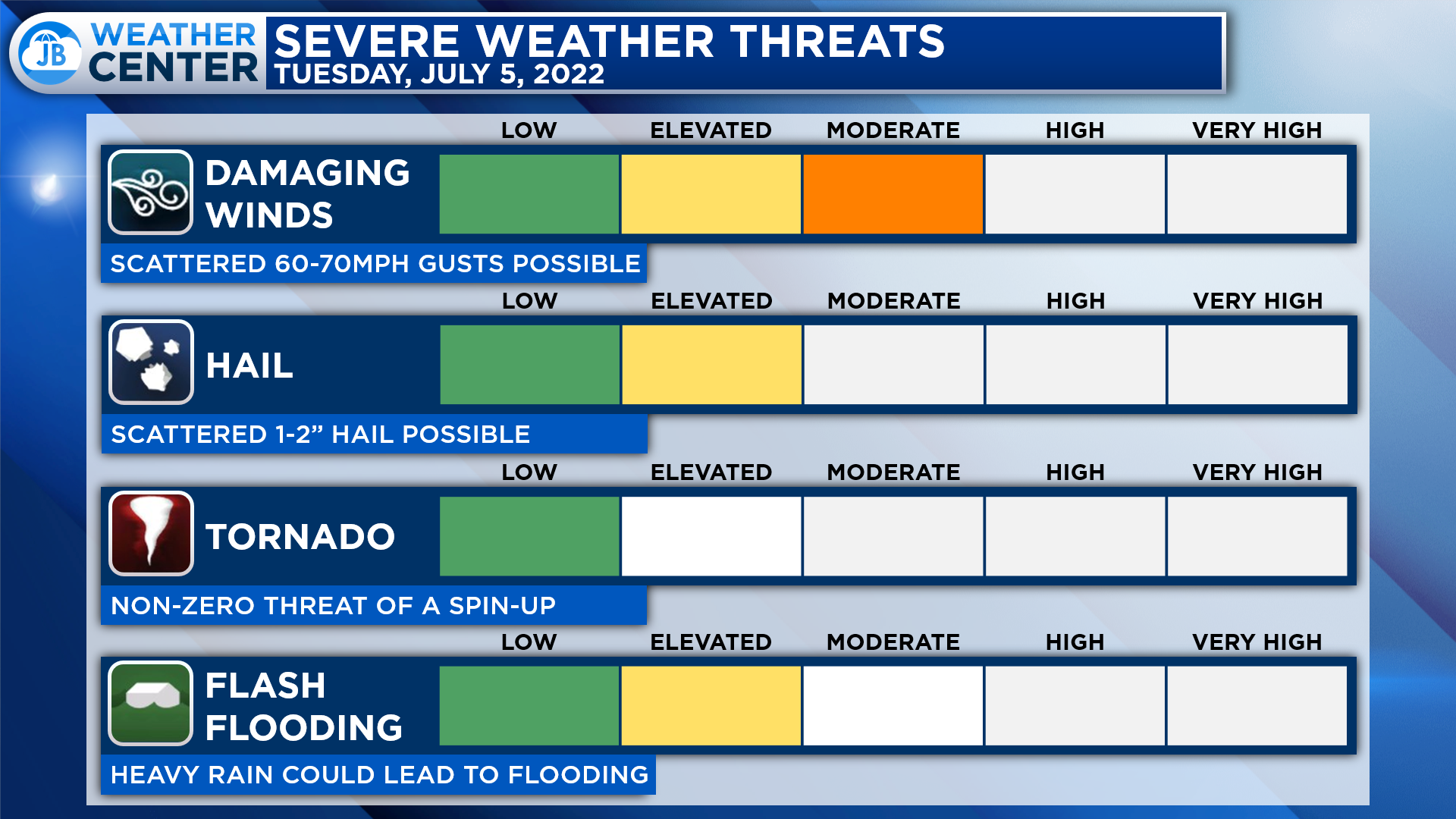
The main risk with tomorrow’s storms would be damaging wind gusts and intense heavy rain with lightning as these storms push through. There is also a risk of 1-2″ sized hail and a non-zero tornado threat that I cannot ignore.
While I am not expecting a tornado outbreak tomorrow, there will be an added element of twisting and turning with the winds tomorrow that could allow for a weak spin-up to form. With that said, I am not expecting widespread tornadoes. I am much more concerned about the risk of 60-70mph winds with potential storms.
Remember that severe weather forecasting is far from a guarantee of anything. The goal of these forecasts is to alert you to the potential of storms, not a promise of storms.
If you have outdoor plans tomorrow afternoon, I would definitely suggest staying weather aware and having a Plan B ready to go in case these storms do form. It is not a 100% guarantee that these storms will form, as is always the case, but if they do they could bring high impacts. Be ready to act as weather conditions could change suddenly and quickly.
Stay with JB Weather for the latest information on Southern Maryland weather. You can always access my forecasts and updates here on the website, on Facebook, on Twitter, on Instagram, and on YouTube.
-JB

Real Estate now! Not sure where to start? View our Southern Maryland inventory of homes, land, farms and commercial properties on penfedrealty.com. Engage with our planning tools to determine your next real estate lifestyle decision, choose your realtor as a trusted advisor. Experience the difference with service and support from real estate’s forever brand!
John Bordash
View More PostsJB Weather forecaster John Bordash is working around the clock to provide Southern Maryland, and neighboring communities, with accurate and reliable weather information.