Brought to you by All in One Tag & Title
This week has gotten off to quite the summer-like feel. This is thanks to a “heat dome” of high pressure that has formed over the center portion of the country. This high pressure will not only be responsible for the heat and humidity over the next couple of days, but also for increased rain chances. The first chance of rain comes late tonight into tomorrow morning.
Tonight, a weak frontal boundary will set up along the Bay, separating the warm and humid conditions inland from the cool and stable conditions at the coast. A decaying storm complex will move out of Pennsylvania and ride southward along this boundary. This may set off the potential for scattered showers and storms as it moves through.
Our Chesapeake’s Bounty Futurecast shows that we may being to see showers and storms develop between midnight and sunrise tomorrow. The exact placement of these potential showers and storms is still in question, so do not take Futurecast verbatim. There is uncertainty around how much storm energy will be present, and how far east the boundary will get overnight. Both of these will determine our outcome.

Rain chances tomorrow morning will increase the further east you head. Over a 50% chance of rain is forecast for the Eastern Shore, where the frontal boundary is the most certain to have crossed. Areas that are along and east of that boundary will have the highest storm chances. We will need to monitor how far west this can get.
Locally, rain chances are the highest for our Bayside communities. Rain chances will extend as far back as I-95, but they will be reduced. The boundary in question is likely to set up somewhere between the Bay and the Atlantic coast.
The severe risk tomorrow morning will not be overly high tomorrow morning, but it also will not be zero. The main concern with any showers or storms that fire would be locally heavy rain. Rain totals will vary greatly tomorrow morning, with some areas getting nothing and others getting as much as an inch or two. This could cause localized flooding. Damaging winds could also be a concern, but that risk is far lower. All other severe risks appear unlikely.
The timeframe we could see showers move through would be between 3am and 8am. Some impact is possible on the morning commute, especially in the areas that get in on heavy rain, so stay aware. Any showers that do develop would be moving eastward, allowing for clearing to take place during the mid-morning hours.
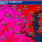
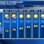
The midday clearing will allow temperatures to soar into the lower 90s with increased humidity. This will look to set the stage for another chance of showers and storms in the afternoon and evening.
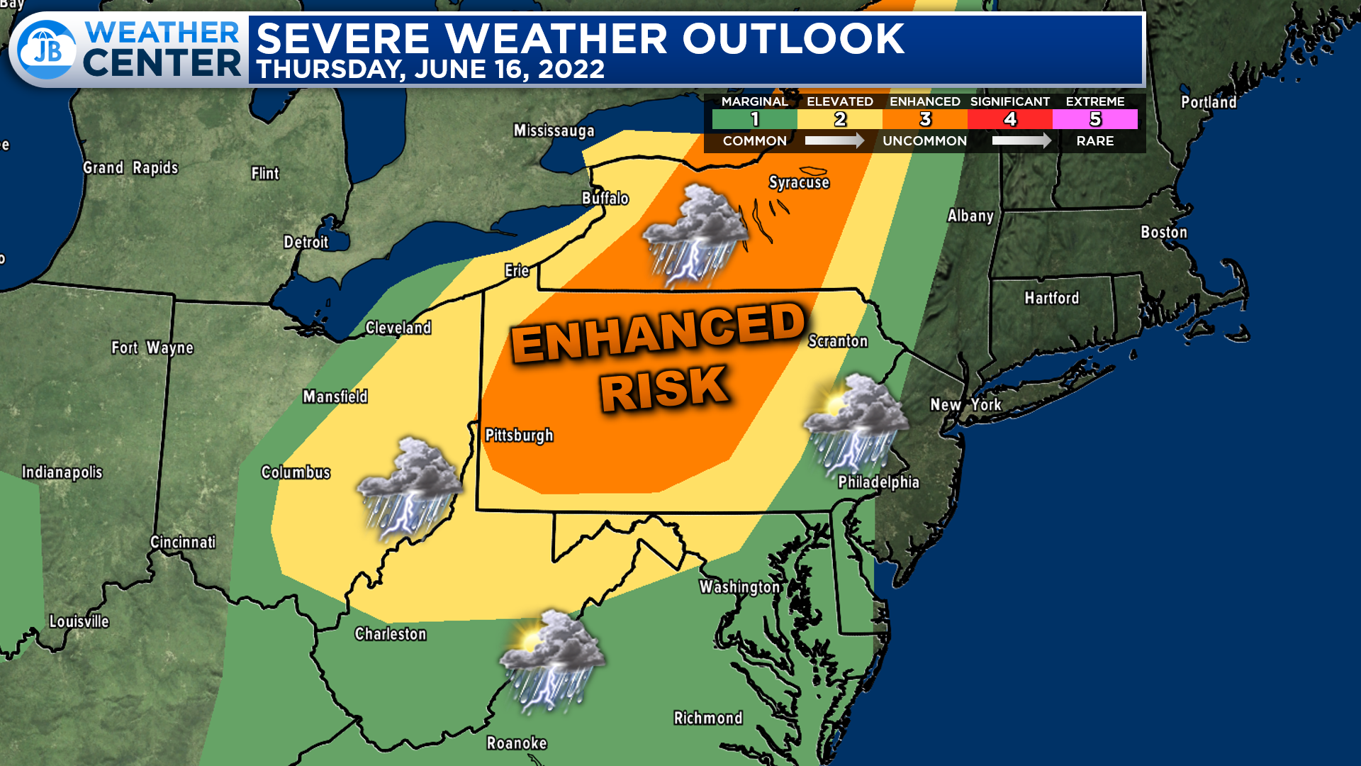
The forecast for Thursday afternoon and evening gets complicated. Generally speaking, the highest severe weather chances will exist across the interior of the Northeast. This is where the Storm Prediction Center has outlined an “Enhanced Risk” of severe weather. This threat tappers off to the southeast as you approach our region. But that is due to increased uncertainty in our local forecast.
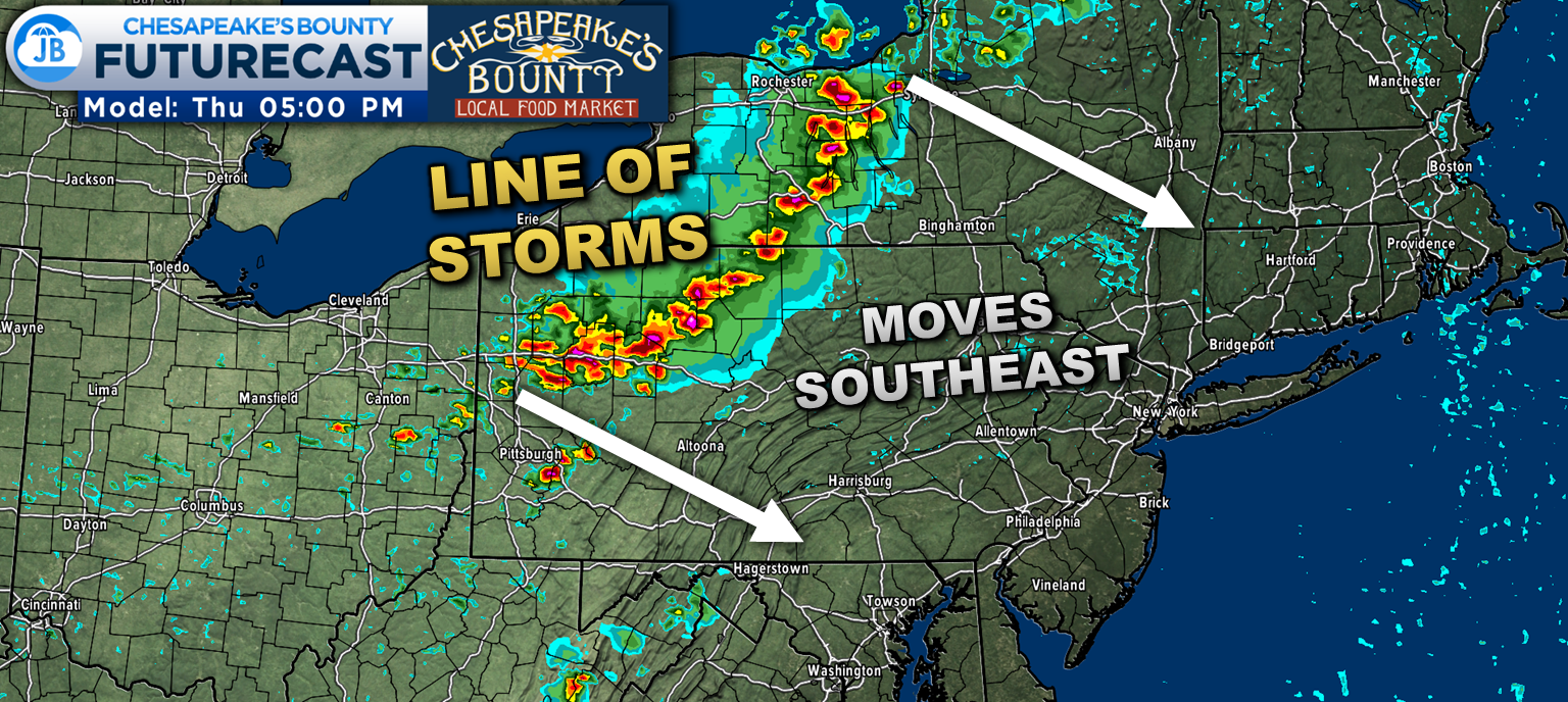
A line of storms will develop in southern Canada and then work through the western New York and western Pennsylvania tomorrow afternoon. This line will work southeastward throughout the afternoon. There is a question on how south and east this line makes it before running out of steam. Locally, the areas that may be impacted by this will be along the MD/PA state line tomorrow evening, around sunset.
This main line of storms is not likely to make it as far south as Southern Maryland. This is because it would not reach our area until well after sunset. That would mean that we would have lost peaking heating and the majority of our storm energy. But it will be something to watch. The areas that do feel the impact from this line could see 60mph winds, hail, flooding rain, and even an isolated tornado.
However, a different area of storminess may impact our region.
A wave of atmospheric energy may develop out ahead of that main line. This weak wave of energy will pass through northern Virginia and Maryland tomorrow afternoon. With enough lift and storm energy, we could see a small line of storms develop along it. 1 or 2 of these storms could be strong to severe and bring locally heavy rain and gusty winds. The timeframe for this to move through would be between 4/5pm and 7/8pm. With that said, it is unclear whether this small line could indeed develop. This is the nature of summertime storm chances.
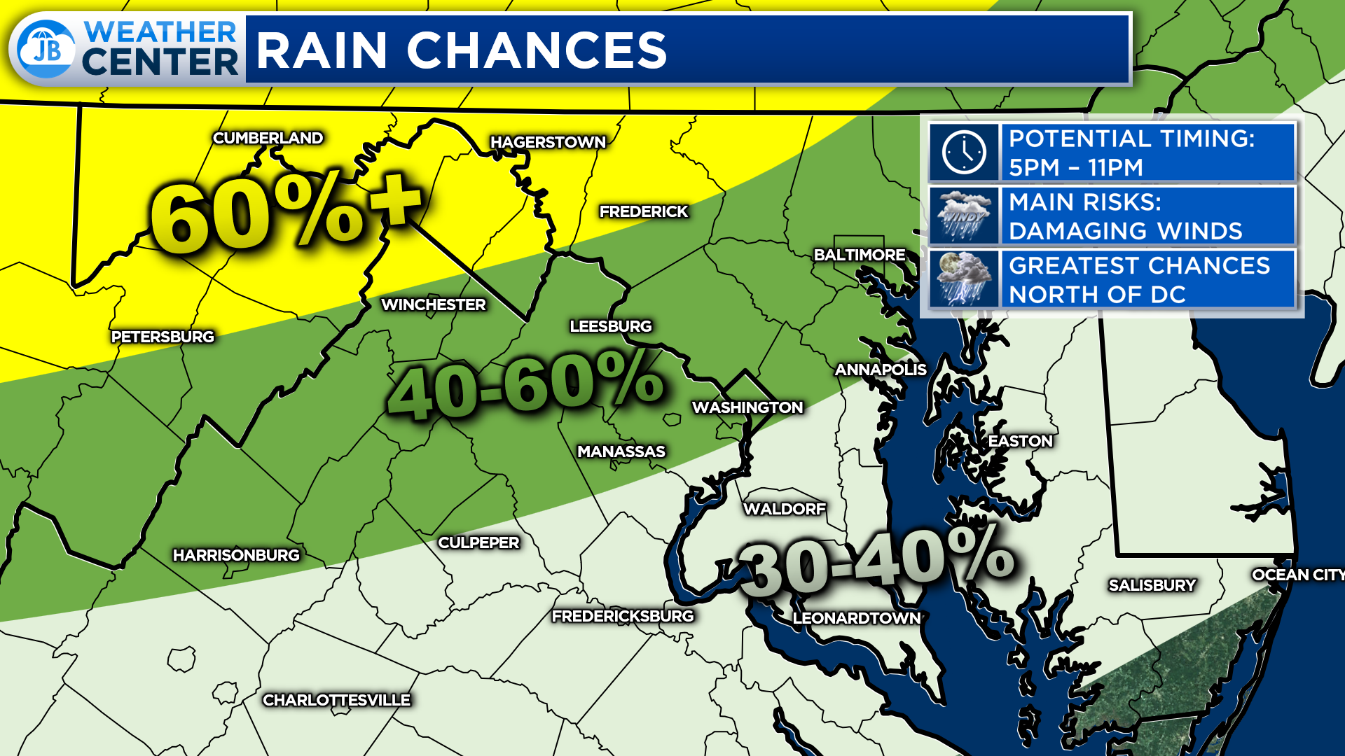
All in all tomorrow afternoon’s forecast does, indeed, look complicated. It seems most likely that the highest chances of rain tomorrow afternoon and evening will be northwest of DC, where that primary line of thunderstorms may move through.
Locally, we will need to see if a smaller area of storminess can fire up if we can see enough midday clearing and heating. If we do, we could also see some isolated to scattered severe storms in the afternoon. There is greater uncertainty on whether that will happen or not, hence the lower rain chances southeast of DC. If that main line does make it to our region, we would not see that rain until 10 or 11pm. But, again, the chances of that are low.
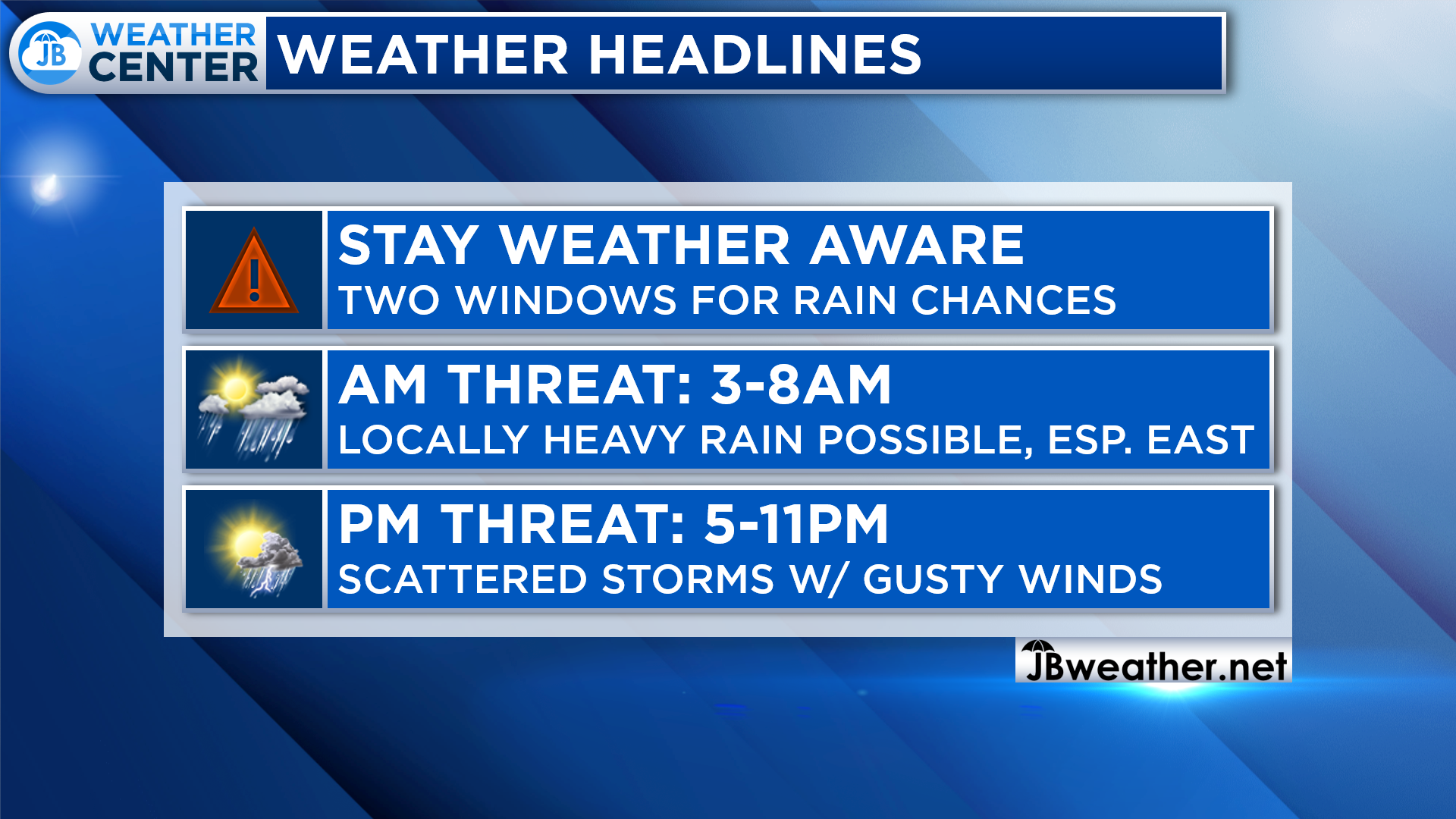
In summary, tomorrow will offer our region a couple of different chances of showers and storms. You may be greeted tomorrow morning with locally heavy rain as a decaying storm complex moves through. The highest chances of rain will be along the Bay and the Eastern Shore. This could cause some localized ponding on roadways between 3-8am.
Then, after some midday clearing, another chance of showers and storms exists between 5-11pm as weak areas of atmospheric energy pass overhead. Enough midday heating could allow for scattered storms to develop and push through gusty winds. A shower or storm is possible after sunset with a dying line of showers and storms that will push through the northeast, as well.
You will want to stay weather aware throughout the day tomorrow. Be aware that conditions could change quickly tomorrow, and conditions may vary from location to location.
Stay with JB Weather for the latest information on Southern Maryland weather. You can always access my forecasts and updates here on the website, on Facebook, on Twitter, on Instagram, and on YouTube.
-JB

At All In One Tag & Title, we make quick work of MVA Tag & Title Services! We are located in Owings, MD on the corner of Chaneyville Rd. Give us a call at 301-327-5081 or stop by, no appointment needed! Mention you saw us on JB Weather and get $5.00 off tag & title services. Check out www.allinonellc.net today!
John Bordash
View More PostsJB Weather forecaster John Bordash is working around the clock to provide Southern Maryland, and neighboring communities, with accurate and reliable weather information.