Brought to you by the Southern Maryland Spring Fling
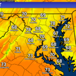
A system moving out of the central Plains will look to bring moderate to high impacts to our region, just in time for Mother’s Day. Heavy rain, some storms, gusty winds, minor tidal flooding, and cool temperatures are all likely through Sunday as our system stalls off the Mid-Atlantic coastline this weekend.
Our Futurecast model is doing a pretty good job of depicting the threat. We will likely see rain showers begin to move into the region early tomorrow morning. Rain will look to pick up in coverage and intensity throughout the day and continue into Saturday.
While it will not rain everywhere all of the time on Saturday, much of the day will be spent with rain– some of it heavy at times. This will be due to the system stalling just off the coastline, throwing moisture back towards the coast. We see this happen in the Winter, which can lead to big-time snow. In this case, this will lead to a lot of rain. The rain will then look to break up some and gradually move out on Sunday.
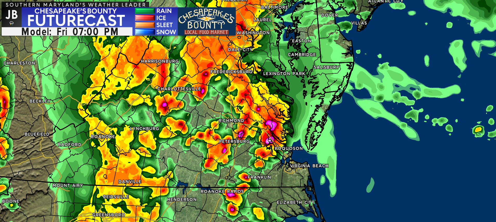
Our high-resolution modeling shows that tomorrow afternoon will likely offer the best chance to see thunderstorms across the region as our long-duration event gets started. By the afternoon and evening, we may see embedded thunderstorms develop. This is will be allowed to happen where warmer air is able to get established, causing the atmosphere to become unstable.
Futurecast suggests that this is the most likely to happen across Virginia and North Carolina. Southern MD is likely to be on the edge of this warmer air, which means that while we won’t have the highest storm chance tomorrow evening, the threat will not be zero. The main risk with any storms would, of course, be heavy rain and gusty winds. 1 or 2 storms to our south may even try to rotate, especially south of Richmond, VA.
We may see a brief break in the rain Saturday morning as the coastal system gets established. By lunchtime, we should see rain redevelop across the region. Our Futurecast shows that bands of moderate to heavy rain may get established east of I-95, and continue into the evening and overnight hours.
We may see a brief break in the rain Saturday morning as the coastal system gets established. By lunchtime, we should see rain redevelop across the region. Our Futurecast shows that bands of moderate to heavy rain may get established east of I-95, and continue into the evening and overnight hours.
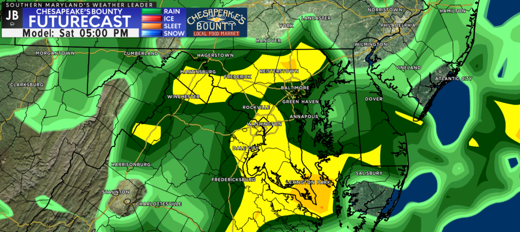
As mentioned earlier, we will see the rain gradually come to an end on Sunday. Sunday morning will offer the highest chances of rain, but scattered showers will remain possible throughout the day. It is not until after midnight that rain chances being to zero-out.
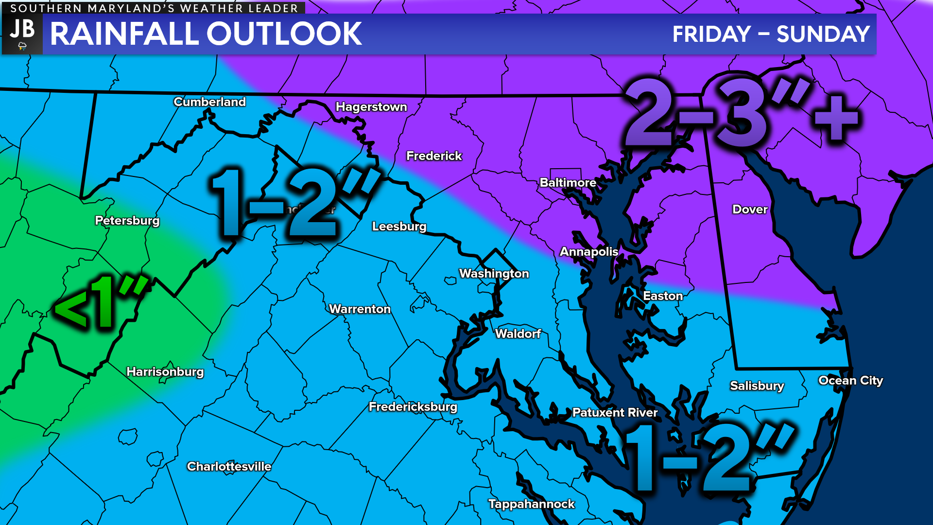
All-in-all, I think it is likely that many spots see between 1-2″ of rain between Friday and Sunday. Actual rainfall totals may vary widely due to the exact locations in which the heaviest rains set up. Some spots may see more than 2″ and some may see less than an inch. With that said though, most should fall in that 1-2″ range.
Amounts up to 2″ are possible across southern PA and northern MD. It is important to note, again, that the zone of heaviest rains may shift either north or south depending on the exact axis of the heaviest rain.
The main takeaway here is:

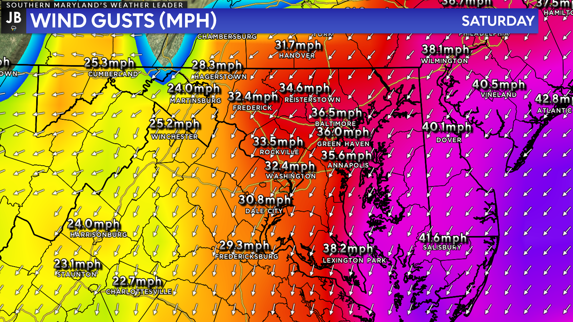
In addition to the rain this weekend, we will also have to contend with gusty winds. The winds are likely to have the highest impacts on Saturday as the coastal system develops. By its very nature, this coastal system will produce onshore, easterly winds. These winds, especially Saturday afternoon and evening, could gust upwards of 30-45mph.
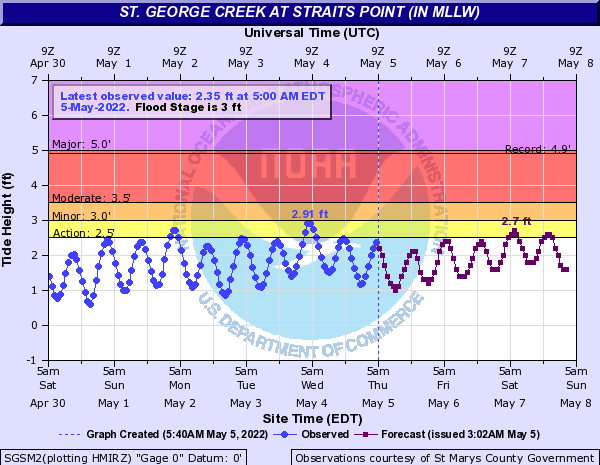
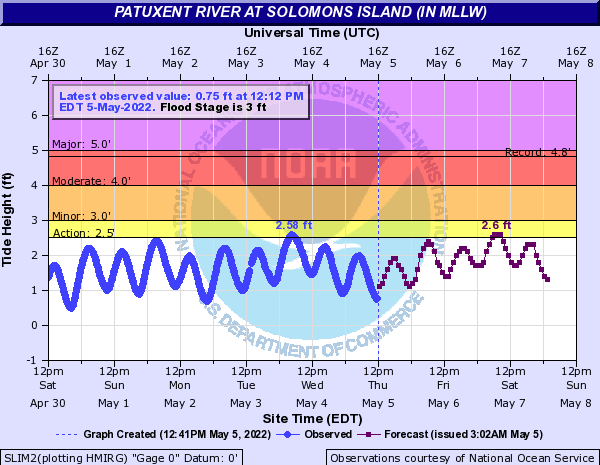
The onshore direction of the wind will lead to some minor coastal flooding. Shown below are the water level forecasts for Solomons Island and St. George Island. Both forecasts show that the water levels in those spots may approach 2-3 feet Saturday evening, which does lead to some minor tidal flooding along the immediate coastlines.
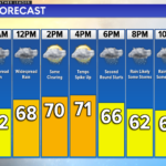
All-in-all, Mother’s Day Weekend is not looking to be a great one in the weather department. Expect periods of heavy rain, gusty winds, some tidal flooding, and temperatures that are stuck in the lower 60s Friday-Sunday.
Unfortunately, it looks like we may stay unsettled with additional rain chances throughout next week. However, we will deal with one event at a time.
Stay with JB Weather for the latest information on Southern Maryland weather. You can always access my forecasts and updates here on the website, on Facebook, on Twitter, on Instagram, and on YouTube.
-JB

Brought to you by the Southern Maryland Spring Fling. Join us for the Southern Maryland Spring Fling May 21st & 22nd at the Charles County Fairgrounds! This event is sure to please with something for everyone to enjoy! Some of the highlights for this year’s event include: Live entertainment daily (featuring the Fabulous Hubcaps, The Flipin Eyelids,The Ashley Denay Band, and the Strictly Business Band), over 80 Artisans/ Crafters/ Vendors bringing handmade and unique items to market, a Fireworks Spectacular (Saturday night), Local Breweries and Wineries, Pig Races, Chainsaw Carving Shows, Strolling Entertainers, over 20 of the regions best food vendors providing delicious festival eats and treats; even the kids will be taken care of with a Kid Zone that’s packed with fun to include a petting zoo, pony rides, moonbounces, foam party, face painting, balloon artists, magic shows, games, activities and more! Visit www.DoodleShows.com for discounted tickets today!
John Bordash
View More PostsJB Weather forecaster John Bordash is working around the clock to provide Southern Maryland, and neighboring communities, with accurate and reliable weather information.