Brought to you by Berkshire Hathaway HomeServices PenFed Realty
We have some light rain showers and increased cloud cover around this afternoon. I do not expect any downpours– just some passing sprinkles that should last for 15-20 minutes. We will see cloud cover continue to increase overnight. Temps will cool off quickly as well.
An upper-level low will move through the region tomorrow, which will help to push the Jetstream well to our south and keep the warmth out west. This Jetstream dip will help to usher in a blast of some rather cold air. For those that have grown accustomed to the warmer temps the last few weeks, this will be quite a shock to your system!

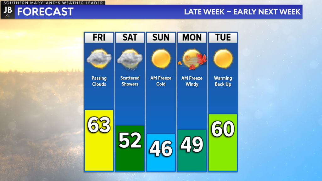
This time of the year our average high is up near 60°. The resurgence of below-average temperatures will mean that temperatures are likely to only be the 40s with overnight lows in the 20s! By Sunday and Monday, it will feel much more like February. Thankfully, warmer temps will try to return by mid-week.

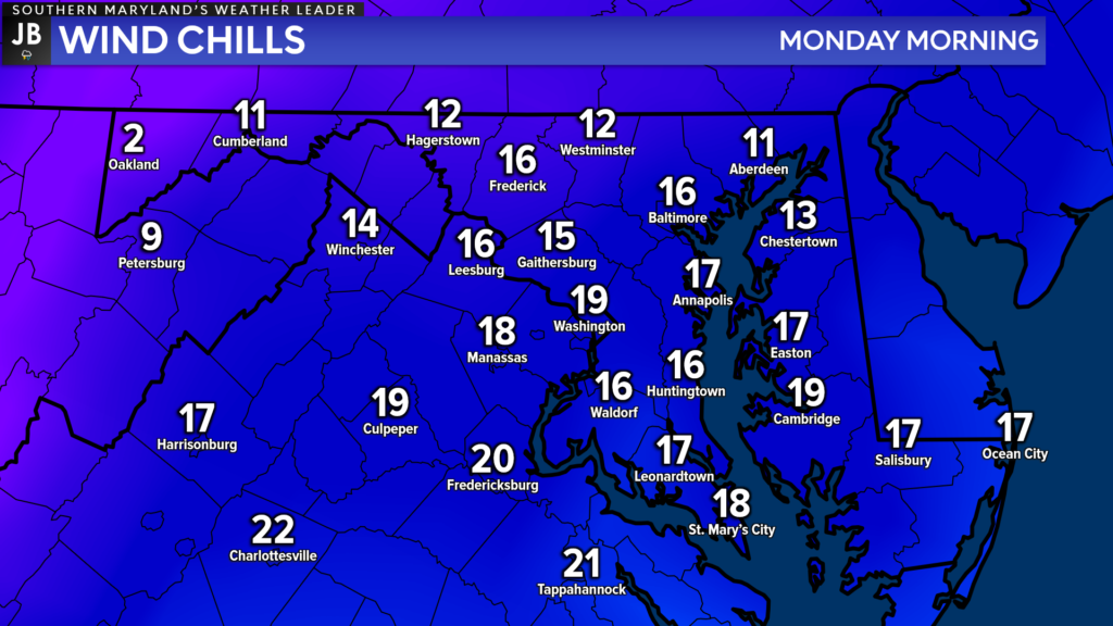
Sunday will likely be the coldest day during this stretch, with temperatures only maxing out in the middle 40s. This will set the stage for a very cold night Sunday night. Overnight lows are likely to get down into the middle-to-upper 20s. We will have a stark northwest wind around too, which will make it feel like many spots are in the teens by the time you’re waking up Monday morning!
An upper-level area of low pressure will be what is responsible for this blast of cold air. This low pressure will move overhead tomorrow and will bring the chance of rain as well. Cloud cover is likely to increase overnight with cooling temps. Precip will pinwheel around the area of low pressure, and move in from the west throughout the day tomorrow.
Our Chesapeake’s Bounty Futurecast depicts tomorrow’s rain threat quite well. We are not likely to see an all-day rain on Saturday. Rather, we are likely to see multiple quick-hitting showers throughout the day. I wouldn’t expect much more than a quarter-to-third inch of rain for most communities. With that said, though, I would make sure you have an umbrella on hand tomorrow! It is even possible that our region could see some graupel tomorrow!

Graupel is a type of precipitation that falls in the winter when conditions are just right. How graupel forms is quite interesting. Precipitation always begins as snow up in the clouds, even during the summer. That snow then falls through a layer of supercooled water droplets. That means temperatures are below freezing in this layer of air, but water stays in liquid form and hasn’t frozen. These tiny rain droplets freeze, or rime, onto the snowflake. This forms a coating around the snowflake, resulting in the white pellets that resemble small hail. But unlike hail, they are soft and crushable. The outer layer of rim helps protect the wet snowflakes from the warming temperatures that it encounters at the lower levels of the atmosphere.
The cold air that will be rushing in behind this system is what may allow for this graupel to form! With that said, accumulations and slick roads are not likely tomorrow.
Winds will increase big-time behind the upper level for the rest of the weekend, and into Monday. This combination of cold, wind, and rain will likely usher an end to the Cherry Blossoms up in DC. A freeze is likely on both Sunday and Monday, likely damaging or killing any growing plants outside. If you have already started planting, you will want to make sure you move them in or protect them.
Back in my March Outlook, I had mentioned that cooler air was likely to enter back into the picture to end March and to kick off April. And, sure enough, that is what we are seeing! We will need to see if our mid-week warm is prolonged because there are indications that additional rounds of cold air are possible next weekend as well.
Oh, the joys of Spring weather!
Stay with JB Weather for the latest information on Southern Maryland weather. You can always access my forecasts and updates here on the website, on Facebook, on Twitter, on Instagram, and on YouTube.
-JB

Real Estate now! Not sure where to start? View our Southern Maryland inventory of homes, land, farms and commercial properties on penfedrealty.com. Engage with our planning tools to determine your next real estate lifestyle decision, choose your realtor as a trusted advisor. Experience the difference with service and support from real estate’s forever brand!

