Brought to you by Cedar Point Federal Credit Union
March went out like a lion as we saw its final week offer wild swings in the weather. We start the week off with snow flurries and highs in the 30s before we switched over to thunderstorm chances and highs in the 70s. Last week’s active weather pattern will look to continue as we enter the first week of April. This week I see three distinct chances for rain, the potential for some severe weather, and more temperature swings!
This is all thanks to the La Nina pattern we have that continues to linger from this past Winter. La Nina is an oceanic and atmospheric phenomenon that is marked by cooler than average water temperatures in the equatorial Pacific. Its presence typically leads to warmer Winters and active severe weather and hurricane seasons.
Tuesday AM
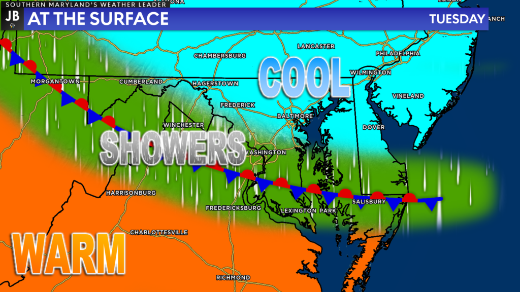
After a rather quiet and seasonal Monday, we will see a warm front slowly cross through the area on Tuesday. This front is likely to stall over some part of our region on Tuesday before slowly lifting northward. We will see rain showers develop along this front, wherever it stalls out. These showers will separate warm air to the south from the cooler air to the north.
Our Chesapeake’s Bounty Futurecast simulates this setup quite well! We are likely to see rain showers develop Monday night and push through the region Tuesday morning before we see a brief period of clearing Tuesday afternoon. Right now, our guidance suggests that we may see up to a quarter-inch of rain from this.
Tuesday PM – Wednesday AM

The break in the rain Tuesday afternoon will be short-lived. While the initial frontal boundary will continue to lift northward, a more widespread swath of rain will push eastward with an area of low pressure. This will move through our region late Tuesday and early Wednesday.
Futurecast shows rain redeveloping across the region by sunset. We will then see the rain tick up in coverage and intensity throughout the night before we see the low-pressure gradually move out of the region Wednesday morning. There could be periods of moderate rain Tuesday night.
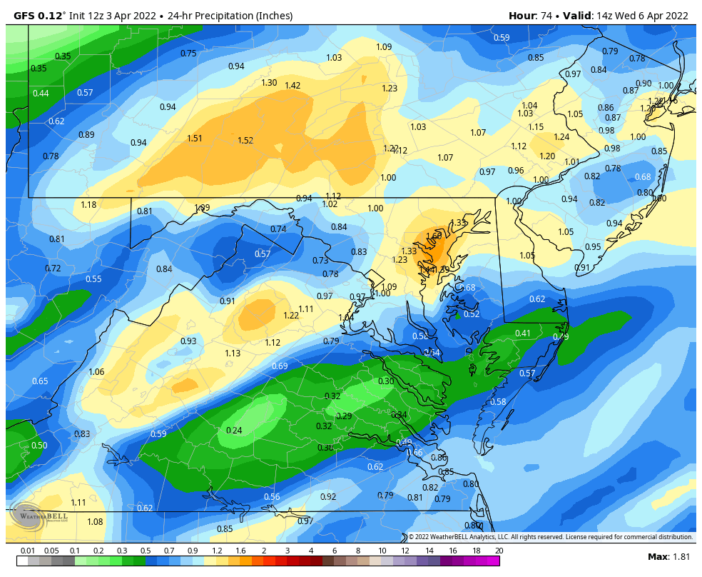
Models suggest that we could see an additional half-inch to an inch of rain between Tuesday night into Wednesday morning. We should see skies clear somewhat by Wednesday afternoon with temperatures that get into the 60s.
Thursday
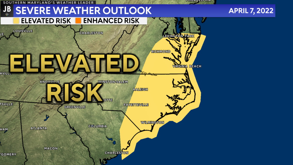
By Thursday we will see an additional area of low pressure move eastward towards our region. This system will bring with it the threat of storms, especially for the lower Mid-Atlantic. Right now, the Storm Prediction Center has included our region in an Elevated Risk for seeing severe weather on Thursday. It is rather uncommon for being 5-days out from the potential event.
The warmer temperatures on Wednesday will look to lay the groundwork for our region to have some storm energy present on Thursday. The greatest amounts of storm energy, and thus the highest storm risk, looks to be centered on the Carolinas and southern Virginia. It is unclear how far north the severe threat on Thursday will be able to get. If we are able to see a strong enough southerly flow on Thursday, which would bring warmer air and the increased storm energy northward, then we could indeed see some storms on Thursday.
Considering how far out we are from this potential event, uncertainty is very high. The details on this potential are sketchy at best. Stay tuned for additional updates on this threat as we get closer to it.
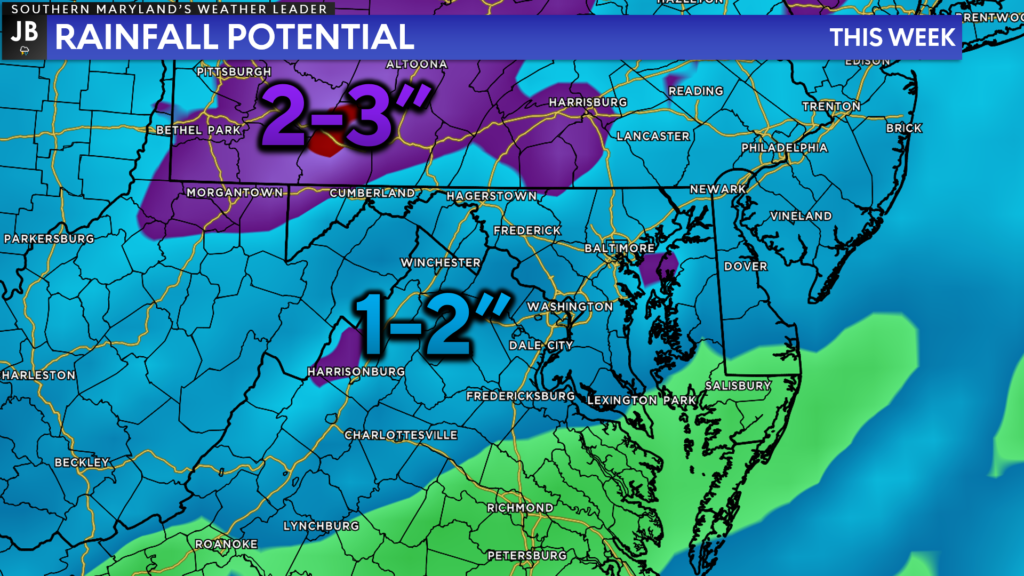
All-in-all we have a rather wet week ahead. We will have several chances for rain with the threat of some thunderstorms come Thursday. Some of our modeling shows the potential for our region to see between 1-2″+ of rain throughout the week! The driest day this week will likely be Monday, so make sure you get out and enjoy it!
I will have additional updates throughout the week on all of these threats. Stay with JB Weather for the latest information on Southern Maryland weather. You can always access my forecasts and updates here on the website, on Facebook, on Twitter, on Instagram, and on YouTube.
-JB

Cedar Point has been providing trusted banking, lending and personal finance solutions to the Southern Maryland Community since 1945. Visit the credit union at any of its 6 locations in St. Mary’s, Charles and Calvert counties or online at www.cpfcu.com.
1 thought on “Forecast: Unsettled Week with Multiple Rain Chances”
Comments are closed.
[…] [ April 3, 2022 ] Forecast: Unsettled Week with Multiple Rain Chances Top Stories […]