Brought to you by Calvert Title Company
We have an active weather day on tap across the Mid-Atlantic. A system from the Plains is moving in, and will spread two rounds of rain across the region; one this morning and the second one this afternoon and evening. Between the two, we should see brief a break which should allow temps to max out in the lower 70s.
I want to first start with the Futurecast, as I think that this is one of the most important tools that could use today. Futurecast shows an initial round of showers moving through this morning, which shouldn’t be too bad. This band of rain will eventually end up parking itself across Northern MD and Southern PA this afternoon. This will allow for a break in the activity in southern spots.
Then, a secondary push of moisture will move in from the south. How warm we end up getting during our afternoon break will determine what kind of weather we end up seeing this evening. At the very least, our second round of rain is likely to move through this evening, and the rain could be heavy at times.
Spots to our south, across Virginia and North Carolina, have the greatest potential to see severe storms develop due to the warmth that they will see. Our region will be on the edge of that warmth. If we see the warm front set up north of our region, we would then see warmer temperatures as well, and a higher severe risk with embedded thunderstorms. The opposite is true if the warm front is to our south.
Futurecast suggests that the bulk of the worst storms will stay to our south, but we could see 1 or 2 try to sneak northward into our region late this evening.

The Storm Prediction Center has placed much of our region under a Level 1 “Marginal Risk” of severe weather for this evening, mainly between 4-11PM. Higher categories of severe weather chances exist to our south, where the higher likelihood of storms exists. Again, our region is on the edge of this threat.
If a couple of storms were to sneak into our region, then the highest threats would come from damaging winds, small hail, and even the potential of 1 or 2 rotating storms that may produce a weak tornado. At this time, a tornado outbreak is not expected across our region. With that said though, this will be something to watch.
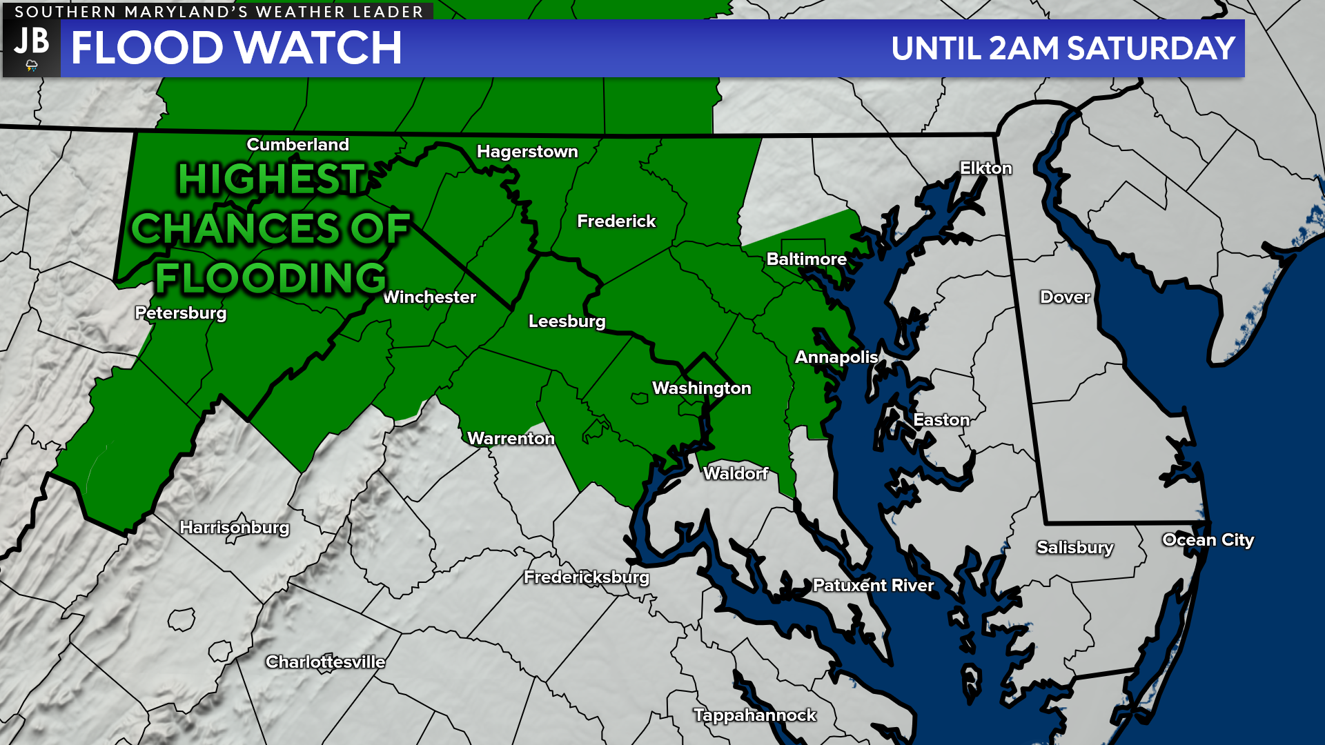
The immense amount of rain will, of course, lead to the threat of flooding across the region. Right now, the National Weather Service has placed northwestern zones under a Flood Watch through tonight. These are the zones that are the most likely to see heavy rain throughout the day.
Our heavy rain threat comes late tonight, which is when our flooding threat will be the highest. With that in mind, I would not be surprised to see this Flood Watch get updated later on today to include more of our region. In any event, be aware as you head out today.
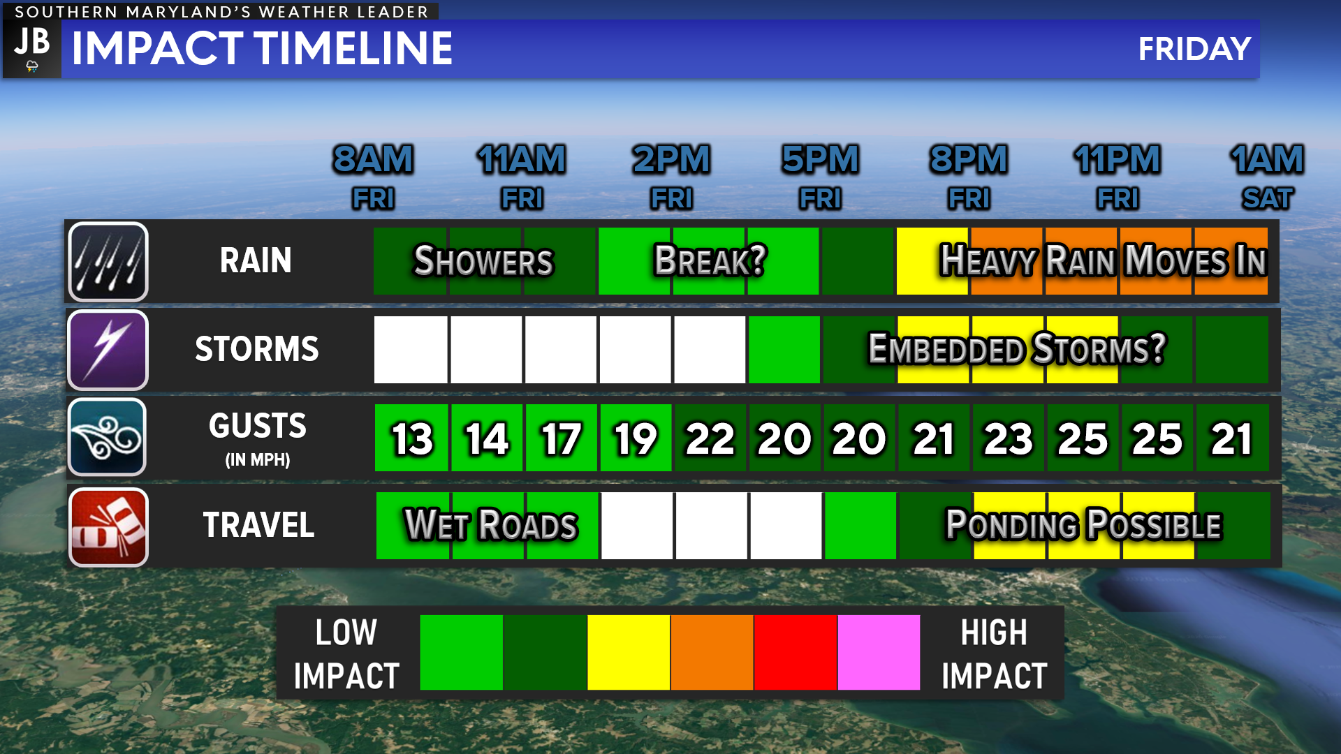
Summary: We are likely to see 2 rounds of rain move through the region today. The first one will be this morning, and likely will not be too bad with just some showers. We will then likely see a midday break in the action before a second round of heavier rains moves in this evening.
The second round of rain this evening may have a couple of embedded strong to severe storms that we will need to watch closely. Our region has been placed under a threat of severe storms this evening. Regardless of storm chances, this second round of rain is likely to bring the more impactful weather to our region. Heavy rain will linger throughout tonight.
Stay weather aware throughout the day. Keep it locked in with JB Weather for the latest information on Southern Maryland weather and the latest developments. You can always access my forecasts and updates here on the website, on Facebook, on Twitter, on Instagram, and on YouTube.
-JB
Brought to you by Calvert Title Company. Calvert Title Company is guiding you HOME one closing at a time! Check out https://calverttitle.com/ today!
John Bordash
View More PostsJB Weather forecaster John Bordash is working around the clock to provide Southern Maryland, and neighboring communities, with accurate and reliable weather information.