Brought to you by Chesapeake’s Bounty
After a quiet start to the hurricane season, we have seen things really ramp up here in late September! We saw Hurricane Fiona bring high impacts to Puerto Rico and Canada last week. Now, all eyes are on Hurricane Ian as this storm eyes the mainland US.
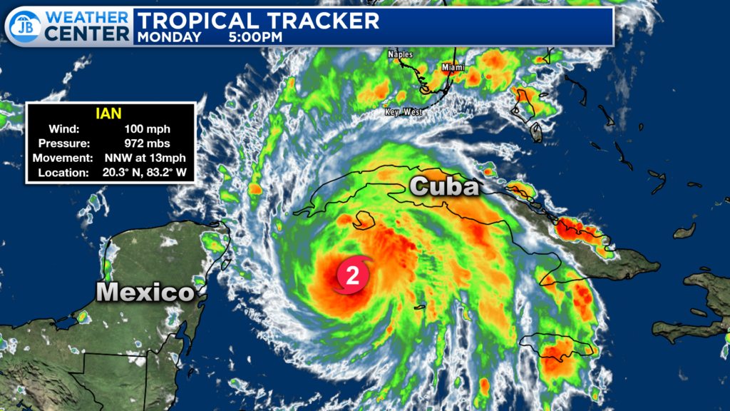
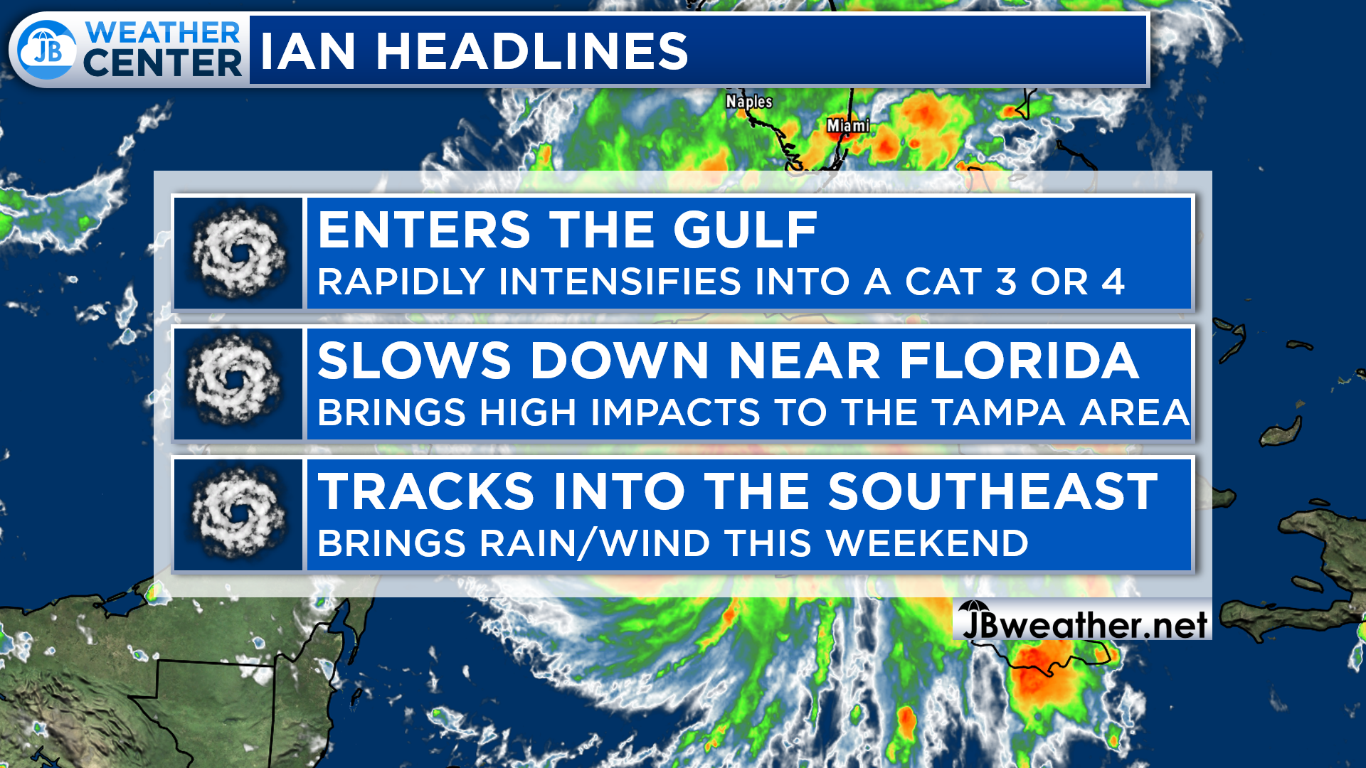
The latest advisory on Ian shows that the storm has now intensified to Category 2 strength with maximum sustained winds of 100mph. This storm is undergoing a period of intensification right now as it nears the tip of Cuba. Ian is likely to make landfall there tonight.
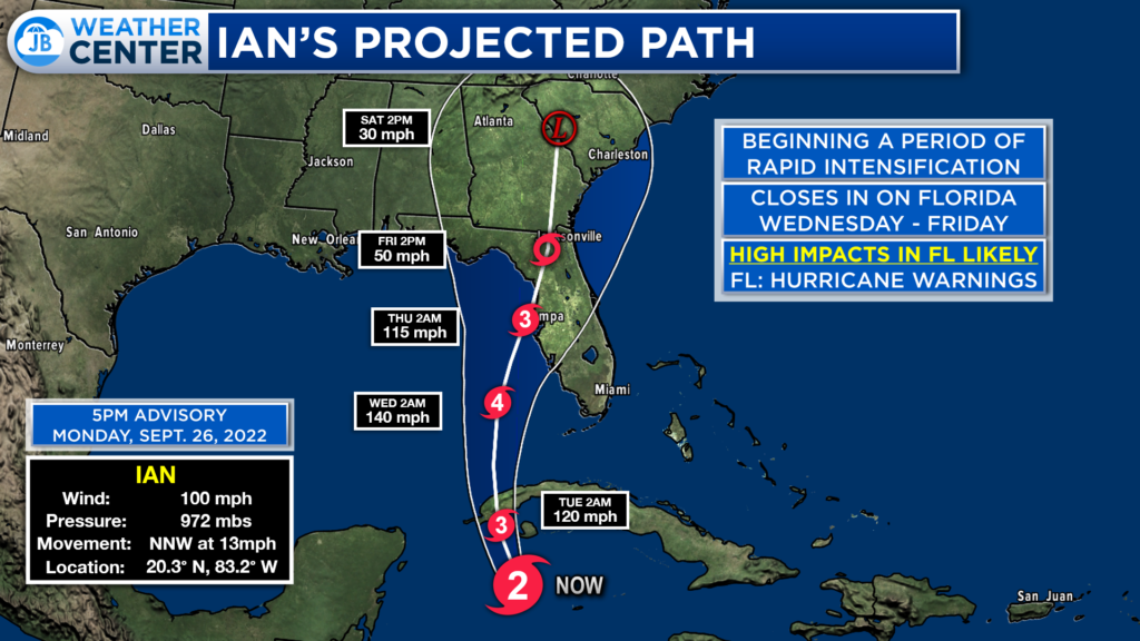
After Ian makes landfall in Cuba, we will see the storm emerge back over open water in the warm Gulf of Mexico. These warm waters will help Ian rapidly intensify, likely reaching Category 4 status by Wednesday. Ian will continue heading north over the next few days, but it is likely to slow down on approach to Florida as the steering currents will break down. Ian will slowly move northward along the Florida coastline late this week before making landfall on Thursday or Friday.
An incoming frontal boundary will interact with a slow-moving Ian, which will help to weaken it some right before landfall. However, it will still bring high-end impacts to the peninsula’s western coast as rain, wind, and surge impact the area.
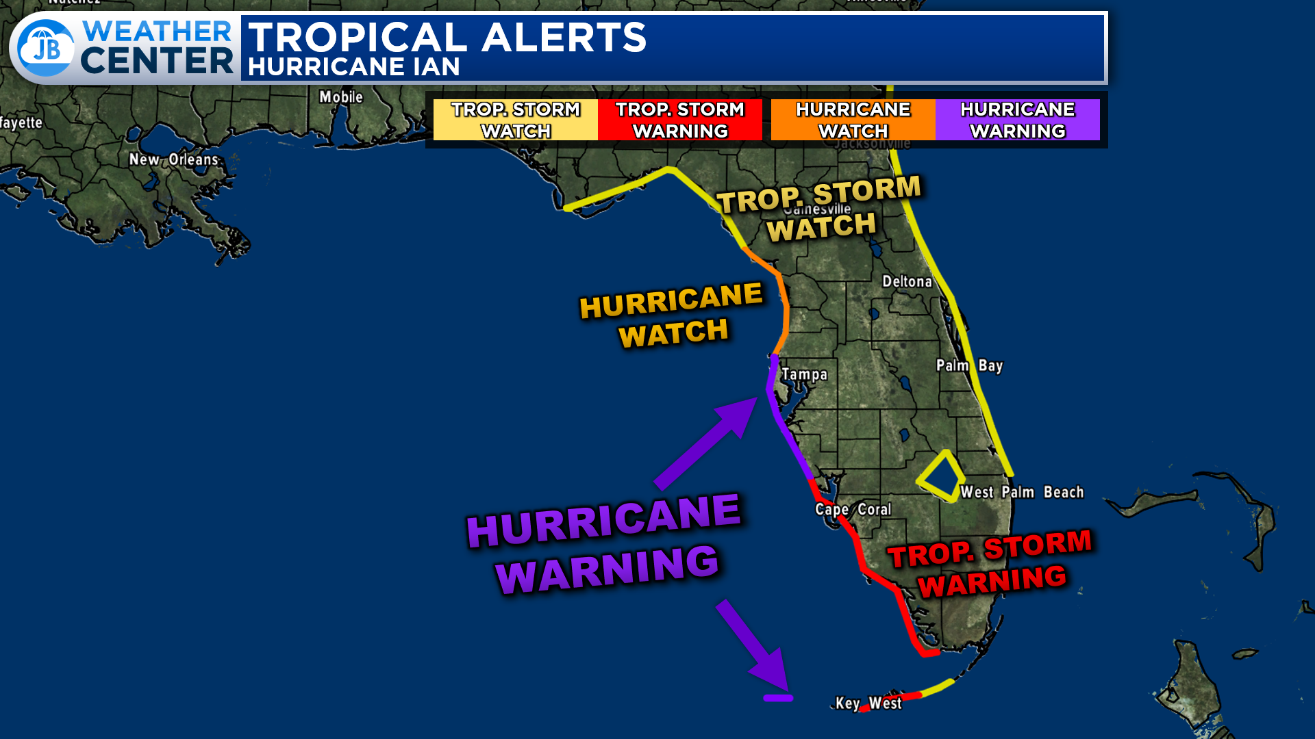
With Ian looking to make landfall in Florida, a plethora of tropical alerts have been issued. Hurricane Warnings are in effect for parts of the Florida Keys and for the Tampa Bay region! This is where hurricane-force winds of over 75mph+ are likely! Outside of that, there are Tropical Storm Warnings, where 40mph+ winds are likely. We also have Hurricane and Tropical Storm Watches for the outer reaches of Florida which show where those conditions are possible.
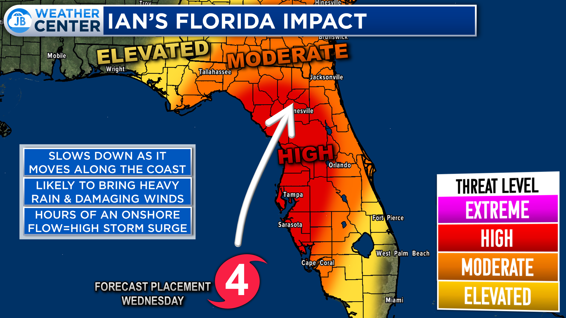
After sitting just off the coastline for about 24 hours Wednesday and Thursday, Ian will likely move onshore somewhere between the Big Bend of Florida and the Tampa Bay area. This means that the highest impacts will be felt in this region as the storm brings a combination of tropical-related impacts to the region. The far southern tip of Florida and the far western panhandle should be spared from the worst of this storm.
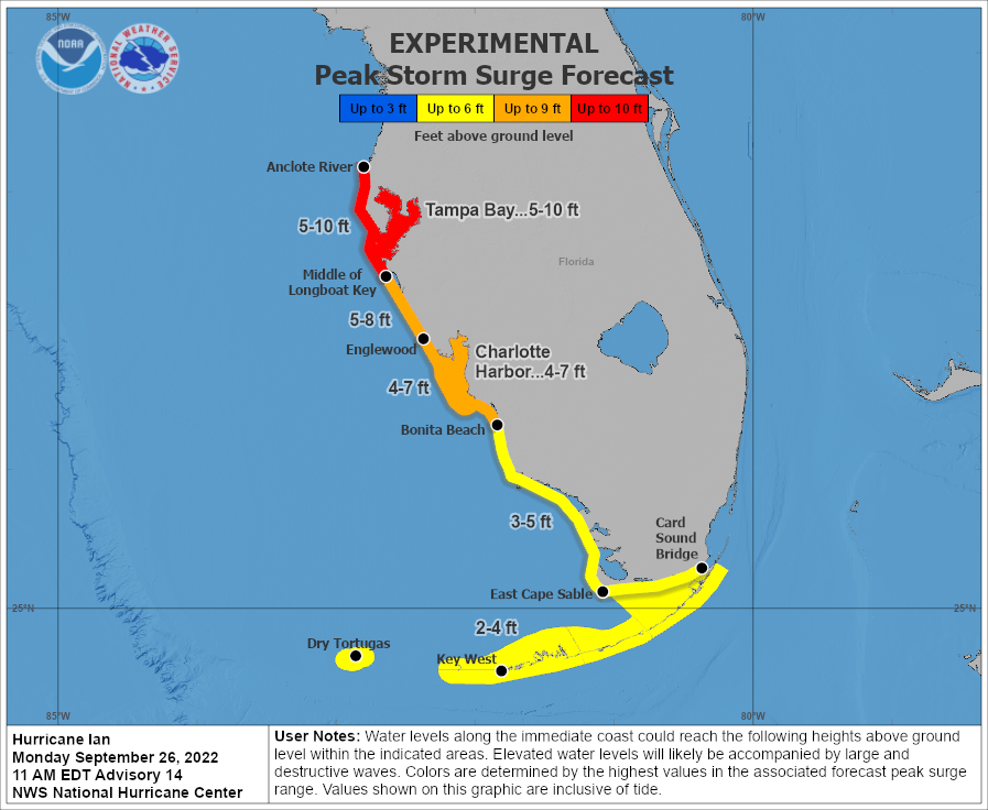
The National Hurricane Center is expecting upwards of 5-10 feet of storm surge in the Tamp Bay area with 4-8 foot levels found further down south, towards Naples. This is an extreme amount of water rise, and will cause life-threatening impacts. This will be exacerbated because Ian will sit offshore for about 24 hours before making landfall. That means that this region could see 24+ hours of onshore winds between 50-80mph, which will pile a lot of water along the coastline.
The high surge is why parts of Hillsborough County, which includes Tampa & St. Petersburg, have been placed under mandatory and voluntary evacuations. This could be a once in a-hundred storm for this region and is something to take seriously. All evacuation orders should be taken.
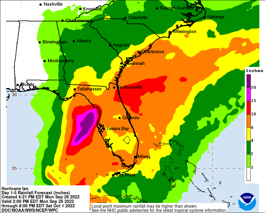
Heavy rainfall is also a threat that Ian poses to this region. The outermost rain bands have already been sweeping across southern Florida, and they will pick up in intensity throughout the week. Some spots could see 6-10″+ of rainfall from this storm as it slowly moves onshore.
What impacts can other parts of the Southeast and Mid-Atlantic expect after Ian makes landfall? Ian will slowly work northward, moving into southern Georgia by Saturday, and into the Carolinas on Sunday. Ian will significantly weaken as it moves inland, but it will bring some gusty winds and heavy rain, potentially up to 2-4″ to the Southeast. The dark green areas could see the heaviest rains this weekend. Winds could gust up to 40-55mph, especially in the red outlined region.
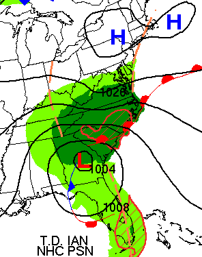
Southern Maryland will be on the edge of seeing impacts. If we do indeed see impacts, which is not a given at this stage, we could see them Saturday, Sunday, and Monday. The impacts we could be looking at would be rain showers that could drop up to an inch of rain and gusts up to 20-30mph. It is too early to speculate on many of the details of what we could or could not see as we are still so far out. You will want to monitor subsequent forecasts for updates.
All in all, Ian looks to pose a significant threat to Florida late this week with heavy rain, between 6-10″+, hurricane-force winds over 75mph, and a 5-10 foot storm surge. All interests in Florida need to take this storm seriously! Ian will likely achieve major hurricane status tomorrow as it enters the Gulf. There are still many questions about Ian’s future as it moves inland and potentially impacts the Southeast and Mid-Atlantic this weekend. Stay tuned for additional updates on that front!
It will be important to stay with JB Weather for the latest information on Ian and the potential impacts across the Caribbean and Southeast US. You can always access my forecasts and updates here on the website, on Facebook, Twitter, Instagram, and on YouTube. JB Weather is Southern Maryland’s Weather Leader, and I am working around the clock to keep you ahead of the storm!
-JB

Chesapeake’s Bounty is providing our community farm-fresh foods from the Chesapeake Bay region. Local seafood, produce, meats, dairy and more! Locations in Saint Leonard and North Beach. Make sure to stop by and also check out www.chesapeakesbounty.com
John Bordash
View More PostsJB Weather forecaster John Bordash is working around the clock to provide Southern Maryland, and neighboring communities, with accurate and reliable weather information.