Brought to you by Berkshire Hathaway HomeServices PenFed Realty
It seems like we do this same song and dance every Memorial Day Weekend. Yes, we are talking about the chance of rain and thunderstorms for at least part of the holiday weekend. The unofficial kickoff to Summer will likely be greeted with rain chances before clearing out for the second half of the weekend.
The system that brought rain to our region Monday evening and Tuesday continues to sit off the coastline, enhancing an onshore flow and the chance for light rain showers. This low-pressure area will slowly move out of the region on Thursday but will continue to enhance the chance for light showers as it does so. As a result, Thursday’s forecast is mainly cloudy skies, the chance of scattered light showers throughout the day, and easterly winds.
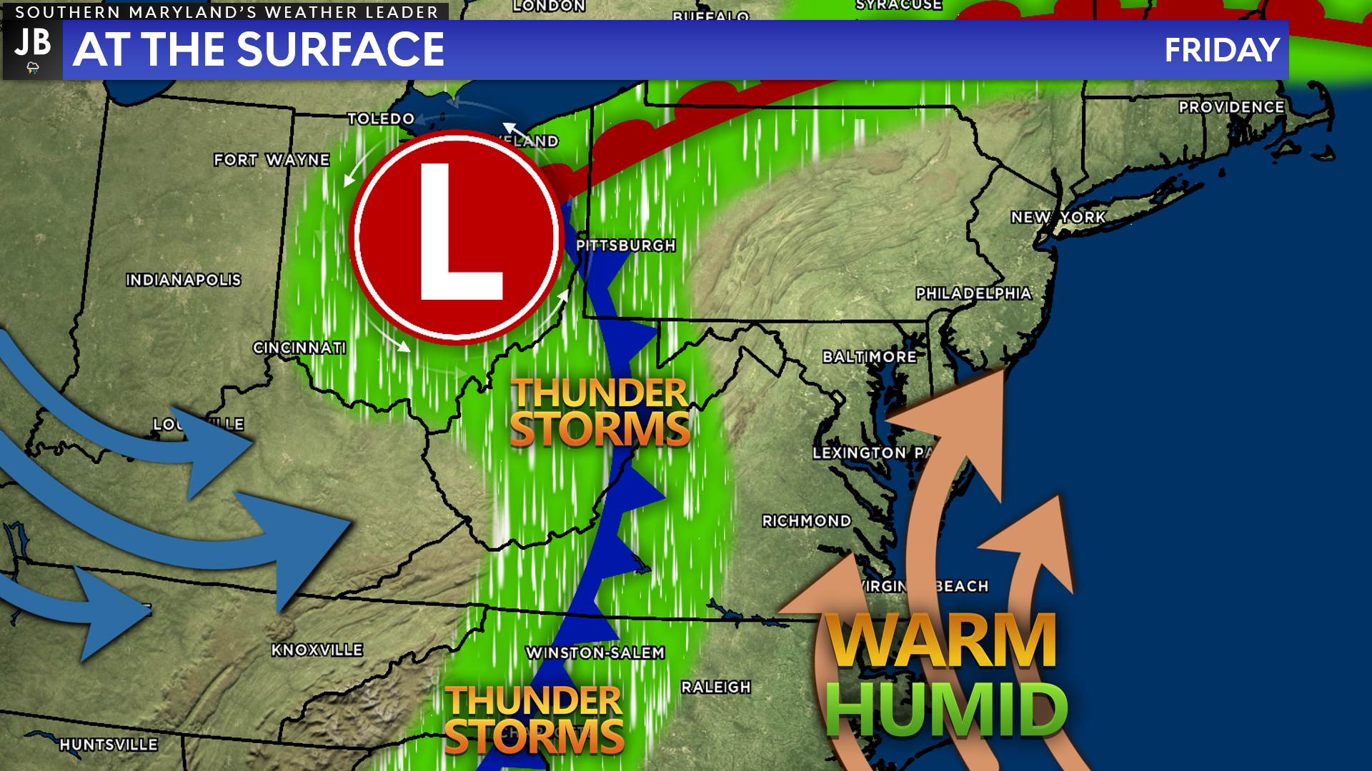
On Friday, our eyes will turn back to the west as a frontal system will look to make its way eastward. Out ahead of the front, warm and humid air will funnel into the region. This will set the stage for a wet and potentially stormy afternoon and evening on Friday as the front moves through.
As the front moves through Friday evening, we may see a couple of lines of storms move through with it. Details are sketchy right now on the specifics, and they will come into better focus the closer we get to the event. With that said, there is definitely the potential for these lines of rain to possess some stronger to severe storms. In conjunction with gusty winds in the middle levels of the atmosphere, the warmth and humidity will potentially serve as the ingredients for severe weather.
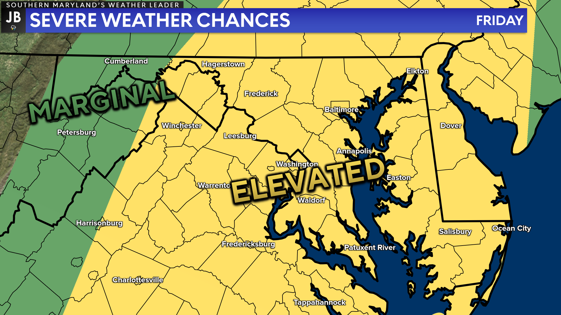
The Storm Prediction Center has already placed our region under a Level 2 “Elevated Risk” of severe storms for Friday afternoon and evening. The main risks with these storms appear to be damaging winds, but we cannot rule any modes of severe weather right now. This would likely affect the evening commute and anyone traveling for the holiday weekend.
It will be important to stay weather aware Friday evening, especially if you are headed eastward to the beaches for the holiday weekend. I would suggest leaving either before lunchtime on Friday or waiting until Saturday morning to avoid potential difficulties. However, as always, stay tuned to this forecast as it is prone to change.
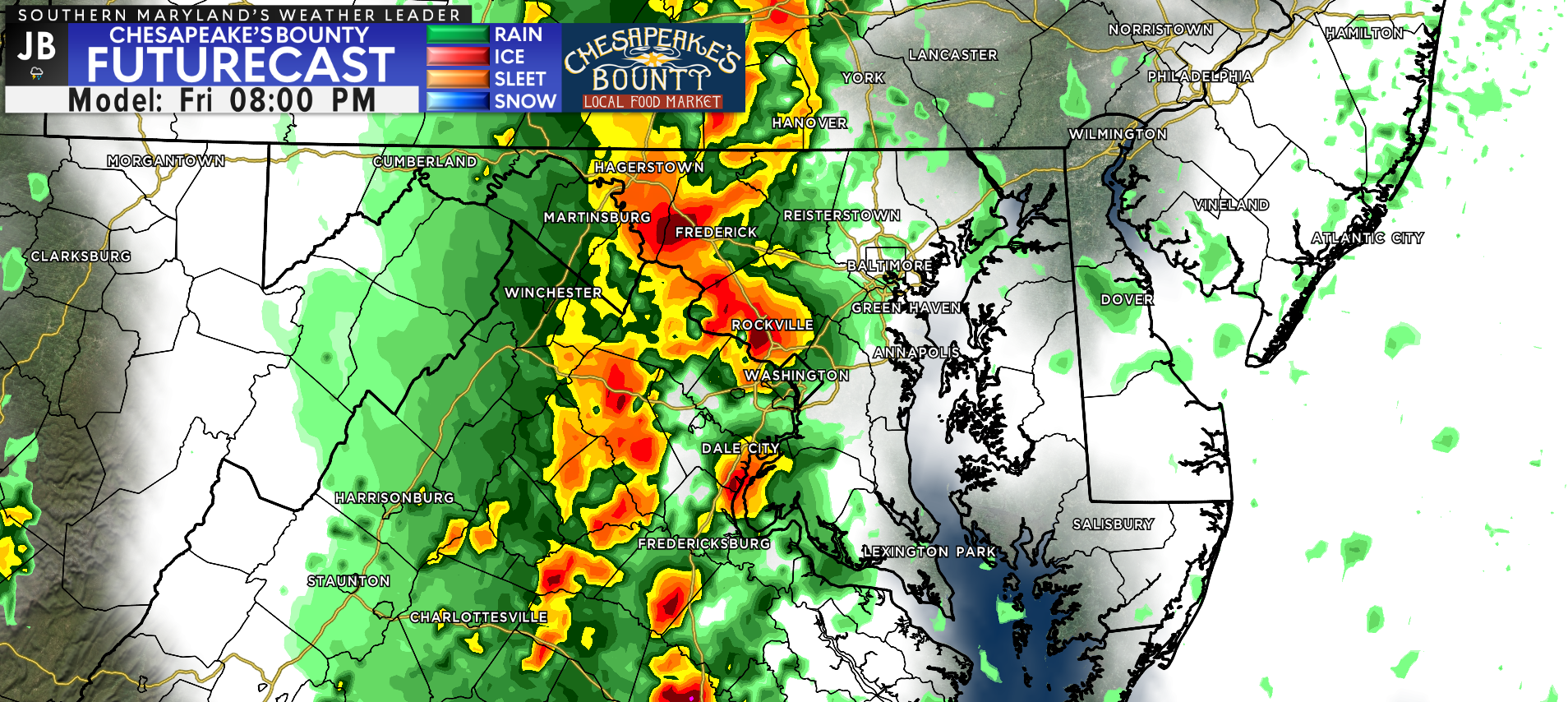
Looking ahead, the threat of rain will linger into Saturday as well, thanks to a moist, southerly flow that will continue. The threat of rain showers throughout the day on Saturday is high, but I’m not sure I would call it a total washout. Our Futurecast model, shown above, shows that scattered areas of rain are likely throughout the day, but they are not likely to continue everywhere all day.
There will be an additional threat of thunderstorms Saturday afternoon as well. We are too far to detail specifics. I would expect for weather impacts throughout the day Saturday and start to think about what a Plan B would look like for any outdoor plans.
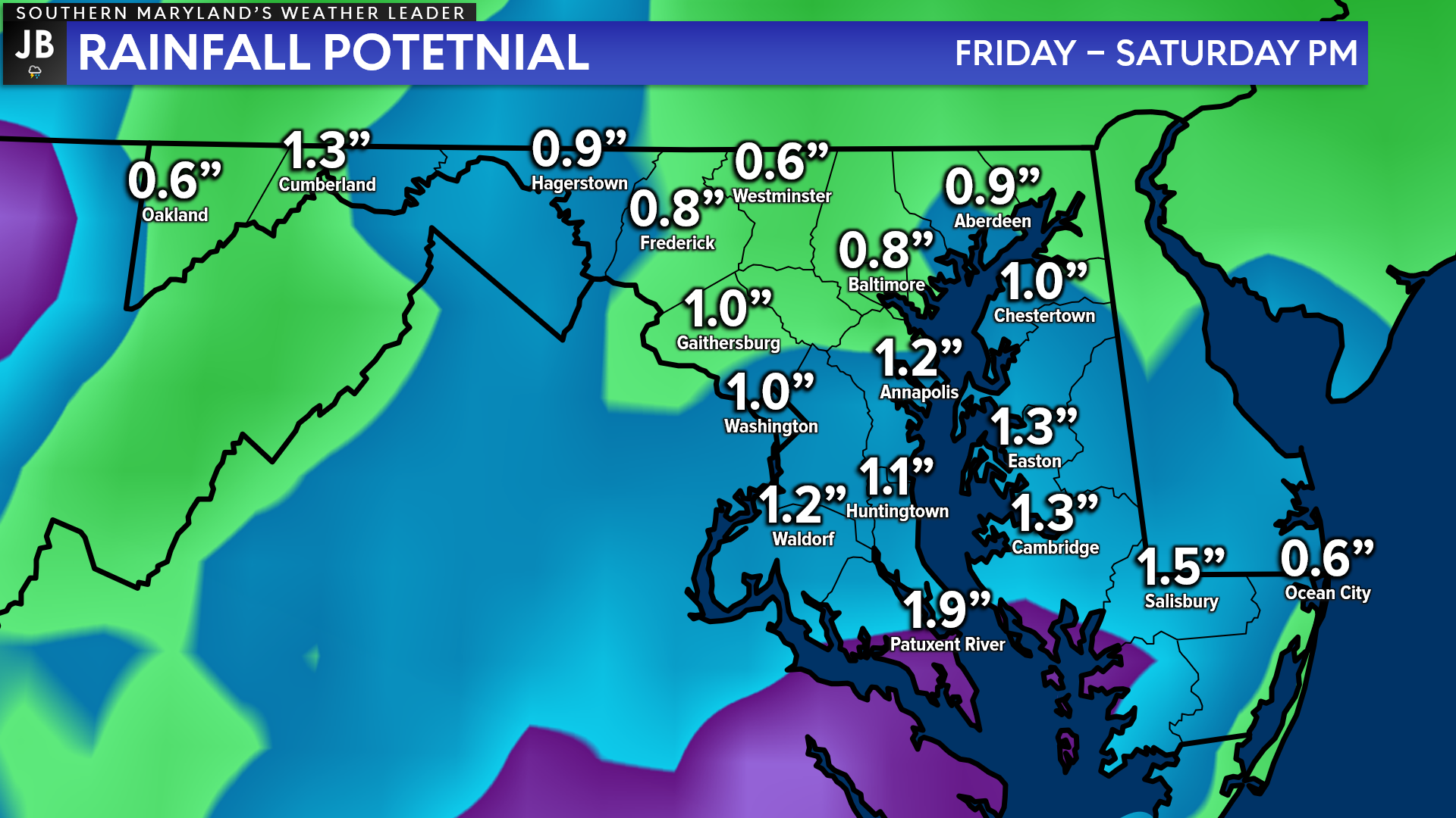
Our Futurecast shows the potential for another 1-2″ of rain across the region as we start the holiday weekend between Friday and Saturday. I would take these numbers with a grain of salt, though. This time of year, rainfall can vary a lot by location, thanks to the spotty nature of late Spring rains. With that said, though, this amount of rain, on top of what has already fallen this month, could lead to some instances of flooding.
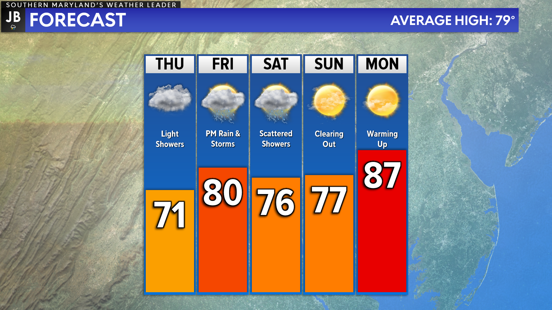
After a wet start to the weekend, we are likely to dry out for the last half of it. We may still have some spotty showers around Sunday morning, but we should be drying out Sunday afternoon. Monday looks dry and warm as temperatures start to climb into the middle to upper 80s!
As mentioned earlier, the specifics with this forecast are very much prone to change as we learn more about the atmospheric players driving this forecast. Stay tuned for additional updates, especially with Friday’s forecast. Friday would be the day that I would be the most concerned about for weather impacts. Sunday afternoon and Monday look much better!
Stay with JB Weather for the latest information on Southern Maryland weather. You can always access my forecasts and updates here on the website, on Facebook, on Twitter, on Instagram, and on YouTube.
-JB

Real Estate now! Not sure where to start? View our Southern Maryland inventory of homes, land, farms and commercial properties on penfedrealty.com. Engage with our planning tools to determine your next real estate lifestyle decision, choose your realtor as a trusted advisor. Experience the difference with service and support from real estate’s forever brand!
John Bordash
View More PostsJB Weather forecaster John Bordash is working around the clock to provide Southern Maryland, and neighboring communities, with accurate and reliable weather information.

1 thought on “Memorial Weekend to Get Started with Rain/Storm Chances”
Comments are closed.
[…] [ May 25, 2022 ] Memorial Weekend to Get Started with Rain/Storm Chances Top Stories […]