Brought to you by Bill Oosterink, Realtor
Snow wrapped up earlier than expected this morning, but it still delivered within the lower end of the forecast range. Most areas southeast of D.C. picked up 2–4 inches, while northwest of D.C. saw closer to 4–7 inches before precipitation transitioned over. From here on out, this storm is no longer about snow.
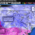
Current Radar & Conditions
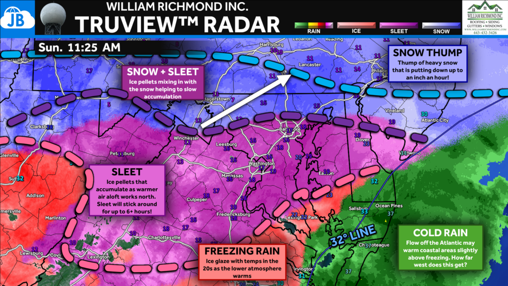
Radar shows a widespread and solid shield of sleet across much of the region, with snow now fully shut off. Sleet pushed into D.C. as early as around 8 AM, several hours sooner than many expected, confirming a faster surge of warm air aloft. Surface temperatures remain locked in the teens and 20s, which means everything falling is sticking efficiently. Roads that were snow-covered this morning are now seeing ice pellets piling on top of compacted snow, making travel increasingly difficult and noisy underfoot.
Futurecast / What’s Ahead
Looking ahead through the afternoon and evening, we do not go back to snow. The dominant precipitation type will remain sleet for many areas, while warmer air continues to work northward aloft. This sets the stage for a gradual transition to freezing rain southeast of I-95, especially toward southern Maryland and the Tidewater. Precipitation remains steady through the evening before tapering late tonight.
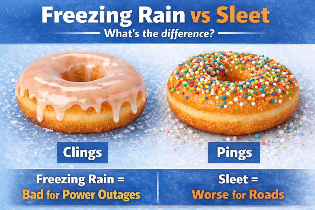
Sleet and freezing rain behave very differently. Sleet “pings” off surfaces and piles up, making roads extremely slick but limiting damage to trees and power lines. Freezing rain, on the other hand, clings to surfaces—coating roads, power lines, and trees with ice—making it the bigger concern for power outages and infrastructure damage.
Sleet Forecast & Hazards
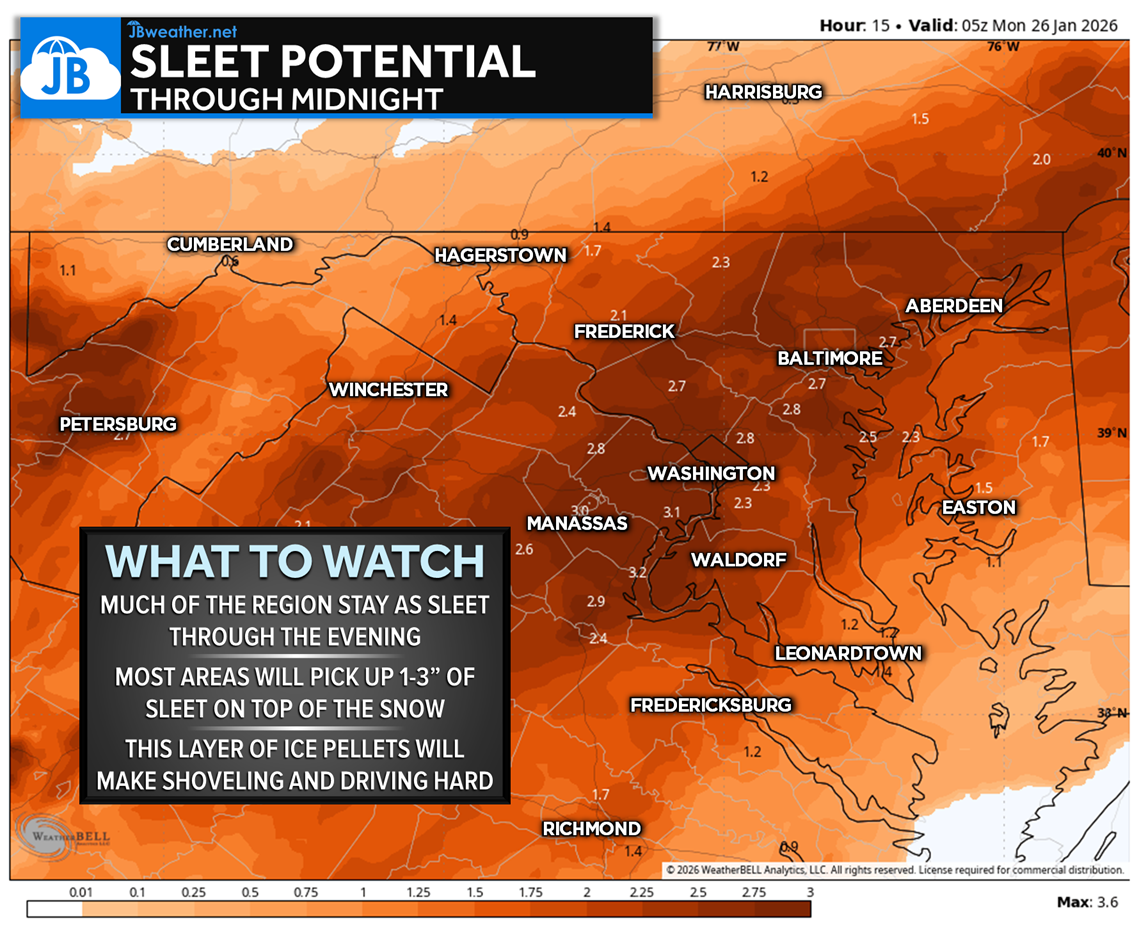
The sleet map shows a large and persistent swath of sleet across much of the region through the afternoon and evening. The highest sleet totals are expected from northern Virginia through central Maryland, including the D.C. metro, where colder air at the surface remains locked in while warm air aloft continues to surge north. Farther northwest, sleet amounts will be somewhat lower as colder air remains deeper, while southeast of I-95, sleet will gradually give way to freezing rain as surface temperatures inch closer to freezing. Overall, this is a long-duration sleet event, not a brief transition.
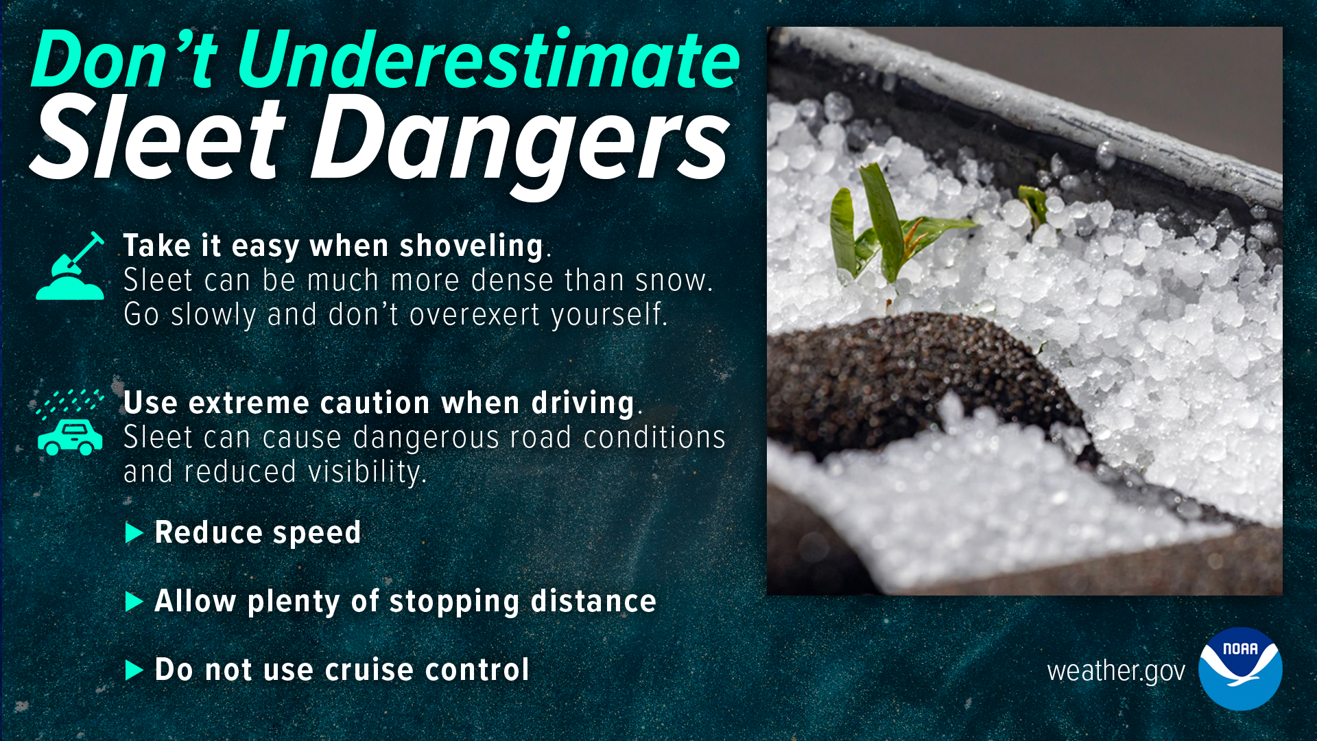
The hazards graphic highlights why sleet is often underestimated. Sleet is dense and heavy, meaning even 1–3 inches adds significant weight on top of earlier snowfall. This will make shoveling extremely difficult, increase strain on roofs and trees, and keep roads slick despite treatment efforts. Unlike snow, sleet does not compact smoothly, leading to uneven, icy driving surfaces that remain hazardous well into the evening. These impacts will linger even after precipitation begins to taper.
Ice Forecast
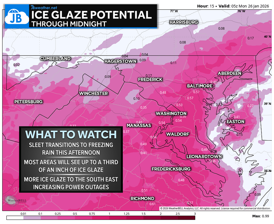
As sleet gradually mixes with and changes to freezing rain southeast of I-95, icing concerns ramp up. While ice accretion amounts vary, up to a few tenths of an inch of glaze is possible in the most vulnerable areas. Even light glazing is enough to cause problems when combined with earlier snow and sleet, especially on untreated roads, trees, and power lines.
Power Outages
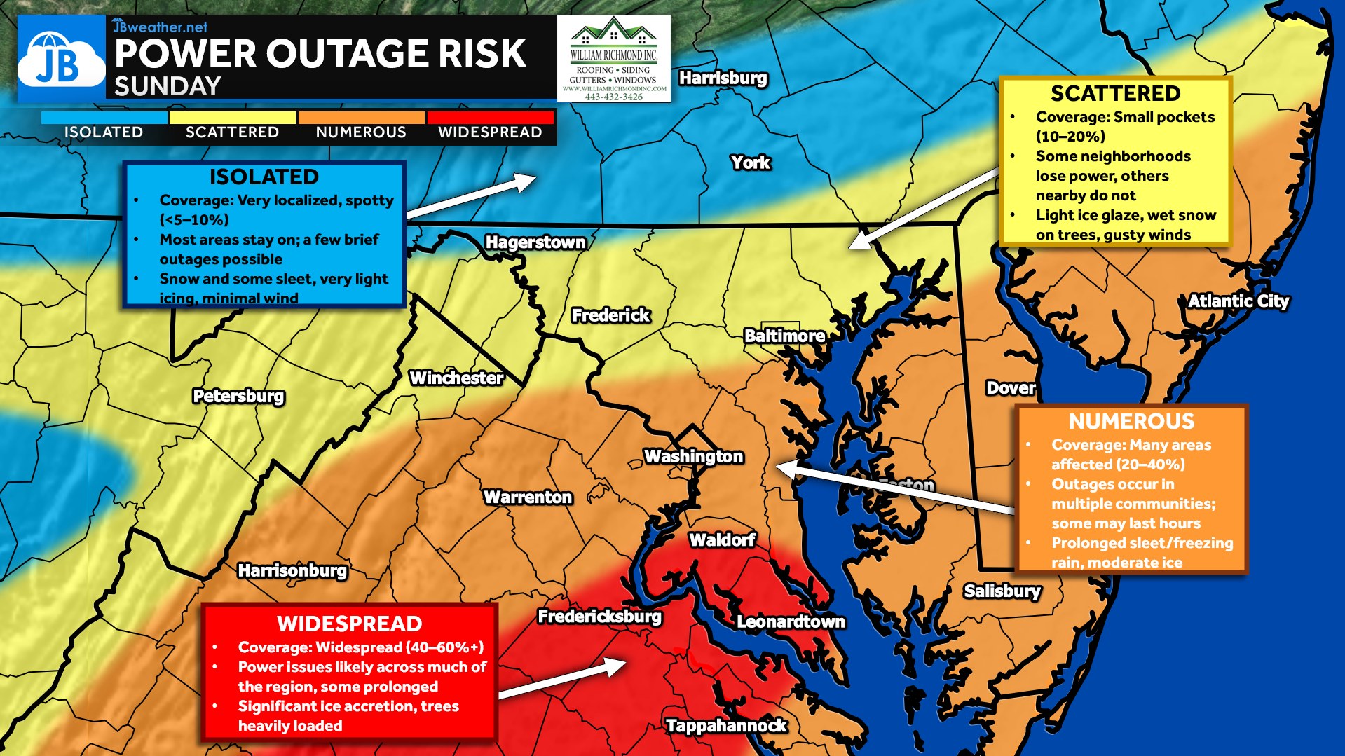
Power outage risk is numerous to widespread, particularly across southern Maryland and into the Tidewater. Ice loading on trees and lines, combined with gusty winds, raises the likelihood of outages — some of which could be prolonged. Crews may have difficulty accessing areas while sleet and freezing rain continue.
Bottom Line
The snow part of this storm is finished, but impacts are far from over. Sleet will dominate through the afternoon and evening, with freezing rain increasing southeast of I-95. Travel will worsen, power outages are likely in harder-hit areas, and impacts will linger into Monday, which is why school closures and delays are already beginning to roll in. Continue to avoid unnecessary travel and prepare for extended disruptions.
Stay with JB Weather for the latest information on impacts here in Southern Maryland and across the Mid-Atlantic. You can always access my forecasts and updates here on the website, on Facebook, on Twitter, on Instagram, and on YouTube. JB Weather is the Mid-Atlantic’s Weather Leader, and I am working around the clock to keep you ahead of any storm!
Buying. Selling. Investing. Ready when you’re ready! Check out www.somdDreamHome.com today!
John Bordash
View More PostsJB Weather forecaster John Bordash is working around the clock to provide Southern Maryland, and neighboring communities, with accurate and reliable weather information.
2 thoughts on “Midday Update: Sleet Taking Over & Icing Risk Increasing”
Comments are closed.
11:39 Sunday January 2026
Here in Lisbon, Maryland in Western Howard County it has had freezing rain coming down for at least an hour +. In your estimate, when will we see all this precipitation stop in our area? Thanks for your forecasting acumen.
When will the freezing rain begin?