Brought to you by Bill Oosterink, Realtor
Forecast confidence continues to slowly increase with a developing winter storm expected later this weekend into early next week. While many aspects of the forecast remain unchanged from last night, there are subtle but important trends emerging in the latest model guidance that are worth highlighting this morning.
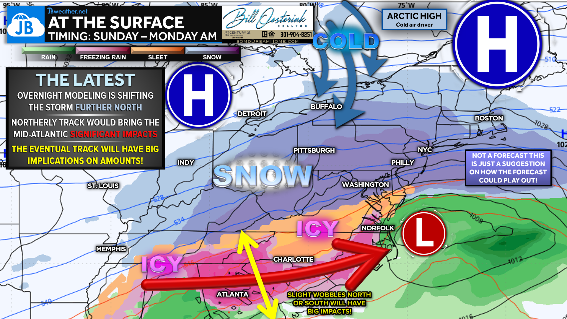
Overnight and early-morning modeling has begun to shift the storm track slightly farther north. If this trend continues, it would increase the potential for more significant winter weather impacts across the Mid-Atlantic, as the storm would interact more directly with cold air supplied by a strong Arctic high to the north. At this range — still 4–5 days out — these solutions are far from locked in, but a northward shift is a meaningful signal that forecasters will continue to monitor closely.
Along with the northward trend has come a change in timing. A farther-north track typically results in a slower-moving system, and current guidance is now pointing toward a primarily Sunday into early Monday morning event. As always, small adjustments north or south will have major implications for precipitation type, amounts, and impacts across the region.
Bottom line: While model trends are worth noting, it remains too early to determine exact snowfall totals, timing, or local impacts. Any responsible forecast at this stage will reflect that uncertainty. We will enter a more reliable forecasting window tomorrow, when higher-resolution guidance becomes available and confidence in the details begins to improve.
Stay with JB Weather for the latest information on impacts here in Southern Maryland and across the Mid-Atlantic. You can always access my forecasts and updates here on the website, on Facebook, on Twitter, on Instagram, and on YouTube. JB Weather is the Mid-Atlantic’s Weather Leader, and I am working around the clock to keep you ahead of any storm!
Buying. Selling. Investing. Ready when you’re ready! Check out www.somdDreamHome.com today!
John Bordash
View More PostsJB Weather forecaster John Bordash is working around the clock to provide Southern Maryland, and neighboring communities, with accurate and reliable weather information.