Brought to you by Berkshire Hathaway HomeServices PenFed Realty
This weekend ended on a damp note as we saw rain begin to move into the region yesterday. Some spots picked up to 1-2″ of rain as showers and downpours moved through, especially during the afternoon and evening hours. This soggy weather will continue for today as a cold front slowly heads eastward.
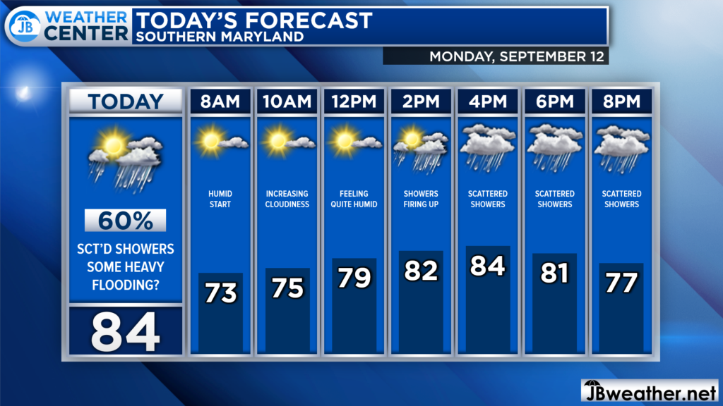
We are off to a humid and damp start this morning. Temperatures are in the 70s and dewpoints are also in the 70s, which is causing some patchy fog out there. We will see just a couple of peeks of sunshine this morning before we see rain chances spike to over 60% this afternoon and evening.
Futurecast shows today’s weather story well. We likely will not have much going on this morning besides some morning fog. After lunchtime, we will start to see showers and storms fire up to our west. These showers and storms will head eastward throughout the afternoon, likely reaching Southern MD by the evening rush hour. Showers and storms will likely continue throughout the evening and into tonight.
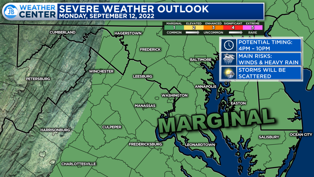
The Storm Prediction Center has placed our region under a Level 1 “Marginal Risk” of severe weather for this afternoon. This denotes the low chance of seeing a couple of storms turn strong to severe with gusty winds and heavy rain. Widespread severe weather is unlikely. The primary timing would be from 4-10PM.
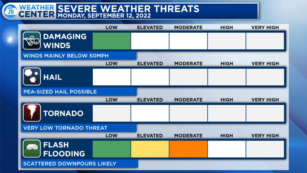
Not everyone will see a thunderstorm today, some may just see showers or a downpour. However, those that do see thunderstorms could see them pack a punch with gusty winds up to 50-55mph and flooding rains. You will want to stay weather aware this afternoon and evening.

Our region has also been placed under a heightened threat of flash flooding today. Much of the region is either under a Level 1 “Marginal Risk” or a Level 2 “Elevated Risk” of seeing flash flooding this afternoon and evening. This means that numerous downpours could lead to scattered flooding.
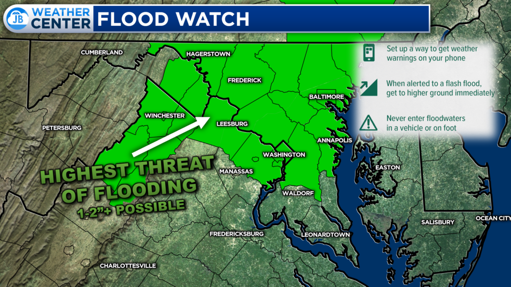
Our most vulnerable spots to see flash flooding are in the urbanized areas centered along I-95. That is where a Flood Watch, shown in green, has been issued from 5pm-12am. I would not be shocked to see this expanded further south, including Southern MD. All areas will have the potential to see up to 1-2″ of rain today. The exact placement of those highest amounts will come down to where the downpours are set up.
All in all, expect a high-impact weather day. A humid start will give way to developing showers and storms this afternoon and evening. Some storms could be strong to severe with gusty winds and heavy rain. As a result, flooding is a concern today. I would cancel outdoor plans and activities for today and move them inside. Stay weather aware this afternoon, and bring the umbrella with you!
Stay with JB Weather for the latest information on Southern Maryland weather. You can always access my forecasts and updates here on the website, on Facebook, on Twitter, on Instagram, and on YouTube.
-JB

Real Estate now! Not sure where to start? View our Southern Maryland inventory of homes, land, farms and commercial properties on penfedrealty.com. Engage with our planning tools to determine your next real estate lifestyle decision, choose your realtor as a trusted advisor. Experience the difference with service and support from real estate’s forever brand!
