Brought to you by Bill Oosterink, Realtor
One system is out, and another rolls in! Our next system will look to move through Saturday afternoon through Sunday morning. With a northerly track, we are likely looking at a wintry mess with a variety of precip types. One thing is certain: expect widespread impacts Saturday that linger into Super Bowl Sunday.
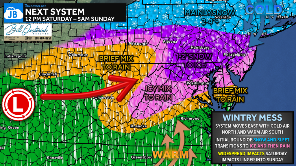
Much of the DC region should start as a snow/sleet mix after lunchtime. However, warm air from the south will quickly transition that over to ice and then to rain. Areas from Fredericksburg to Waldorf and north could see up to a tenth of an inch of ice before rain! Areas north of Baltimore should see 1-2″ of snow before up to a quarter inch of ice. These zones will end as a brief period of rain. The coastal plain may start with a couple of hours of mix before transitioning to rain.
Regardless, expect widespread slick spots and difficult travel Saturday afternoon until at least Sunday mid-morning. Impacts linger longer the further north you head.
Stay with JB Weather for the latest information on impacts here in Southern Maryland and across the Mid-Atlantic. You can always access my forecasts and updates here on the website, on Facebook, on Twitter, on Instagram, and on YouTube. JB Weather is the Mid-Atlantic’s Weather Leader, and I am working around the clock to keep you ahead of any storm!
Buying. Selling. Investing. Ready when you’re ready! Check out www.somdDreamHome.com today!
John Bordash
View More PostsJB Weather forecaster John Bordash is working around the clock to provide Southern Maryland, and neighboring communities, with accurate and reliable weather information.

1 thought on “Next System Set for the Weekend”
Comments are closed.
[…] Story continues […]