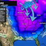
Our wet pattern with mild temps is likely to stick around to close out 2024. However, we are likely to see our pattern flip back to a cold pattern to kickoff 2025. The cold is likely to be prolonged for a couple of weeks (at least) thanks to a deep dip in the Jet Stream.
Our average high is 43°, so this would favor highs in the 20s/30s. The big question here though, is how active the storm track would be. We run the risk of the Jet Stream being so deep that the cold air suppresses all storms well south (across the Gulf Coast and then out to sea). However, if we could sneak a system a bit further north, the cold air would allow for winter weather chances! Now let’s be clear, these would not be huge winter weather storms. My background leads me to believe we should be able to sneak at least one storm northward for a modest storm.
Let me be clear here, there is not one specific threat or storm that I am currently tracking. These are just generalities and possibilities at this point. It’s sort of like saying that Philadelphia should have beaten Washington last week… but then things happened. Right now, we are just on standby mode to watch. With that said, as a winter weather lover, I do generally like the pattern we have setting up for the new year. There are lots of questions, but they will get ironed out in due. Two things are certain, though…
1) It’s about to get quite cold
2) There will be PLENTY hype posts from people who want to make money off your clicks & people who don’t know better. Stay with trusted sources. As the haters will say, “y’all can’t forecast more than 3 days out!” So don’t buy 10-day+ snow maps.
1 thought on “Pattern Change Ahead”
Comments are closed.


[…] Source link […]