Brought to you by R.E. Graves Heating & Air Conditioning
Wow– it is crazy to see how much the forecast has changed over the last 24 hours. We have seen our computer models trend much further to the north and west with our developing coastal storm. Our models have also shown our storm having much more moisture and precipitation to work with. I raised totals considerably this morning in lieu of this. These trends have not stopped today, and it looks like I will need to raise my snow totals again. If you are looking for a quick summary of the forecast, take a look at the Storm FAQs and Summary sections, towards the bottom of the page.
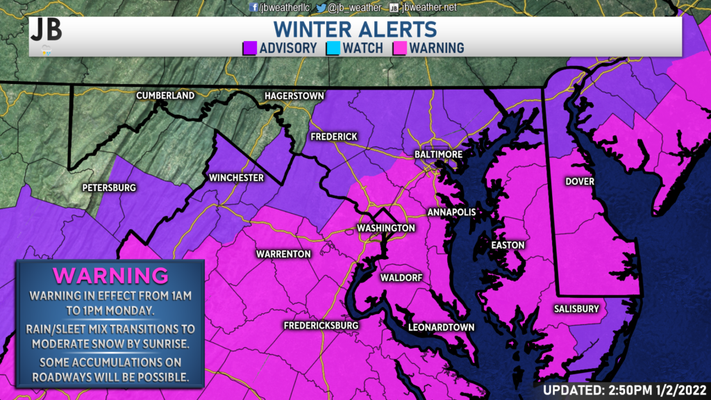
As of 3pm Sunday, much of the region has been upgraded to a Winter Storm Warning, shown in the pink, from 1am until 1pm Monday. This is the zone where significant and impactful snowfall looks likely. Within the warning area, it looks like we could see some accumulation on roadways, significantly impacting travel.
Timing the Precip & Colder Air
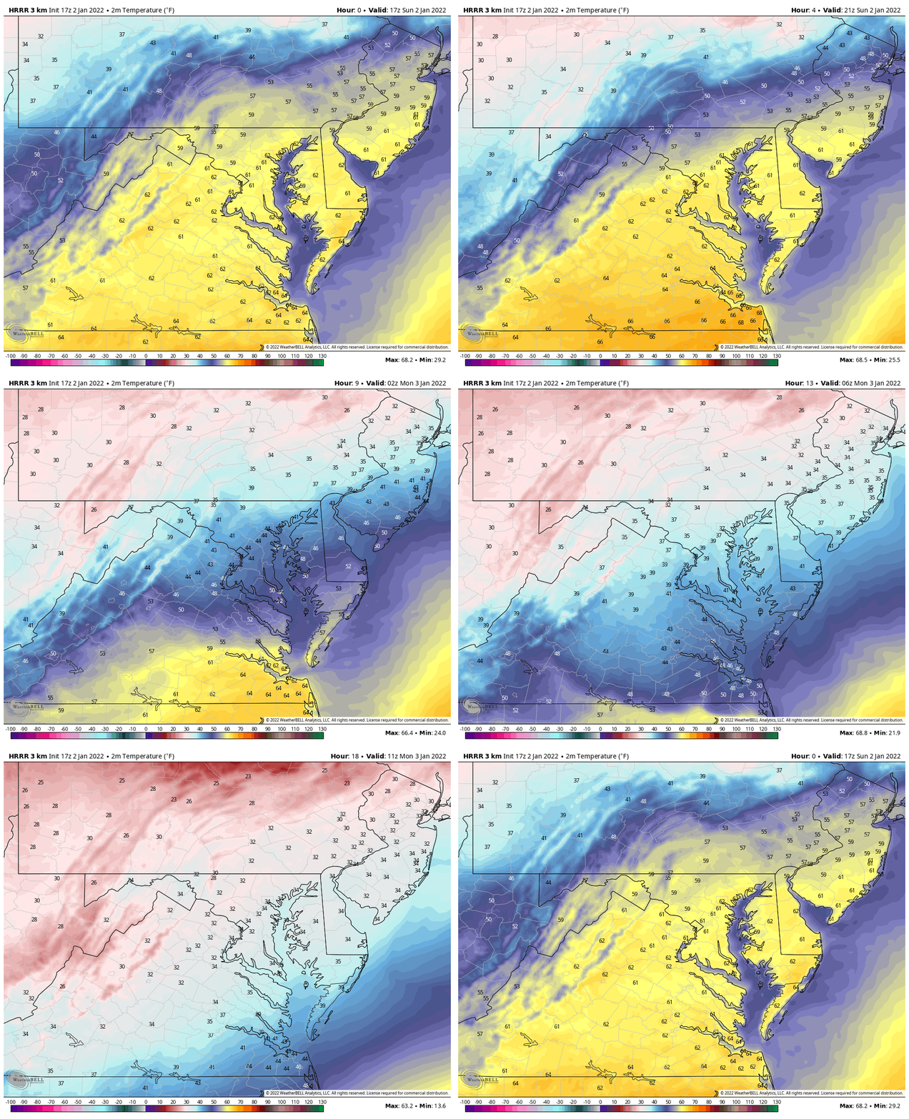
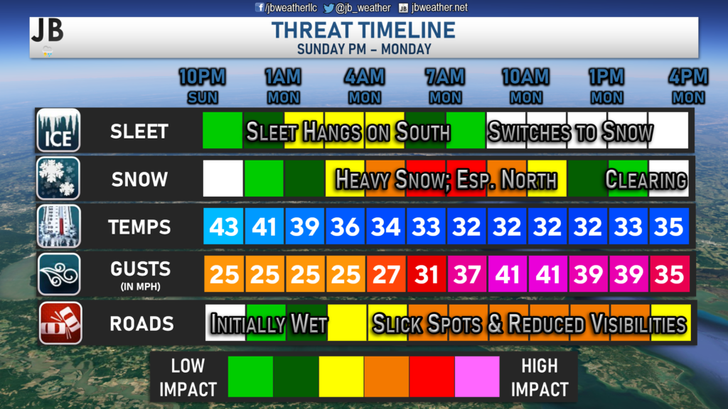
We have been talking for days about the drastic temperature drop we would see Sunday night and Monday morning. Sure enough, highs have topped out in the lower 60s and upper 50s this afternoon. However, were still on schedule to have our cold front move through this evening, and usher in colder air into the region. Shown above is a depiction of the temperatures swing we could see between Sunday evening and Monday morning. Gusty northwest winds will help deliver the shot of cold air, potentially cooling temperatures by around 30° in just about 12 hours.
Our Chesapeake’s Bounty Futurecast (shown above) has been doing a great job of showing the potential with this winter storm. The latest run of Futurecast shows that precip will look to move into the region around 10pm Sunday night. Temperatures will still be in the 40s and 50s at this time, so any precip would likely start as all rain. However, as colder air filters in the region overnight, the rain will change over to snow from north to south. By midnight, we could start seeing some sleet and snow work down into Southern MD. Futurecast has several hours of moderate to heavy snow across the region throughout the mid-morning hours. It is during this time that we could see heavy snow bands set up that produces 1-2″ of snow PER HOUR! Futurecast has the snow beginning to calm down by lunchtime and pushing out throughout the afternoon.
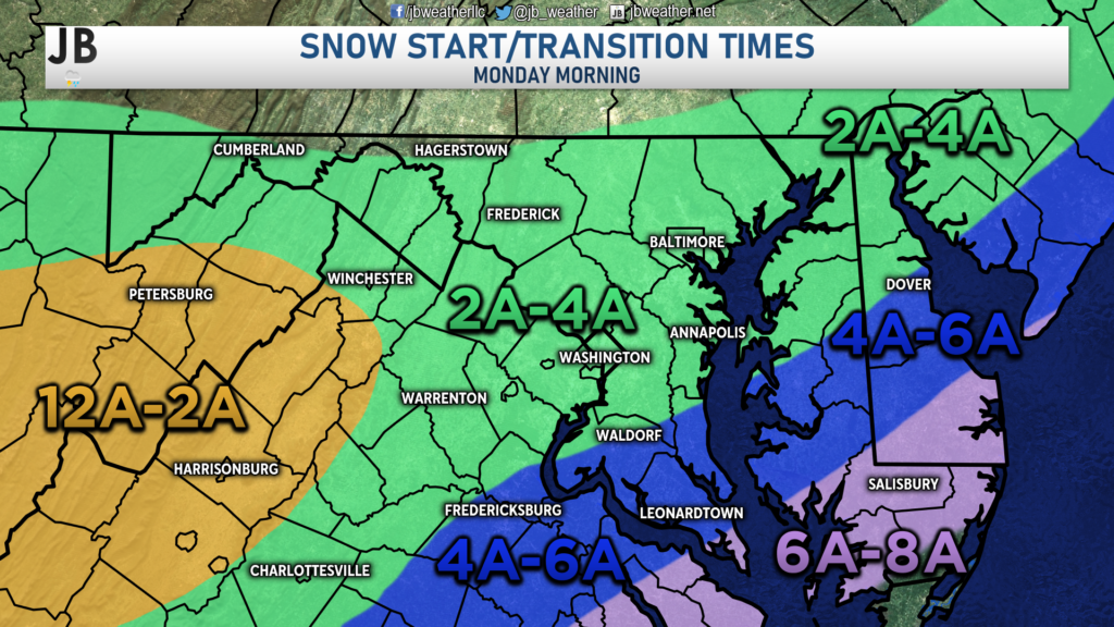
With all of that in mind, you can see my general expectation of snow arrival times on the map above. We will likely see snow break out in northern areas just after midnight, as that is the zone where the cold air will arrive first. We should see any initial rain transition to sleet and then to snow fairly quickly between 2AM-4AM from Waldorf to Annapolis, and points north. For much of our region, we should see a transition to snow between 4am-6am after an hour or so with some sleet. Sleet will hang on the longest across far southern St. Mary’s County, where they should transition over to snow by 6am-8am.
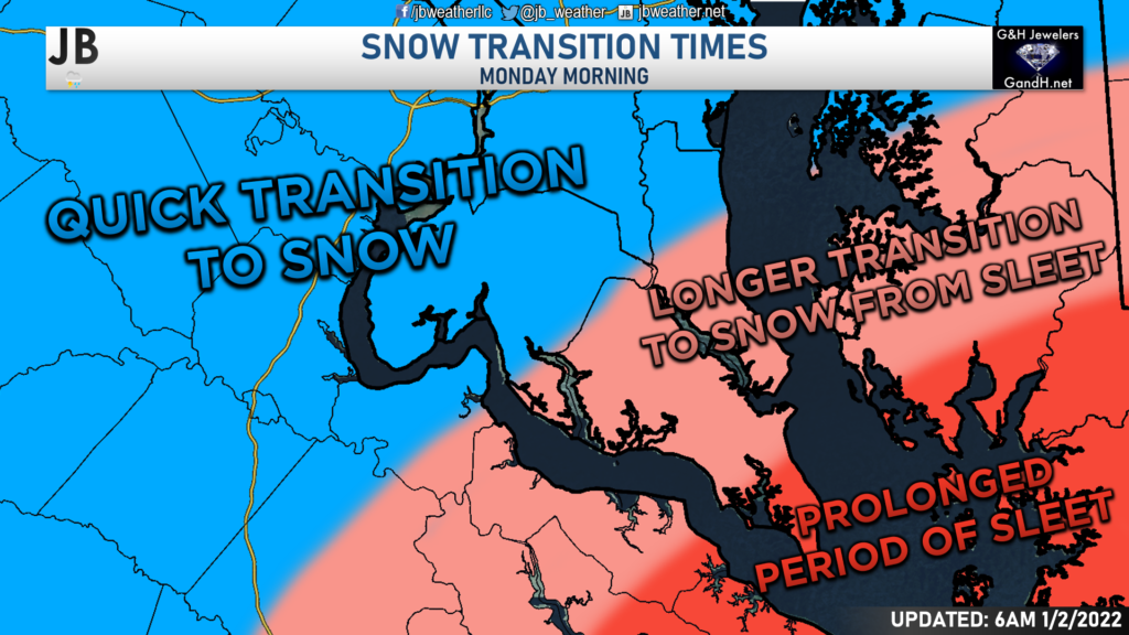
While I do expect all areas to switch over to snow by sunrise, areas in the light pink may see an hour or two of sleet before the transition, whereas areas in blue should not see much more than an hour of sleet. Any time spent with sleet will cut down on snow totals. While the northwest trend has helped to push heavier snow into our area, it also pushes the sleet line further northwest. Any additional ticks northwest could lead to the sleet area moving further north as well.
We should see a few hours of light to moderate snowfall across the region between sunrise and lunchtime. Our Futurecast model even has some spots of heavy snow. While I think that may be overdone a tad, it does show the possibility of localized banding leading to some locally higher snowfall totals. This system should push out of Southern Maryland by early to mid-afternoon.
Accumulation Map
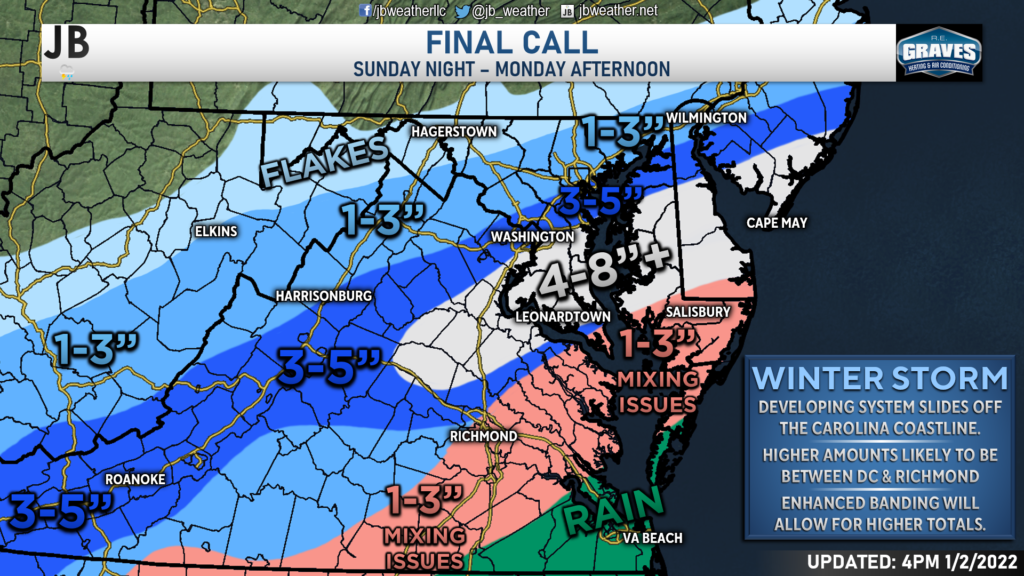
The northwest trend with this storm has continued and it now looks very likely that most areas in Southern Maryland will get in on a significant snowfall. The bullseye remains centered over our region, with 4-8″ of snow looking likely, with locally higher amounts. Amounts will lower across far southern St. Mary’s County, where the additional hours of sleet will likely cut down on totals. With that said, if that zone can switch over quick enough, they too could get in meaningful snow. Amounts will also drop off the further northwest you head from DC. The snow is likely to be lighter there, and not last as long.
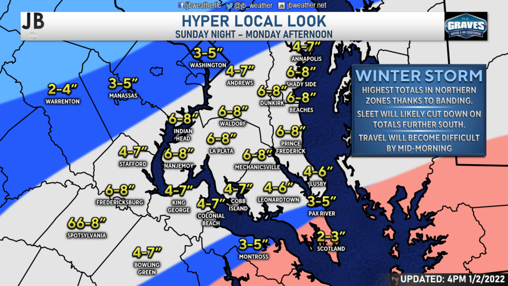
Locally, the highest totals will likely be found from Shady Side-Dunkirk-Brandywine down to Prince Frederick-Mechanicsville-Newburg. This is the zone that will likely have minimal issues with sleet and should see some moderate snows. Many communities in this zone are likely to pick up 6-8″ of snow, with some locally higher amounts in 1 or 2 communities. South of there, totals are a smidge lower as these spots may have issues with sleet mixing in for a prolonged period. Southern Calvert and central St. Mary’s Counties are likely to see 3-6″ of snow, with far southern St. Mary’s County potentially only seeing a few inches. Like I said above, if the sleet can transition over quicker in this zone, then the tip of St. Mary’s may also be able to get in on 4-6″ amounts. Amounts will tapper off as you head north. Southern PG and central Anne Arundel Counties should still be in good spots to see 4-7″ of snow. DC will likely see 3-5″, with 1-3″ north of there.
Regional Impacts
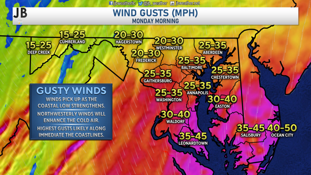
In addition to the winter weather, we will also have to contend with gusty winds! Winds are likely to gust between 30-45mph southeast of I-95 as the coastal low strengthens. This will reduce visibilities & lead to blowing snow. This will also enhance the deliverance of cold air.
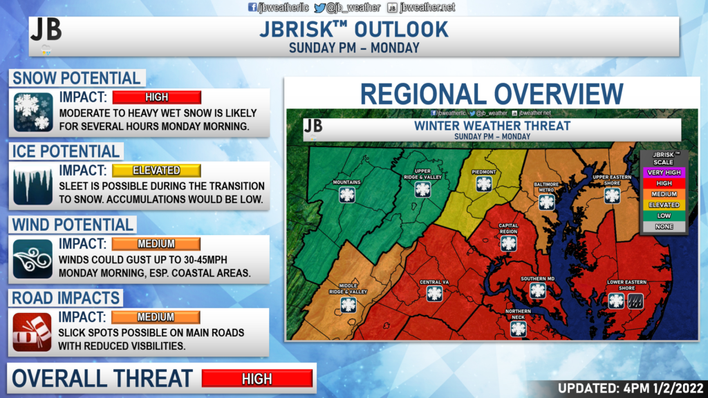
This storm is looking like it will indeed bring high impacts to the region. This is because the threat of heavy snow has increased, which will lead to higher accumulations. The ice potential for Southern MD has increased a tad, granted is mainly for those southern zones that we talked about. While I am not expecting freezing rain in that area, there could be 1-2 hours of sleet that accumulate up to a quarter or half an inch. Winds will be gusty on Monday as colder air rushes into the region.
I am now also expecting medium roadway impacts. While most of the accumulation will occur on grassy and colder surfaces, we could see slick spots form– especially on secondary roads. Roadway temperatures will be warm after such a warm weekend. For that region, I think the main roads should be fine, initially. However, if we see moderate to heavy bands of snow set up, they may overcome those warm road temps as the snow would pile up quicker than it could melt. This is something to keep in mind, especially north of Prince Frederick and La Plata. This will likely pose impacts on the Monday morning commute and could impact school and business schedules.
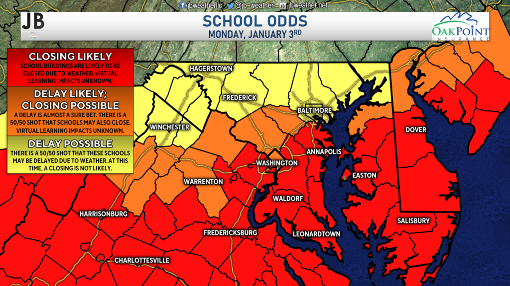
Shown below are School Odds forecast for Monday. With a significant winter storm set to impact the region, there’s over a 90% likelihood that schools south of DC will close for tomorrow. This does NOT take into account the potential for virtual learning. I am aware that a few districts, such as Charles County, had previously scheduled this week for virtual learning. Consult with your district about procedures for snow days.
Storm FAQs
How confident are you in your forecast? My confidence in this forecast is growing. Confidence is above average that we will get at least some accumulating snow, mainly due to the amount of cold air that will be diving into the region and the abundant moisture associated with this storm. This cold dry air to the north is causing this storm to take a more southerly track, which bodes well for Southern Maryland snow hounds.
Where will the heaviest snow fall? The highest totals look likely to be concentrated in an area from Prince Frederick-Mechanicsville-Newburg up to Brandywine-Dunkirk-Shady Side. This small region looks to be the best position to see bands of heavy snow set up, which may produce 6-8″. Some communities in this small area may even see localized 8″+ amounts if the bands of heavy snow set up just right
When will the snow start? Current guidance shows that the snow may begin very early Monday morning, likely between 2am – 6am. However, rain may begin falling around 10pm Sunday night before we switch over to snow.
When will the heaviest snow fall? Probably during the morning hours between sunrise and lunchtime south of the DC metro region. Some bands of moderate to even heavy snow may impact area during this time.
When will the snow end? The storm looks to last longer in duration than earlier thought. Current indications show that the snow should be winding down after lunchtime, and should be out of no later than sunset.
How much snow will I get at my house? Check out the accumulation map. Generally, I’m expecting 4-8″ for most of the region, with lower totals across southern Calvert and southern St. Mary’s (thanks to sleet) and north of DC (thanks to lighter precip rates).
Could more or less snow fall than currently forecast? Absolutely. In order for even more snow to happen, we would need to see heavy snow bands develop right over Southern MD. Colder temperatures would also lead to more snow, as opposed to sleet, for southern zones. On the other hand, if the storm takes a slight jog to the south, or if the air is not as cold, many areas will struggle to see much. In light of these plausible scenarios, here’s my assessment of snowfall probabilities:
10% chance: Nothing
15% chance: 1-3″
40% chance: 3-6″
35% chance: 5-8″+
As you can see, we have at least a 75% chance of seeing 3″ of snow across the region. Chances are also rather higher that some spots could indeed see 5-8″+.
Will the snow stick? It is likely that we see snow accumulation on grassy areas, and on colder surfaces. While it can snow a day after getting into the 60s (it has happened many times before), it is hard to get that snow to stick to the warm blacktop on roadways. Snow will have a hard time accumulating on the main highways unless a heavy band sets up. Secondary and back roads may see slick spots develop by mid-morning though.
Any chance of a wintry mix of freezing rain or sleet? While freezing rain is unlikely, the chances of seeing sleet with this storm are moderately-high. Most areas will likely see a period of sleet as the rain transitions to snow. Areas north Route 231 (running from Prince Frederick to La Plata) will likely only see an hour at a max of sleet before getting in on snow. Areas south of Route 231 may see a couple of hours of sleet with this storm before the switch over to snow happens. Sleet pellets accumulate more like snow and not like freezing rain. While it can make surfaces slick, I am not expecting an ice glaze with this event. Some southern zones though could see up to a half-inch of sleet pellets with this storm.
Summary
Chances are high that Southern Maryland will see its first significant winter storm in nearly three years! We have a developing system sliding to our south as cold air filters into the region Monday morning. Areas south of DC are the areas that are the most likely to see snow out of this setup. This storm has trended further north and west, with a lot more moisture, leading to increased snow chances in Southern MD. Accumulation and impacts are likely across Southern MD for Monday morning. Right now, 4-8″ seems probable for most, with communities in southern Calvert and southern St. Mary’s Counties seeing more like 3-5″. Gusty winds will also be present around the region, with coastal communities potentially seeing wind gusts up to 45mph at times. The combination of winter weather and gusty winds means that it is likely that all travel on Monday will be impacted. While roadway temperatures are likely to be warm at first and melt any snow, the high snow rates we may see will likely overcome this. At the very least, secondary roads are likely to see accumulation, with some sticking even being possible on area highways.
It will be important to stay with JB Weather for the latest information on this winter storm and its impacts here in Southern Maryland. You can always access my forecasts and updates here on the website, on Facebook, on Twitter, and on YouTube. JB Weather is Southern Maryland’s Weather Leader, and I am working around the clock to keep you ahead of the storm!
-JB

R.E. Graves Heating & Air Conditioning is a ⭐️⭐️⭐️⭐️⭐️ HVAC Contractor serving St Mary’s & Calvert. Just mention JB Weather to Save 20% off your next Heating repair bill when you Book now! regraveshvac.net/jbweather20off
