Brought to you by Chesapeake’s Bounty
Today begins a stretch of our hottest weather yet this summer. While we have seen high humidity over the last few months, we have lacked the typical summer heat we are used to in the Mid-Atlantic. Today, that high heat kicks into gear. With the heat, we will also see, yet another, threat of thunderstorms this evening.
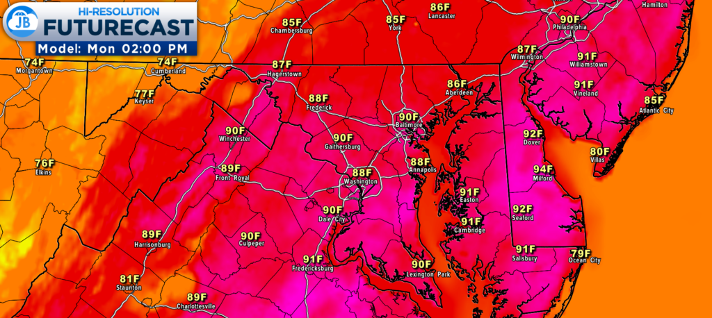
Futurecast shows many areas east of the Blue Ridge maxing out in the lower 90s this afternoon. With dewpoints also sitting in the lower 70s (which is quite oppressive), we will see our heat indices soar to near 100. It will be important to try and stay cool and hydrated this afternoon! This heat & humidity combination will also lay the groundwork for the risk of storms this evening.
A weak wave of atmospheric energy will push through the region this afternoon and evening. As it does so, it will look to set off storms across the Mid-Atlantic and Northeast. Futurecast shows this well, developing a broken line of storms around rush hour, and pushing it eastward through the evening.
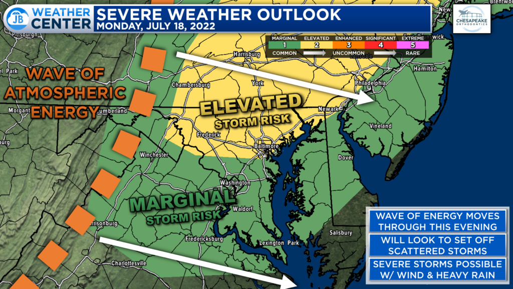
The greatest risk of seeing severe storms, from this wave of energy, will be focused from DC northward to New York State. That region has already been upgraded to a Level 2 Risk of severe weather. This is where severe storms are the most likely to push through this evening.
Areas south of DC remain under a Level 1 “Marginal Risk” of severe weather. This denotes a lower chance to see widespread severe storms. While the storms may not be as strong south of DC, I do still think that we will see a few storms develop and push through our region between 5pm-midnight.
The Storm Prediction Center is already monitoring northern areas for the high likelihood of having a severe weather watch get issued later this afternoon. The blue polygon, in the tweet shown above, is the primary risk area for severe weather. It remains to be seen whether that severe watch and risk zone will be extended further south. Regardless, this does highlight where the greatest severe risk exists.
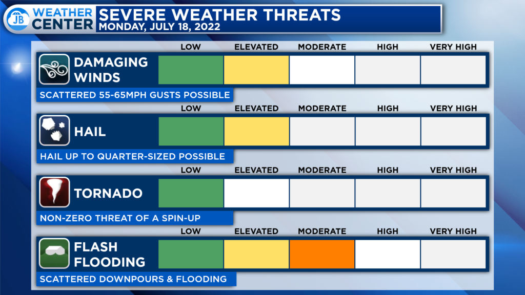
The primary severe weather risk with any storms that fire up will be the potential for storms to produce damaging winds up to 60mph and large hail up to 1″ in diameter. There is also a non-zero threat of a spin-up tornado. However, that tornado threat seems to be the highest north of the Mason Dixon line.
There is also a notable threat of localized flash flooding today. Today’s storms should be moving at a good clip. However, they will be able to put down a quick inch or two of rain in a short amount of time. Over the last couple of weeks, we have seen storms bring parts of our region a lot of rain. This means that additional heavy rain could lead to localized flash flooding.
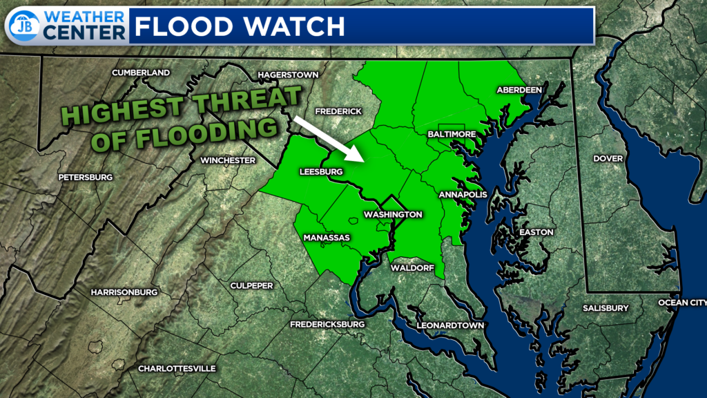
The DC & Baltimore Metro Areas have been placed under a Flood Watch (indicated by the green shaded counties) from 4pm-midnight tonight. While everyone has the risk of heavy rain this evening, this is the zone that is the most vulnerable to flooding. Some could see a quick 1-3″.
If you have outdoor plans this afternoon and evening, I would not cancel them. However, I would have water with you. And, I would recommend stay weather aware as hot and miss storms try to fire around lunchtime. Have a Plan B ready to go, and be ready to act if quickly-changing weather conditions move overhead.
Stay with JB Weather for the latest information on Southern Maryland weather. You can always access my forecasts and updates here on the website, on Facebook, on Twitter, on Instagram, and on YouTube.
-JB

Chesapeake’s Bounty is providing our community farm-fresh foods from the Chesapeake Bay region. Local seafood, produce, meats, dairy and more! Locations in Saint Leonard and North Beach. Make sure to stop by and also check out www.chesapeakesbounty.com
