Brought to you by All in One Tag & Title
The last week has offered some rather dramatic swings in our weather. Last weekend we were in the midst of our first heatwave, just to see temperatures plunge into the 60s with days of cloud cover and rain chances. Tomorrow will offer up another swing in our weather as severe thunderstorms and flooding rains look possible to kick off Memorial Day Weekend.
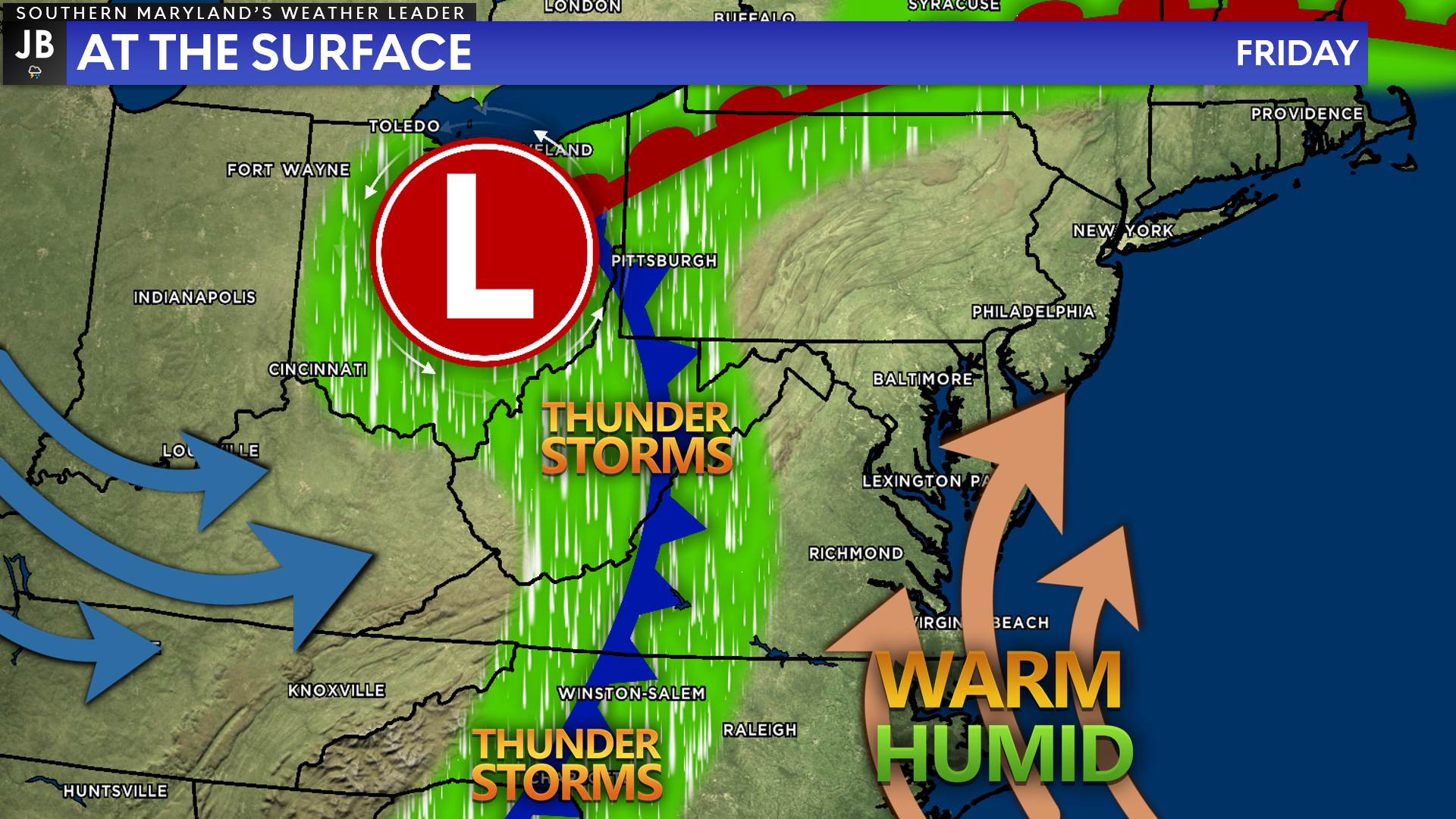
We have been stuck with an onshore, easterly flow leading to our damp and overcast conditions the last few days. Tonight, a warm front will lift northward, allowing for a more southerly component to the wind to develop. This will allow warm and humid air to surge northward ahead of an incoming cold front from the west.
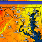
The southerly flow on Friday will allow temperatures to get into the upper 70s and lower 80s, with dewpoints getting into the upper 60s. This combination will make it feel quite warm and humid, and it will lead to the development of storm energy in the atmosphere. The interaction between the warm, humid air and incoming cold front will look to be the spark that could trigger storms Friday afternoon and evening.
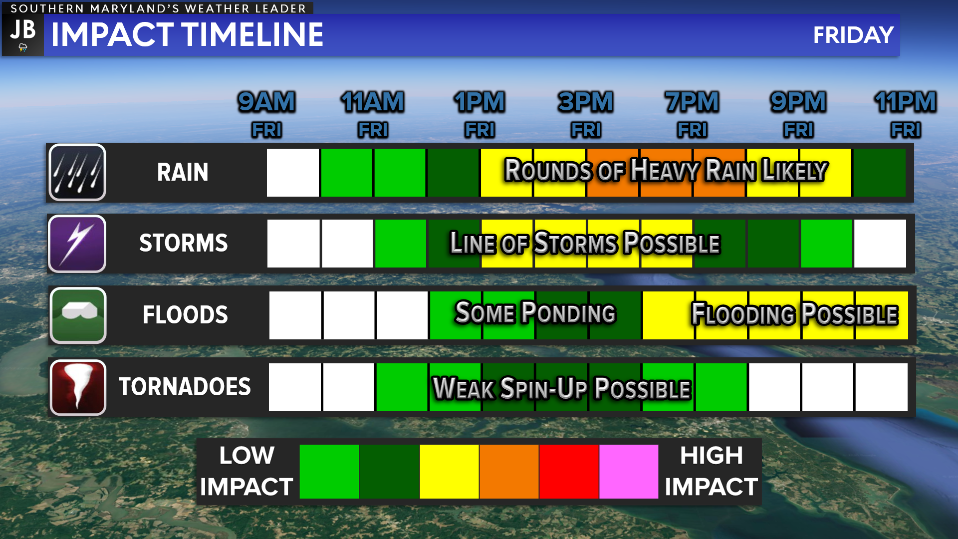
Our Chesapeake’s Bounty Futurecast depicts Friday’s threat quite well. Friday will likely start dry across the region with cloudy skies. There is the potential to see some sunshine early in the morning before the rain moves in. If that happens, we would see even warmer temperatures and increased amounts of storm energy for potential thunderstorms to tap into.
The cold front will look to make its way eastward, across the mountains, throughout the day. As this happens, we will likely see a couple of lines of storms develop. The first line will look to move through during the midday and afternoon hours, likely between 12-6pm. This line will look to produce locally heavy rain, small hail, and damaging winds.
If we see enough sunshine before this initial line moves through, we could see individual storms develop just out ahead of it, posing a risk for a brief tornado.
We may see a brief break in the activity after the first line of storms before another round of rain and storms moves through later in the evening. The second round, which is likely to move through after 8pm, is not likely to be as severe as the first. With that said, the additional rainfall could lead to flooding concerns.
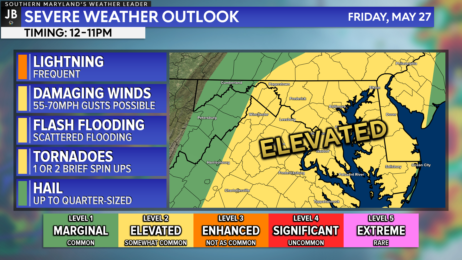
This threat has prompted the Storm Prediction Center to issue a Level 2 “Elevated Risk” of severe weather for our region for Friday. The greatest severe threat will be with the initial line of storms, between 12-6pm. However, the severe weather threat may linger into the night as additional rounds of rain move through.
The primary risk with any storms tomorrow would be the threat of damaging wind gusts up to 70mph. Additionally, there will also be the threat of seeing 1 or 2 brief spin-ups tomorrow afternoon, especially if individual storms can develop before the initial line of storms moves through. We could see hail up to quarter-sized tomorrow afternoon, and flooding remains a risk throughout the day.
This severe weather threat would be substantially higher if we were in the middle of July and temperatures tomorrow were in the 90s with sunshine. That combination would set the table with ample amounts of storm energy and potential. Thankfully, that will not be the case tomorrow. With that said, any additional sunshine and/or warmer temps will lead to a higher severe weather threat. This will be something to monitor throughout the day tomorrow.
Keep in mind that severe weather forecasting is far from a guarantee of anything. The goal of these forecasts is to alert you to the potential of storms, not a promise of storms.
Friday poses a greater than normal severe weather risk, so we must take the threat seriously. If you are looking to travel tomorrow, I would do so either early in the morning, before 8/9am, or late in the evening, after 10/11pm.
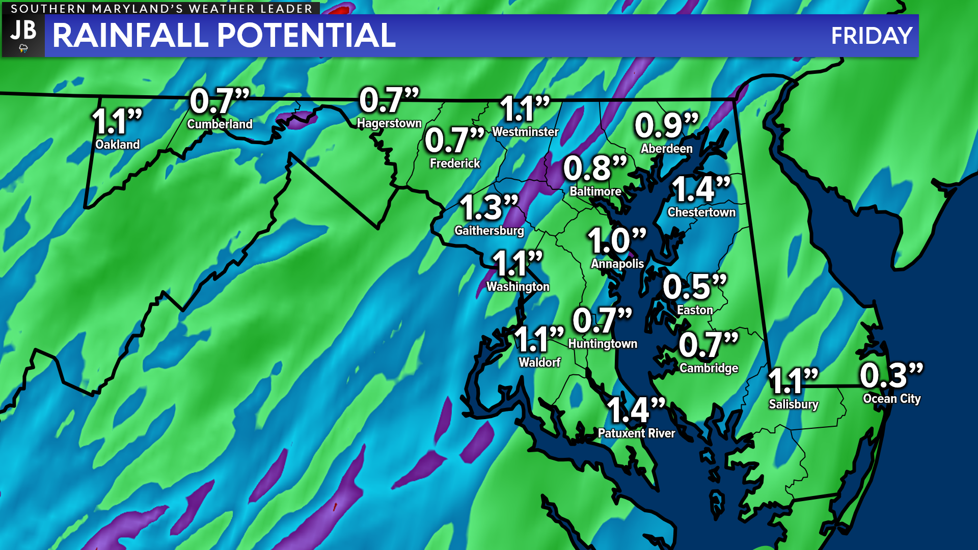
As mentioned above, tomorrow will also present a flooding risk. This is thanks to the multiple rounds of rain that appear likely and the recent stretch of wet weather we have seen. Futurecast shows that up to an inch or two of rain could be possible across the region tomorrow. I would take these exact numbers with a grain of salt, though. This time of year, rainfall can vary a lot by location, thanks to the spotty nature of late Spring rains.
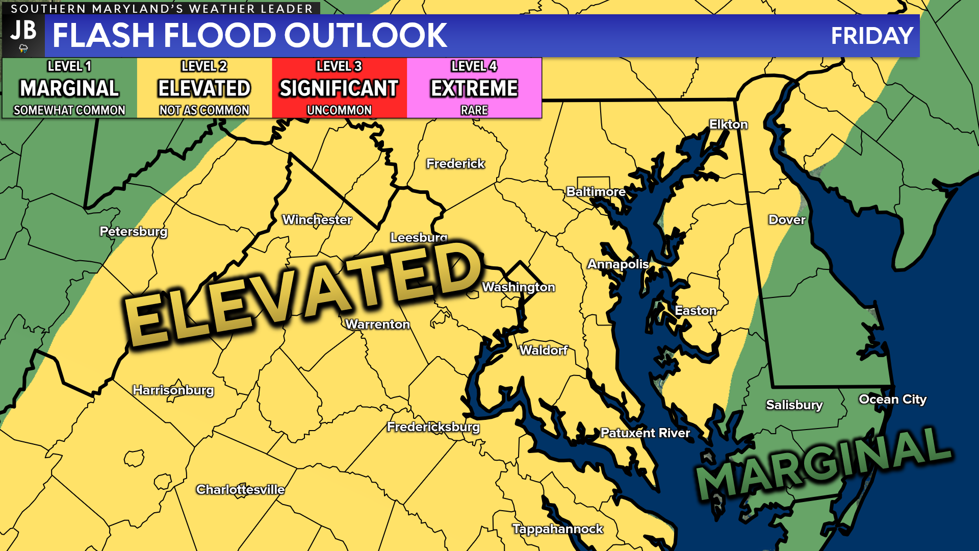
With this flooding risk in mind, the National Weather Service has already highlighted our region as being under a Level 2 “Elevated Risk” of flash flooding for Friday. This scale is a bit different than the severe risk scale. We only use 4 risk categories with flooding, whereas 5 categories are used to assess severe weather risks. This means that a Level 2 risk is much more substantial and worrisome than you may assume.
The atmosphere will possess a high content of water in it tomorrow. This could allow for any storms to put down a lot of rain in a short amount of time. This could lead to several instances of flash flooding across the region! This is the most likely to become an issue the further into the evening we head. Therefore, it will be important to stay aware if you are traveling tomorrow evening.
Stay with JB Weather for the latest information on impacts here in Southern Maryland. You can always access my forecasts and updates here on the website, on Facebook, on Twitter, on Instagram, and on YouTube. JB Weather is Southern Maryland’s Weather Leader, and I am working around the clock to keep you ahead of the storm!
-JB

At All In One Tag & Title, we make quick work of MVA Tag & Title Services! We are located in Owings, MD on the corner of Chaneyville Rd. Give us a call at 301-327-5081 or stop by, no appointment needed! Mention you saw us on JB Weather and get $5.00 off tag & title services. Check out www.allinonellc.net today!
John Bordash
View More PostsJB Weather forecaster John Bordash is working around the clock to provide Southern Maryland, and neighboring communities, with accurate and reliable weather information.